Stormwater Mapping Collaborative for Buzzards Bay
2016 Update
This page describes the BBAC’s first inter-municipal effort to map stormwater discharges in Buzzards Bay. The project, funded by a CZM Coastal Pollution Remediation grant was a success, and the information from the field surveys were added to the Buzzards Bay NEP’s Stormwater Atlas database. In 2015, because of the success of this early effort, and because of needs to meet expected new U.S. EPA stormwater MS4 permit requirements, the BBAC created a new and expanded Stormwater Collaborative, as described on the BBAC website and new Stormwater Collaborative website.
Final Status of the original 2006 Stormwater Collaborative
This initiative was completed in 2006, and culminated in the release of new GIS stormwater maps by the Buzzards Bay NEP visible on our 2007 Stormwater Atlas Update page. A second important outcome of this effort was that the BBAC paid for GIS site licenses for the Greater New Bedford Voc-Tech high school, and teachers and students involved with the program helped create a new Environmental Science and Technology Program at GNB Voc-Tech in 2008.
April 1, 2005 Award Ceremony
The Buzzards Bay Action Committee received a Coastal Zone Management Non-Point Source Pollution Grant in the amount of $18,951 for its application titled Stormwater Mapping Co-operative Program with Buzzards Bay Municipalities. The Buzzards Bay NEP is a partner on this grant. The grant summary is as follows:
The Buzzards Bay Action Committee, in partnership with the Greater New Bedford Regional Vocational Technical High School, will develop detailed stormwater drainage network maps and GIS data sets for several areas in the Buzzards Bay watershed. Through this effort, BBAC will complete the effort begun by the Buzzards Bay NEP (BBP), to map known stormwater discharges and catch basins throughout 7 Buzzards Bay communities, including previously unmapped areas of Bourne, Wareham, and Marion. This effort will also result in the mapping and documentation of the underground drainage pipe system in several areas where these systems were not documented, including Dartmouth, Westport, Acushnet, and Rochester. This new data will be evaluated to establish preliminary priorities for remediation using the methodologies described in the BBP 2003 Atlas of Stormwater Discharges in the Buzzards Bay Watershed. This information will be provided to Buzzards Bay municipalities through BBAC workshops and training.
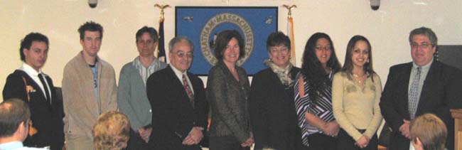
Secretary of Environmental Affairs, Ellen Roy Herzfelder (center), CZM Director, Susan Snow-Cotter (left), and State Representative Shirley Gomes (right center) award a grant certificate award to Leonard Gonsalves (left center) of the Buzzards Bay Action Committee, who will be working with Greater New Bedford Voc Tech High School Students, and their instructor Chris Pires (far right), to implement the grant.
The Stormwater Mapping Collaborative for Buzzards Bay is a public-private partnership to map all storm water drainage systems and discharges in the Buzzards Bay watershed. The initiative will help towns better maintain their drainage systems, identify discharges causing water quality degradation, identify discharge points of road spills, and help towns comply with state and federal requirements to better manage stormwater discharges.
First Effort: Buzzards Bay Stormwater Atlas
For several years, the Buzzards Bay NEP worked to develop the Atlas of Stormwater Discharges in the Buzzards Bay Watershed. In 2003 we completed and distributed hard copies of the Atlas, and CD versions to town boards and libraries in the Buzzards Bay watershed. We also posted the information on our website. The 100+ page report includes maps of more than 2,600 stormwater discharges and more than 12,000 catch basins along the shores of nearly all of Buzzards Bay. (The City of New Bedford and the Elizabeth Island chain of Gosnold were not included in the study.)
As valuable as that effort was, we knew more information was needed. While the Buzzards Bay NEP focused on discharges and drainage networks near to shore, Buzzards Bay municipalities wanted a similar mapping effort for their entire community. They needed this information for their Phase II permits, and to implement town-wide strategies to manage and maintain their stormwater infrastructure. However, the Buzzards Bay NEP did not have the personnel or resources to undertake the mapping of the entire watershed.
The municipal official organization, Buzzards Bay Action Committee, suggested a solution. Recognizing that the Buzzards Bay NEP had in the past used student interns to do routine mapping of stormwater drainage network features in the field, and through their Executive Director’s ties with a regional vocational school, the BBAC proposed to fund students, through a vocational work-study program and summer internships, to map municipal infrastructures to meet the needs of the communities.
Expansion of Effort: Partnership with the BBAC and Voc Tech
In 2003, the Buzzards Bay NEP began a partnership with the Greater New Bedford Regional Vocational Technical High School (Voc Tech), the Buzzards Bay Action Committee (BBAC), and the Town of Dartmouth to establish a stormwater mapping collaborative partnership program to assist Buzzards Bay municipalities. As part of the pilot effort, the BBAC provided more than $10,000 to pay for students, and buy equipment and software to get the program off the ground. The Buzzards Bay NEP provided technical support to guide the effort.
When the Buzzards Bay NEP completed the Atlas of Stormwater Discharges in the Buzzards Bay Watershed in August 2003 (which included some of the Voc Tech students pilot work in the Town of Fairhaven), we recognized the report would be a milestone in the characterization of stormwater degradation of Buzzards Bay. We also recognized that a well-managed student intern program could complete much of the time consuming collection of coordinates and positions of drainage features along roadways.
Because of the success of the pilot effort, the BBAC is seeking to expand and continue the program with support from the Buzzards Bay NEP and Voc Tech. They have also applied for a state Non-Point Source Pollution grant to continue to fund students to map storm drains and catch basin collection systems throughout the watershed.
By the end of the summer of 2004, most of the catch basins in some communities have been mapped, but subsurface drainage networks, and hard to find discharges remain to be documented in large portions of the watershed.
If the BBAC proposal is funded, it is expected that the students and Project will map nearly all known stormwater discharges and catch basins throughout in seven Buzzards Bay, including previously unmapped areas of Bourne, Wareham, and Marion. This effort will also result in the documentation of the underground drainage pipe system in several areas where these systems were not documented in earlier efforts, including Dartmouth, Westport, Acushnet, and Rochester. The map below shows the original catch basins and discharged mapped by the Buzzards Bay NEP (magenta dots), the new areas by the BBAC-Voc Tech effort (green dots), and proposed new areas of focus (brown circles and cross hatched areas).
The Buzzards Bay NEP will evaluate this new data to establish preliminary priorities for remediation using the methodologies described in the 2003 Atlas of Stormwater Discharges in the Buzzards Bay Watershed. This information will be provided to Buzzards Bay municipalities through BBAC workshops, training, and the BBP website. Ultimately, this information will be used by towns, state and federal grant programs to target restoration efforts that are scientifically sound and will most likely achieve improvements in water quality in Buzzards Bay.

Key. Magenta Dots: Catch basins and discharged mapped by the Buzzards Bay NEP (magenta dots) for the 2003 stormwater atlas. Green Dots: Catch basins (principally) mapped by the BBAC-Voc Tech pilot effort in 2003 and 2004, red circles and crosshatch: Areas to be mapped with pending new funding (brown circles and cross hatched areas).