Stormwater Pollution in Buzzards Bay
Related Pages: Stormwater Engineering Procurements | Low Impact Development
This page contains links and information highlighting stormwater management issues for the Buzzards Bay watershed.
New draft municipal MS4 (stormwater) permit
In 2016, the US EPA published in the Federal Register, a new draft small Municipal Separate Storm Sewer System (MS4) general permit for public comment. The permit was approved and takes effect in July 2017. The new permit covers stormwater discharges from urbanized areas of all Buzzards Bay communities. The new permit, which replaces the first permit issued in 2003, is described at this EPA MS4 permit website.
Municipalities may find some of the new requirements challenging to implement, especially with tight fiscal budgets, so priorities will need to be set. Among the challenges to be met in the new municipal permits is that as part of the municipal Stormwater Management Programs (SWMP), municipalities must implement stormwater outfall monitoring programs, and develop strategies to meet bacteria and nitrogen Total Maximum Daily Loads (TMDLs).
As with the last permit, the Buzzards Bay NEP will provide your technical assistance ito Buzzards Bay municipalities implement their Stormwater Management Program. Go to our Municipal MS4 Stormwater Permit page for more background information on the program.
Buzzards Bay NEP’s Stormwater Atlas Project
Since the early 2000s, the Buzzards Bay NEP has been working with municipalities to map stormwater discharges to Buzzards Bay and along streams near the coast. As a result of this project, more than 2500 discharge pipes and road cuts, together with nearly 12,000 contributing catch basins have been inventoried and translated into a geographic information system. This information was first released in a 2003 atlas of stormwater discharges in the Buzzards bay watershed, but work continues to update the stormwater atlas database. For more information on that effort, go to our webpage Atlas of Stormwater Discharges to Buzzards Bay.
Low Impact Development (LID) Stormwater Management Practices
Forty foot wide road layouts in one to three acre subdivisions, coupled with piped stormwater treatment practices adopted in the 1980s and 1990s are causing more loss of habitat, water quality problems, and infra structure maintenance issues than anyone anticipated. Is there a better way?
Yes. It is called “Low Impact Development” (LID), and the new philosophy is causing Buzzards Bay watershed environmental managers and municipal Planning Boards to rethink their local subdivision regulations and environmental bylaws.
Visit the BBNEP’s Low Impact Development page.
9/30/02 Slide Show Presentation to Wareham Planning Board on Low Impact Development (LID)
This is a thumbnail version of the slides in a pdf file. It is 768 kb. We are working on a smaller web page summary. Stay tuned. This slide show was based on a PowerPoint presentation developed by the Puget Sound Water Quality Action Team.
Puget Sound Water Quality Action Team LID Manual
Other Stormwater Topics
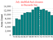 Shellfish bed closures continue decline.
The hard work of Buzzards Bay municipalities and the Massachusetts Division of Marine Fisheries to address stormwater and other pollution problems continues to contribute to declines in shellfish bed closures in Buzzards Bay. The Project has been pleased to contribute to this effort through our grant and technical assistance programs.
See also our BBNEP’s 2006 model Stormwater Bylaws.
TR55 and the Cornell Rainfall Precipitation Atlas Maps
Technical Release 55 Urban Hydrology for Small Watersheds, or “TR-55” for short, was a document developed by the USDA Soil Conservation Service (SCS, now called the Natural Resources Conservation Service or NRCS), to present simplified procedures to calculate storm runoff volume, peak rate of discharge, hydrographs, and storage volumes required for floodwater reservoirs in small watersheds in the United States. The document existed as a form of worksheets, but later converted to a computer program. Subsequently more sophisticated commercial hydrology packages became available, but the foundation of many of these packages are the SCS runoff equations, curve number tables, and rainfall maps in TR-55 to predict the peak rate and total volume of runoff. Many government regulations specify the use of curve number tables and rainfall maps in the original TR55 document. The current Windows version of TR-55 software is at this link: USDA WinTR-55 software website.
The TR55 rainfall maps are based on those contained in the technical publication TP20, which was based on an analysis of rainfall data prior to 1961. In 1993, Wilks and Cember published a new analysis of rainfall patterns based on data to the 1990s in the publication below. This publication is sometimes referred to as the “Cornell Rainfall Atlas.”

Cornell University’s Atlas of Precipitation Extremes for the Northeastern United States and Southeastern Canada, NRCC Research Publication RR 93-5. (10 MB pdf file).
An important finding of their analysis was that 24 hr rainfall amounts were much higher for the rarer storms, particularly the 100-year, or 1 percent storm. This finding and other differences for lesser storms is further explored for Massachusetts conditions by Patrick Garner at this link: www.patrickgarner.com/rainfall.html
Because this Cornell Rainfall Atlas data is more up to date, and because extreme precipitation events are expected to be more extreme with climate change, the Buzzards Bay NEP is encouraging area municipalities to adopt the Cornell Atlas data in their regulations. To facilitate the use of the atlas data Cornell University has developed an Extreme Precipitation Online Tool for NY and New England where you can enter an address, and determine amounts for the 1 to 500 year probability storms rainfall amounts for different periods.
LINKS TO RELATED SITES
MA DEP stormwater information.
National BMP Case Study Database
Metropolitan Council Urban Small Sites Best Management Practice Manual
NC State University Stormwater Group Publications
US EPA’s Stormwater Calculator
UNH Stormwater Center
CICEET has a launched the Center for Stormwater Technology Evaluation and Verification, located at the University of New Hampshire. The center conducts field testing of stormwater treatment technologies and offers workshops for those developing and implementing stormwater management plans. For more information, and a schedule of workshops, visit their site.
Other Documents and Data
The Coalition’s ‘Head of the Bay’ Stormwater Monitoring Project
A July 2007 report Identifying stormwater discharges with elevated levels of bacteria in the towns of Bourne, Wareham, and Marion.
Daily Rainfall Data from the UMass Cranberry Experiment Station, 1988-1998 (Excel file). Prepared by the Buzzards Bay NEP.