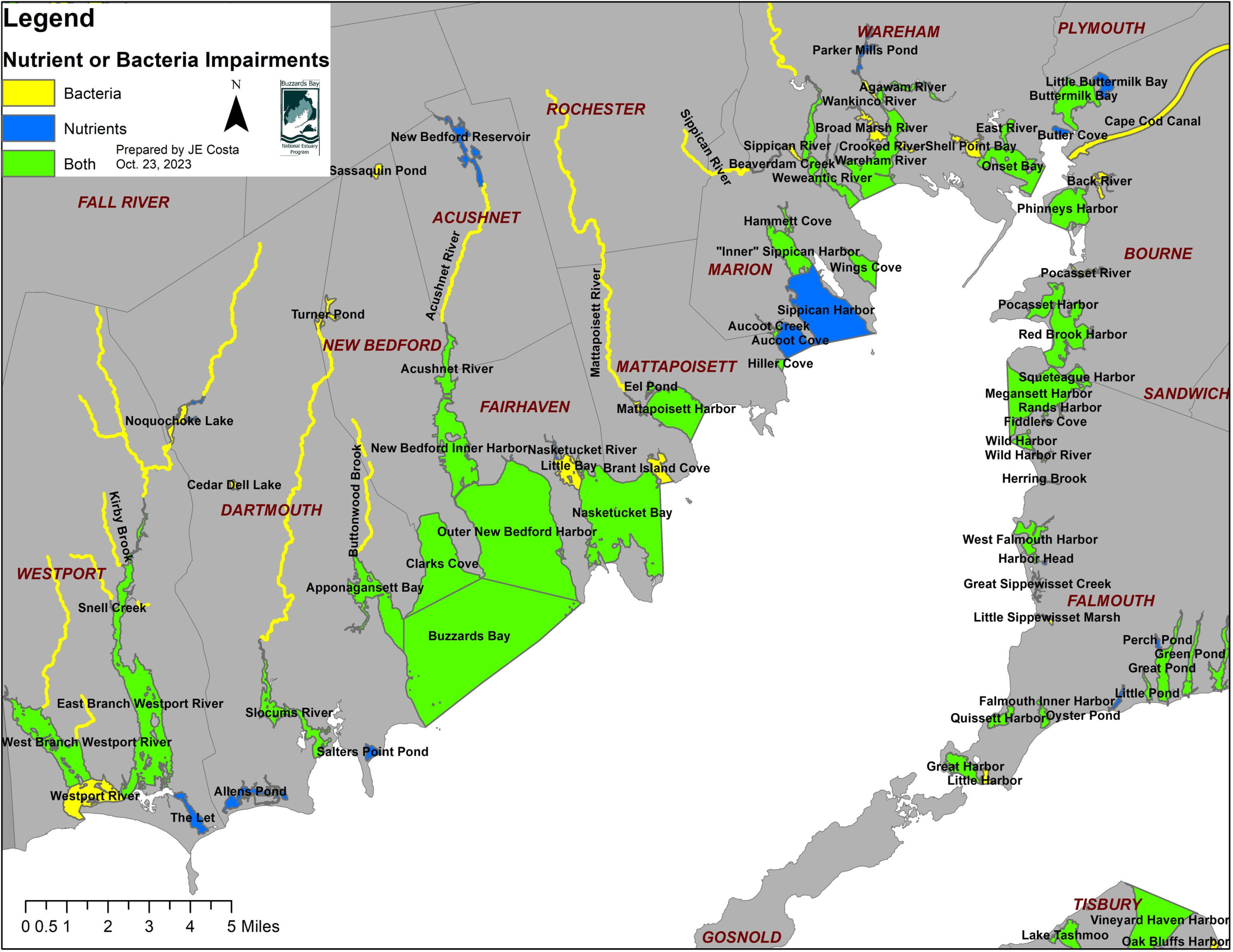
The Buzzards Bay NEP supports actions to reduce nutrient and bacteria pollution to receiving fresh and salt waters. The interactive map below shows waters impaired by either nutrients or pathogens (indicated by bacteria indicator species). The map displayed below is a simplification of Massachusetts DEP’s 2022 Integrated List of Impaired waters (“303(d) list”), and only shows waters impaired by nutrient pollution (red), bacteria pollution (yellow), or both (orange) for Buzzards Bay and nearby surrounding areas. For freshwater systems, the nutrient contaminant of concern is phosphorus. For marine waters, the nutrient contaminant of concern is nitrogen.
More information about the Massachusetts 2022 Integrated list is found at: https://www.mass.gov/lists/integrated-lists-of-waters-related-reports#final-2022-integrated-list-of-waters-
DEP’s: interactive map of impaired waters, including historical changes of classification can be found at: https://arcgisserver.digital.mass.gov/MassDEPWaterQuality/Home/Index
MassGIS data for the 303(d) integrated list is available at:
https://www.mass.gov/info-details/massgis-data-massdep-2022-integrated-list-of-waters-305b303d
The DEP GIS Integrated List database consists of 21,423 impairment records defined by 93 impairment categories assigned to 2,785 water features (pond or bay polygons or river segments). To prepare the map shown here, the impairment causes for each unique feature were combined, and features with impairments caused by either nutrient and bacteria pollution were extracted and presented here. River segments were made into 100 ft wide polygons and added to the coverage. Click on any feature for more information about a water body. In some cases, the combined causes of impairments exceed the 254-character limit of the software, so the cause of the impairment in the pop-up window may be incomplete.
If you would like to download this coverage of nutrient and bacteria impaired waters for all of Massachusetts, download this Google Earth file: IL2022_NB_IMPAIRED_WATERS_MA.kmz, or if you use GIS software, download this shapefile: IL_2022_POLY_NB_IMPAIRED_MA.zip.
Report errors to joe.costa@mass.gov .