2005 Marion Watersheet Zoning Model Dock and Pier Bylaw
Note: The Marion Planning Board did not hold hearing on this proposed bylaw for either the Fall 2004 or Spring 2005 Town Meeting The Marion Marine Resources Commission developed a model watersheet-zoning bylaw with the assistance of the Buzzards Bay NEP. The bylaw was anticipated to come to fall 2004 town meeting for approval after review by the Planning Board, however, the Planning Board was unable to hold the hearing on the language of the zoning change as required to bring the bylaw to town meeting. They again failed to hold a hearing for the Spring town meeting, and the proposed zoning strategy appears to be tabled.
The issues that prompted the development of this bylaw remain unaddressed. Despite the lack of a vote on the issue in Marion, several other towns are studying the approach laid out here to determine its applicability in their community.
Background
Eight years ago, the Town of Marion adopted a land-zoning bylaw that limited the construction of docks on non-conforming lots. The zoning law allowed docks to be built only if: “4. the zoning map does not designate the area as a no pier construction zone. [no designations were made by the town] and 5. The lot for which the permit is sought fully conforms with the current area and frontage requirements for the district in which it is located.” (Section 7.4.5 Accessory Piers, Marion Zoning Bylaws).
This dock exclusion bylaw essentially disallowed the construction of docks from very small lots, because they were “non-conforming” to the zoning for lot size. The town felt the bylaw was working well until four years ago, when the Town of Marion “down zoned” most of the town, creating many existing non-conforming lots along the waterfront. This change in zoning effectively prohibited new dock construction over large areas as shown by the map below (red parcels became dock exclusion zones).
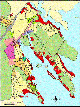
This change in zoning resulted in a current dock prohibition (based on lot size and road frontage) of over 55% of the Marion waterfront. Town officials view this situation as unacceptable. Consequently the Marine Resource Commission (MRC) wanted to develop a rational on dock exclusion based on protection of natural resources, and they asked the Buzzards Bay NEP for help in developing those criteria.
Resources evaluated for criteria ranking for dock exclusion zones in Marion included habitat for eelgrass, quahogs, soft shell clams, razor clams, diamond-backed Terrapin (nesting), oysters, bay scallops, and swimming beaches using the point system below.
| Resource | Points |
| DEP eelgrass (Zostera marina) | 4.0 points |
| MSD bay scallop (Argopecten irradians) & eelgrass habitat | 3.7 points |
| MSD soft shell clam (Mya arenaria) (poor fair good excellent) | 0.9 – 3.6 points |
| MSD quahog (Mercenaria merceneria) (poor fair good excellent) | 0.9 – 3.5 points |
| MSD oyster (Crassostrea virginica) (poor fair good excellent) | 0.8 – 3.2 points |
| DMF bay scallop (Argopecten irradians) | 3.1 points |
| DMF razor clam (Ensis directus) | 2.7 points |
| NHESP diamond-back terrapin (Malaclemys terrapin terrapin) | 1.6 points |
Scoring strategy based on Athey 1982 book, Systematic Systems Approach (corporate decision making).
This scoring was superimposed as GIS data layers on the Marion coastline by Buzzards Bay NEP staff to create the cumulative ranking map shown below.
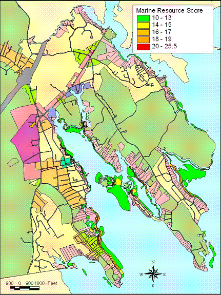
These results were not to define the decision-making, but to aid the MRC in making their final recommendation for dock exclusion zones in Marion. The Marion MRC’s final recommendations were based on policy decisions and other factors besides this map, including the location of existing beaches and docks, and included setbacks from other docks, and a minimum frontage requirement.
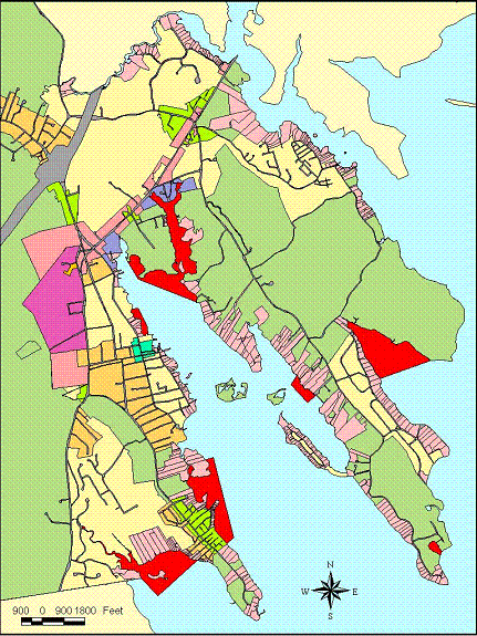
In the end, the MRC proposed the dock exclusion zone and proposed zoning regulations below, that will be voted upon at town meeting.
Read the March 2004: Docks and Piers model watersheet zoning bylaw (29 kb pdf).
Finally, it is important to recognize that the legislation creates dock exclusion zones. Any dock proposed for other areas in town still need to get approval through the permitting process, which includes a state wetlands permit from the Conservation Commission, a state Chapter 91 waterways license, and a federal Army Corps wetlands filling and rivers and harbors permit.
Buzzards Bay watershed towns should contact the Buzzards Bay NEP if they need technical support on water sheet zoning bylaw development.