Buzzards Bay Beaches & Contamination Info
Related Pages: Shellfish Bed closures | Seafood
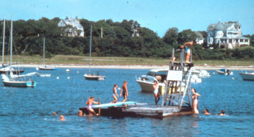
There are 310 miles of beautiful scenic coastline along Buzzards Bay (see Note 1). But where do people go swimming? Well on any hot summer day, you will find many beach front property owners on their private beaches, but more likely residents will be swimming at one of the public beaches or resident association beaches in the map shown below. Some of these beaches are larger or more popular than others. Without question, the most popular and well populated beach in the Buzzards Bay watershed is the Horseneck Beach State Reservation in Westport. With its fine sands and heavy surf, on a hot summer day, 25,000 people or more can be found on the beaches surrounding Buzzards Bay. On the Cape Cod side of Buzzards Bay, Old Silver Beach in North Falmouth is perhaps the most popular.

Click on a dot for more information about that beach.
Beach Ownership, Public and Private Beaches
There are 13.4 miles of public beaches (municipal and state owned) in Buzzards Bay, with an additional 31.9 miles of “semi-public” beaches (see Note 2). Semi-public beaches include some large tracts of state, municipal, and private conservation coastal lands where the public may have some right to use, beach association and community beaches, private pay-to use beaches, club and resort beaches, and other stretches of coastline where more than a single owner is allowed use. Many of the semi-public areas are not open to the general public. The rest of coastline is privately owned, generally to the low tide mark.
Massachusetts is one of five states (see note 3) with property ownership to the low tide mark. More information on the origins of this, and public rights in the intertidal zone in Massachusetts can be found on our Public Access to the Coast page, and Massachusetts Coastal zone Management’s Public Rights Along the Shoreline page. Please see the additional references and cases described at this website: Massachusetts Law about Beach Rights.
Beach Access and Fees
Beaches owned by cities, towns, and the state are open to any member of the public (see our Public Access Page for more information). However, to park at a municipal beach parking lot, you may need a beach-parking sticker. Only two towns, Wareham and Falmouth, have daily fee beach parking lots. These are parking lots, with an attendant that allows anyone, including non-residents, to park at a beach parking lot for a fee. For example, at Old Silver Beach in Falmouth, anyone can park all day at the beach lot without a beach sticker for $20. The table below shows the fees in 2004 for Buzzards Bay towns. Call your town or city hall for the latest information.
Municipal Beach Parking Sticker Costs
| Town | Resident/ Taxpayer | Non-Resident | Senior | Town Fee parking |
| Falmouth | $20 | $125 (season) | not offered | 3 beaches, $10-$20 |
| Bourne | $10 | $30 | not offered | none |
| Wareham | $20 | $40 | $5 at 65 | $5 |
| Mattapoisett | $5 | not offered | free at 65 | none |
| Marion | free | not offered | free | none |
| Fairhaven* | $25 | not offered | free at 60 | $5* |
| New Bedford | free | free | free | none |
| Dartmouth | $25 | $25 | $15 at 65 | none** |
| Westport | $20 | not offered | $10 at 60 | none*** |
| * Fairhaven is the only town with a fee ($2) for bicyclists and pedestrians. They also have a $5 auto daily parking fee for residents only. **There is $7 parking fee at the state operated Demarest Lloyd State Park. ***There is $7 parking fee at the state operated Horseneck Beach State Reservation . | ||||
Looking for information on the annual Buzzards Bay Swim? Then visit the Buzzards Bay Coalition web page.
Contamination and Testing Information
We often receive inquiries about pollution at public beaches, and public health safety issues. Most beaches in Buzzards Bay have very clean waters and are safe to swim in. However, there are a few beaches that typically have high fecal coliforms after a heavy rain (generally an inch or more). These beaches with elevated coliforms tend to be near rivers, salt marsh channels, or stormwater pipes. Typically these areas have notably more turbid waters after a rain. At these beaches you can minimize your exposure to pathogens by not swimming during a heavy rain or for a day or two afterward. For example, at the Mattapoisett Town Beach, we have documented (and notified the town) about elevated coliforms discharging from a pipe at the town beach after heavy rains. Private and semi public beaches in the east branch of the Westport Rivers also heavy very high bacteria levels after heavy rains. Beaches within upper portions of harbors also have elevated bacteria levels after heavy rains.
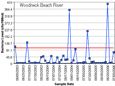
Woodneck Beach River in Falmouth, MA drains a salt marsh and typically has elevated bacteria levels after heavy rains. The low levels in the graph represent dry days. The elevated levels are generally on rain dates or within a few days of a very heavy rain.
Municipalities are supposed to implement automatic rainfall beach closures at these types of sites, but to our knowledge, no municipality has implemented such a program. Municipalities are also supposed to monitor water quality during adverse conditions (like during rains) for sites with histories of violations, but most monitor the beach on the same day every week, rain or shine, and have made little effort to document these rain related problems.
Click on the link below to see how often your beach fails.
Current water quality beach data for most Massachusetts Towns from MA BEHA
Click on map -graphical interface. This is the best site because it shows you the actual bacterial levels measured.
Current Barnstable County Beach Results Postings (Cape Cod towns only)
Unfortunately, this site only shows if a beach was a “pass” or “fail”, and gives no indication about relative water quality among sites.
To check out past performance of beach testing in your town, visit:
Massachusetts Bureau of Environmental Health Assessment past summary reports
Excerpts of testing results for Buzzards Bay communities for 2003 (required reporting, 40 kb pdf).
If your beach is not listed, it may not be tested. Call your board of health to find out if your beach is tested.
Beach Links for Massachusetts and Buzzards Bay
Surfrider.org “State of the Beach” for MA
BEACH MONITORING REQUIREMENTS FOR PUBLIC AND SEMI-PUBLIC BEACHES IN MASSACHUSETTS
PROMULGATED APRIL 2001
Prior to 2001, in Massachusetts, under Chapter 111 of the Massachusetts General Laws, the Massachusetts Department of Public Health regulations (105 CMR Section 445) required that bathing beach samples be taken at least twice monthly during the bathing season. These regulations had also failed to spell out any objective standard requiring beach closure, and instead state “A [total] coliform count of 1000 per 100 ml shall be considered a guide requiring additional investigation, survey or special analyses as may be necessary.”
All this changed in 2001 when new regulations were issued requiring weekly testing, and a new bacterial standard for public and semi-public beaches. Semi-public beaches are those operated by trailer parks, campgrounds, motels, condominiums, clubs, and similar entities. Some Highlights of these regulations:
445.031: Indicator Organisms
(A) For marine water, the indicator organism shall be Enterococci.
(1) No single Enterococci sample shall exceed 104 colonies per 100 ml. and the geometric mean of the most recent five (5) Enterococci levels within the same bathing season shall not exceed 35 colonies per 100 ml.
(B) For fresh water, the indicator organisms shall be E. coli or Enterococci.
(1) No single E. coli sample shall exceed 235 colonies per 100 ml. and the geometric mean of the most recent five E. coli samples within the same bathing season shall not exceed 126 colonies per 100 ml; or
(2) No single Enterococci sample shall exceed 61 colonies per 100 ml. and the geometric mean of the most recent five (5) Enterococci samples within the same bathing season shall not exceed 33 colonies per 100 ml.
(C) Frequency.
(1) The Board of Health, its agent, or any other authorized person shall collect the bacteriologic samples:
(a) Within five days of the opening of the bathing season; and
(b) At least weekly during the bathing season at a time and day approved by the Board of Health or the Department; and
(c) Prior to reopening a beach after closing for any reason.
(2) Testing for oil, hazardous materials, or heavy metals shall only be required if the operator, the Board of Health, or the Department has information indicating possible contamination of the bathing beach or bathing waters from oil, hazardous materials or heavy metals.
445.035: Sampling and Analysis at Semi-Public Beaches
(A) The operators of semi-public bathing beaches shall pay for the costs of testing, monitoring and analysis of bathing waters adjacent to such semi-public bathing beaches.
445.040: Posting and Reopening Notifications
(A) Posting. Whenever the bathing water quality does not meet the requirements of 105 CMR 445.030 or after any significant rainstorm at a bathing beach where there has been a history of violations of the water quality requirements contained in 105 CMR 445.030, the Board of Health, its agent, or any other authorized person shall immediately, and in no event later than 24 hours, notify the Department, and post or cause to be posted, a sign, or signs, at the entrance to each parking lot and each entrance to the beach stating:
WARNING! NO SWIMMING
SWIMMING MAY CAUSE ILLNESS
and a graphic depiction of a swimmer in a red circle with a diagonal hatch mark. The sign shall also contain the reason for the warning, the date of the posting and the name and telephone number of the board of health.
The complete DPH regulations (105 CMR 445) Promulgated Spring 2001
2003 DPH letter to Boards of Health on Public Health-Based Beach Evaluation, Classification, and Tiered Monitoring Plan
“This Public Health-Based Beach Evaluation, Classification, and Tiered Monitoring Plan proposed by the Massachusetts Department of Public Health (MDPH) has been developed in order to ultimately direct water quality monitoring resources to the beaches that pose the greatest health concern so as to facilitate the identification and clean up of pollution problems, while those beaches with more pristine records can be monitored less often than the initially required weekly routine monitoring pursuant to both the Massachusetts and federal beach acts.”
Related Information
Annual Massachusetts DPH Beach Testing Reports
OTHER CONTAMINANTS RELATED TO HUMAN HEALTH
Massachusetts DPH Mercury & PCB advisories and DMF shellfish bed closures
Restrictions on pesticides in Zone 2s (public water supply recharge areas)
What is the “Geometric Mean” and how to calculate it (used for swimming beach and shellfish bed closures)
Note on 2003 Bouchard No. 120 oil spill impacts on Buzzards Bay beaches
No Town or State beaches were ever officially closed due to oil pollution because the April 2003 spill occurred well before beaches were opened for the summer. By early July 2003, all public sandy swimming beaches had been cleared of oil. However, the public was discouraged or prevented from going to certain rocky areas on public and private beaches where clean-up crews were actually removing oil, or where oiled beached cobbles were excavated with heavy equipment.
No area Board of Health issued a health advisory against swimming in Buzzards Bay. The primary risk currently associated with the oil spill was contact with tar balls. Most of these tar balls are generally on rocks or other surfaces. Very little oil was either in, or floating on, the water during the 2003 swimming season. By July 2003, most of the remaining oil had lost most of its volatile (and generally more toxic) constituents. Any remaining during the summer of 2003 and after will be tar-like in nature. The residual oil in the summer was difficult to remove from bathing suits, and theoretically could cause a rash in those with allergic reactions petroleum products. It was recommended that oil on skin be removed with baby oil, and during the early summer of 2003, information packets were distributed to residents and beach goers, some of which contained samples of baby oil. In the summer of 2004, a small amount of oil was found related to the Bouchard oil spill, but there were no closures to any swimming beaches.
Note 1: This total of 310 miles of coast is for the mainland portion of Buzzards Bay, including both the Cape Cod side and western or “south coast” side of the bay. This total does not include the 9 miles of coastline of the Cape Cod Canal within the Buzzards Bay watershed, nor does it include an additional 40 miles of coastline on the bay facing side of the Elizabeth Islands. For those interested, the length of coastline from Westport to Wareham (“South Coast”) is 245 miles.
note 1 return to text
Note 2: For those interested, the length of public and semi-public beaches from Westport to Wareham (“South Coast”) is 11.7 and 26.6 miles respectively.
note 2 return to text
Note 3: The other states are Delaware, Maine, Pennsylvania, and Virginia.
return to text