Related Pages: Tidal Datums | Salt Marsh Expansion with SLR | Atlas of Tidally Restricted Salt Marshes | Tidal Datum Viewer | Salt Marsh Lower Boundary Elevation | Interactive map of marsh monitoring sites | Migrating salt marshes | Tidal Elevations and Datums in Buzzards Bay |
Salt marshes are among the most productive ecosystems in the world even exceeding most types of agricultural land. For a long time salt marshes and tidal areas were considered unproductive land to be filled. Today they are among the most highly protected wetland types in Massachusetts and enjoy stringent protections. They are recognized as an important resource that provides wildlife habitat, produces large quantities of plant and animal biomass, exports food to nearby coastal food webs, protects the coastal zone from floods, and absorbs some water-borne contaminants. Salt marshes add greatly to the aesthetic diversity of the coastal landscape, providing a source of recreational enjoyment through fishing, shellfishing, water fowling, and nature appreciation in all seasons.
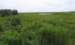
Salt marshes typically are located in intertidal areas behind barrier beaches, bordering quiet water, or along the banks of tidal rivers. Significant salt marsh areas are located in Dartmouth, Wareham, Westport, and Fairhaven.
Salt marshes have been well protected in Massachusetts under state and local laws for decades, and the acre-age of salt marsh in Buzzards Bay has been relatively constant. The MassGIS land use analyses, where the methodology has been relative consistent, show that be-tween 1971 and 2005, there has been negligible change in marsh area (1971: 4,950 acres; 1985: 4,945 acres, 1999: 4,941 acres; 2005: 4,971 acres).
“High marshes” are the areas of salt marshes inundated only during spring tides and characterized by the presence of the grass Spartina patens. “Low marshes” are the areas submerged by tides daily and characterized by the grass Spartina alterniflora. The high marsh is dominated by salt-tolerant plants and terrestrial species of animals. Many shorebirds nest in the high marsh. Estuarine and marine invertebrates and fish are often abundant in low marshes and associated tidal creeks. For a better understanding of how the uper and lower marsh relate to tidal elevations, go to our salt marsh climate study technical page.
Water draining from marshes enters coastal waters via streams or groundwater. Because dense layers of peat under marshes impede groundwater flow, groundwater transported from uplands may break out at the surface in springs or travel under the marsh’s peat. The specific pathway of transport of waterborne contaminants such as coliforms and nitrogen through and around marshes has management implications because of potential human health risks and rates of attenuation differ depending on whether land drainage passes over or under a marsh.
Ditching of salt marshes has been a common practice since the 1930s as a method of mosquito control. The objective of ditching is to drain pools of water (“pans”) in salt marshes as well as to provide fish access to these pools to feed on mosquito larvae. Today, new ditches are not commonly dug but old ditches continue to be maintained. The practice has come under increased scrutiny, and some scientists feel that valuable feeding habitat for shore birds and waterfowl may be lost by ditching efforts. Some open-marsh management programs are developing better ditching patterns to allow enhanced access by fish. The only alternative to ditching for mosquito control is limited pesticide use.