Information on the Buzzards Bay Coalition State of the Bay Report
Related Pages: Eutrophication Index
Coalition State of the Bay and BayWatchers Reports
One of our partners, The Buzzards Bay Coalition, produces State of the Bay Reports. The Buzzards Bay NEP has partnered with the Coalition and analyzed data and produced maps and graphics in support of the Coalition’s work. These State of The Bay reports are also a supporting task in Buzzards Bay NEP Cooperative agreements with EPA. These reports also compliment the status and trends evaluations and CCMP tracking initiatives now undertaken by the Buzzards Bay NEP. Prior to the State of the Bay reports, during the 1990s the Coalition frequently issued “report cards” evaluating the performance of municipalities in protecting the resources of Buzzards Bay and in implementing the Buzzards Bay Comprehensive Conservation and Management Plan (CCMP).
Coalition’s 2022 State of the Bay Report
The Buzzards Bay Coalition’s current and past State of the Buzzards Bay reports are available on their website at this page. The 2022 report found conditions improved in Buzzards Bay somewhat, and these improvements “reflect significant reductions in nitrogen and toxic pollution.” The report also noted the bay faced new challenges because of climate change, which is “moving the goal post and changing the Bay restoration landscape. ” The Coalition further noted that “warmer water in the Bay — up 4 degrees Fahrenheit since the mid 1990s — now allows bacteria to persist longer leading to shellfish bed and beach closures, and extends the season of biological activity in the Bay encouraging algae to bloom on lower levels of nitrogen. In effect, we need to remove more nitrogen in a warmer Bay to see the same water quality improvements.” The report also acknowledged that rising sea levels are eroding and drowning Buzzards Bay saltmarshes.
Earlier Reports and History
The Buzzards Bay Coalition hosted the first State of the Bay in Conference in 2003 (the meeting was actually postponed a month because of the Bouchard No. 120 tank barge oil spill). The Buzzards Bay NEP worked with the Coalition to gather and evaluate data to be presented at the meeting, ranging from shellfish bed closures to open space acres protected, and preparing maps of Buzzards Bay resources. In one presentation, Buzzards Bay NEP Executive Director, Dr. Joe Costa gave a presentation on the historical changes in eelgrass distribution in Buzzards Bay.
On June 15, 2007, The Buzzards Bay Coalition released a new State of the Bay Report, finding that the Bay’s indexes of water quality and living resources have declined since their last report in 2003. The new score for the bay was 45, down from the 2003 score of 48. The Coalition developed the report based on data and information from agencies, scientists, and land use planners. The report uses the best available current and historical information for indicators in three main categories: pollution, watershed health, and living resources. The Buzzards Bay National Estuary Program contributed to the effort by evaluating certain data sets, particularly data on shellfish bed closures, eelgrass cover, and various land use and wetland change calculations.

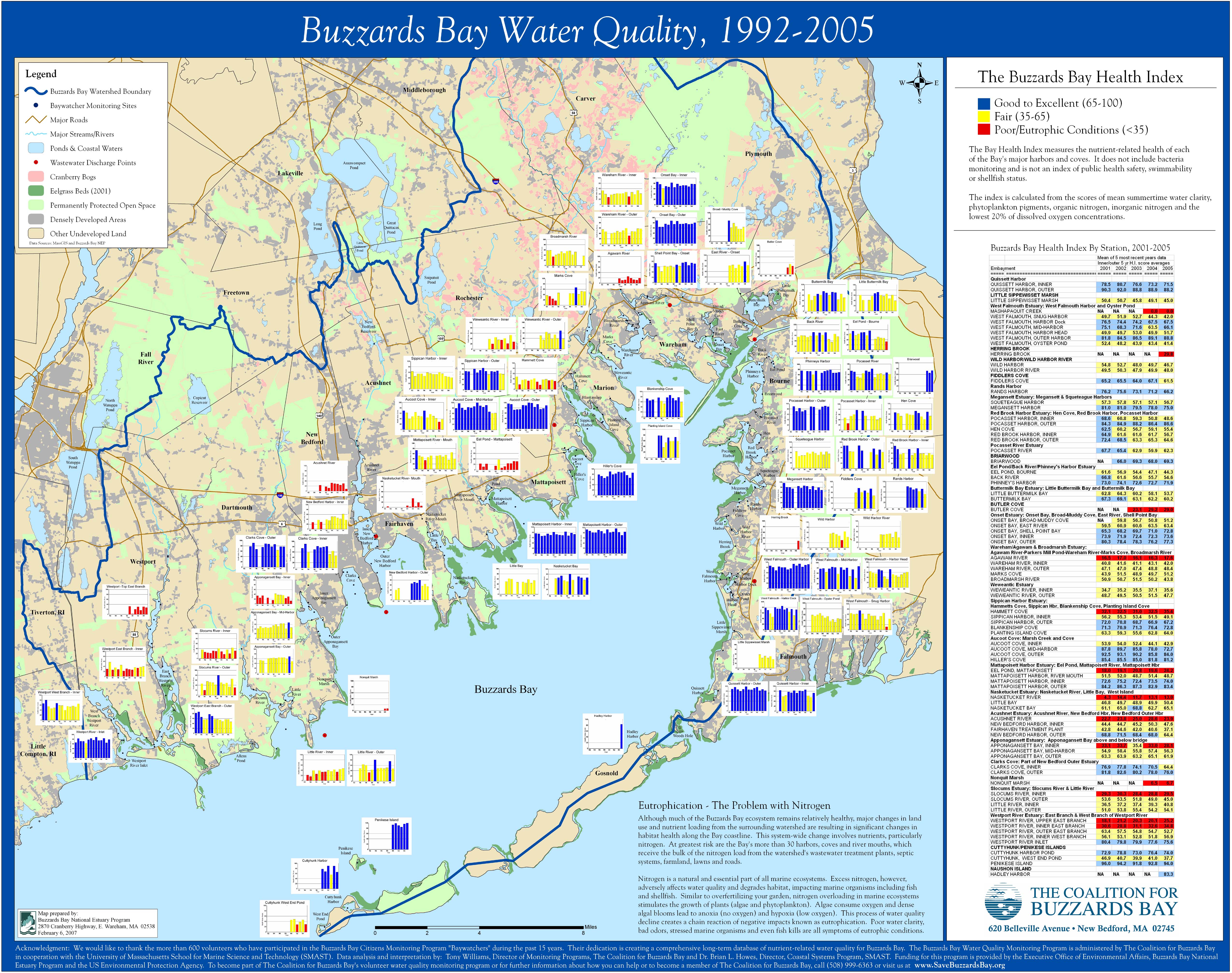
Coalition’s 1992-2005 State of Bay Trends Map
Full Screen Version of Map (294 kb jpg file)
Extra Large Print Quality Version (2.7 MB jpg file)
The Buzzards Bay Coalition’s State of the Bay assessment focuses on water quality and living resources in the nearshore areas. From a local perspective, this makes lots of sense because it is these nearshore areas that are most impacted by human activity, and it is these nearshore areas that are also most utilized and enjoyed by residents, whether they are swimming, fishing, or beach walking. For example, the shellfish index is based upon the portion of Buzzards Bay nearshore areas closed to shellfishing. Certainly shellfish exist in central Buzzards Bay, and some shellfishermen work these deep waters with special equipment, but for the most part, most Buzzards Bay commercial and recreational shellfishermen work in bays and shallow waters nearshore affected by pollution.
From a scientific perspective, these nearshore areas also tend to have some of the most important and diverse habitats that sustain or act as nurseries for numerous species. These coastal areas and the embayments around Buzzards Bay each have a story to tell of impacts to water quality and living resources, affected principally by activities in surrounding watersheds of each embayment. Each of these embayment will need a custom management strategy to solve their problems, and the success or failure of these local efforts will be documented by water quality and living resource monitoring programs like these.
Baywatchers Report
Initially the Buzzards Bay NEP prepared the Baywatchers reports. In December 1992, the Buzzards Bay NEP issued the results of first year of monitoring in the first Baywatchers report. A second Baywatchers Report was issued in the spring of 1994 (read the 1994 Baywatchers Report 1.8 MB pdf file, not all graphics rendered). In the Fall of 1996, the Buzzards Bay NEP National Estuary Program and the Buzzards Bay Coalition jointly issued the third Report of the Buzzards Bay Citizens’ Water Quality Monitoring Program 1992-1995. This report can be viewed on this 1996 water quality report page. Afterwards, The Coalitions for Buzzards bay assumed full management and oversight of reporting the findings. Go to The Buzzards Bay Coalition website to obtain all subsequent reports.
Links
Coalition’s 2003 State of Bay Report (2.1 MB pdf file)