Buzzards Bay Oil Spill Cleanup Status
Status Reports and Activities through January 2011
Most areas contaminated with oil were cleaned up in 2003, and the emergency phase of clean-up activities overseen by the Coast Guard terminated in September 2003. Afterwards, a new contractor, GeoInsight (a Licensed Site Professional), continued cleanup activities under state law, with oversight by Mass DEP. Most of the remaining areas were cleaned up by the end of 2004. However, there were a few areas where oil was buried by shifting sands, where oil accumulated in cracks among boulders, or where oil could not be removed from salt marshes without destroying them. Cleanup of these handful of beaches continued through 2006 and essentially ceased by 2007. The Division of Marine Fisheries also kept closed those shellfish areas that had not yet been certified as clean. Cleanup activities, in a practical sense, ceased in 2007, and nearly all the remaining dozens of acres of shellfish resource areas that were still closed between 2005 and 2007 were opened by then. In 2009, GEOInsight submitted their final report to the state.
In November 2010, the State, Federal Government, and Bouchard Transportation Co Inc. reached a partial settlement on the Natural Resource Damage Assessment for the spill, totaling $6 million. The impacts to certain birds, including endangered roseate terns, has not yet been finalized. Also in November 2010, one of the class action suits for damages claimed by property owners around Buzzards Bay was settled, totaling $11.45 million. In January 2011, a second settlement totaling $12 million, was agreed relating to a separate class action lawsuit with Mattapoisett residents. Information about these settlements pare included on our oil spill costs page and, in the websites below, which have more information for property owners about the settlements, including court documents about the spill impacts.
Reports and Data
We periodically receive reports and files prepared by GEOInsight Inc., the licensed site professional who oversaw the final phases of the cleanup after the Incident Command Center was closed in September 2003. These reports are posted below. The last documents received from Geo Insight were the May 2009 documents described below.
In May 2009, we received from GEOInsight Inc. the Phase IV Final Inspection Report, Phase IV Completion Statement, and the Partial Class A-2 Response Action Outcome statement dated April 27, 2009. This report is likely the final reporting on cleanup activities. Right click this link for the Geo Insight April 2009 report to view the combined report (a 19.5 MB pdf file; if you attempt to open it in your web browser by left clicking, you may receive a timeout error).
In the October 2008 we received a report prepared by GEOInsight Inc. titled “PHASE IV COMPLETION REPORT AND PARTIAL CLASS A-2 RESPONSE ACTION OUTCOME STATEMENT LONG ISLAND AND CAUSEWAY SOUTH SHORELINE SEGMENT W2A-1q0 FAIRHAVEN, MASSACHUSETTS. BARGE B120 SPILL, BUZZARDS BAY, MASSACHUSETTS RTN 4-17786” dated October 3, 2008. Right click on the 11 MB pdf file below to save it to your computer.
phase-iv-completion-rpt-rao-stmt-30ct08.pdf”
In the February 2008 we received a report prepared by GEOInsight Inc. titled “PHASE IV REMEDY IMPLEMENTATION PLAN. LEISURE SHORES AND HOWARD’S BEACH PORTION OF SHORELINE SEGMENT W1F-02 (BRANDT ISLAND WEST) MATTAPOISETT, MASSACHUSETTS” dated February 8, 2008. Below are various portions of the report and appendices.
phase4-leisure-shores-2-08-appendices.pdf”
phase4-leisure-shores-2-08-figures.pdf
phase4-leisure-shores-2-08-tables.pdf
phase4-leisure-shores-2-08-text.pdf
In the Fall of 2007 we received a report prepared by GEOInsight Inc. titled “PHASE IV REMEDY IMPLEMENTATION PLAN. LEISURE SHORES AND HOWARD’S BEACH PORTION OF SHORELINE SEGMENT W1F-02 (BRANDT ISLAND WEST) MATTAPOISETT, MASSACHUSETTS” dated August 2, 2007. Below are various portions of the report and appendices.
August 2, 2007 Leisure shores Report (502 kb pdf).
August 2, 2007 Leisure shores Report Appendices A-F (8.0 MB pdf).
August 2, 2007 Leisure shores Report Fig 1 (8.8 MB pdf).
August 2, 2007 Leisure shores Report Fig 2 (9.0 MB pdf).
August 2, 2007 Leisure shores Report Fig 3 (138 kb pdf).
August 2, 2007 Leisure shores Report Fig 4 (132 kb pdf).
August 2, 2007 Leisure shores Report Fig 5 (69 kb pdf).
On June 29, 2007, we received this Phase IV status report Hoppys Landing (Long Island) portion of shoreline segment W2A-10 Fairhaven, Massachusetts (4.9 MB pdf), dated June 27, 2007.
In April 2007, we received this “Immediate Response Action Plan Status and Completion Report” dated April 2007.
Body of the April 2007 Action Plan Status and Completion Report (3.2 MB pdf)
Appendix E (6.2 MB pdf)
Appendixes A-D and F(900 kb pdf)
Report Figures (2.2 MB pdf)
Report Table (43 kb pdf)
In January 2007, we received this report for the cleanup activity at Hoppys Landing in Fairhaven.
phase4-rip-hoppys-landing.pdf (4.2 MB)
In the first week of October we received 6 CDs of reports prepared by GEOInsight Inc. The reports included the “Response Action Outcome” (RAO) documents in the list below. We did not post all documents, but we can provide them upon request.
& Appendix D Figures
(pdf files, 3-10 MB each, refer to “final tables” file to the left to find your segment)
e1-11 e1-13 e1-14 e1-15 e3-06 w1b-12 w1b-15 w1b-31 w1b-33 w1c-01 w1c-02 w1c-04 w1c-05 w1c-10 w1c-11 w1c-12 w1d-01 w1d-03 w1d-04 w1d-05 w1e-01 w1e-02 w1e-03 w1e-04 w1e-05 w1e-06 w1f-01 w1f-02 w1f-03 w1f-04 w1f-05 w1f-06 w1f-07 w1f-08 w1f-09 fig-1-w1c-02-new fig2-w1d-01-new fig3-w1e-02-new fig4-w1e-03-new fig5-w1e-04-new fig6-w1f-02-new fig7-w1f-05-new fig8-w2a-02 fig9-w2a-03 fig10-w2a-10 fig11-w2a-11 fig12-w3a-05 fig13-w3c-03 fig14-w3c-04 fig15-shellfish-map1 fig16-shellfish-map2 fig17-shellfish-map3
1-86989.pdf (9.8 MB)
2-88691.pdf
3-87109.pdf (10.8 MB)
4-88045.pdf
5-86975.pdf
6-87072.pdf
7-87247.pdf
8-87519.pdf
rao-final8-3-06.pdf
rao-final8-3-06-1.pdf
rao-final8-3-06-2.pdf
rao-final8-3-06-3.pdf
rao-final8-3-06-4.pdf
rao-final8-3-06-5.pdf
rao-final8-3-06-6.pdf
rao-final8-3-06-7.pdf
rao-final8-3-06-8.pdf
rao-final8-3-06-9.pdf
rao-final8-3-06-10.pdf
phase2-report-final-tables.pdf
phase2-report-final.pdf
phase 2 report figs. 1-20 (resolution reduced, 5 MB pdf file)
phase2-attachments1-4.pdf
phase2-appendix-d-method3risk-assessment.pdf (Appendix D figures posted in box to right).
In July 2006, we received from GEOInsight Inc., reports and files that were prepared for their IRA status reports as of September 2005 and March 2006. Some of these documents are available in the links below.
Ira 3-24-06 Text
Ira 3-24-06 Figures
Ira 3-24-06 Tables
Ira 3-24-06 Appendix A
Ira 3-24-06 Appendix B
Ira 3-24-06 Appendix C
Ira 3-24-06 Appendix D
Ira 3-24-06 Appendix E1
Ira 3-24-06 Appendix E2
Ira 3-24-06 Appendix E3
Ira 3-24-06 Appendix F
On June 13, 2006, we received from GEOInsight Inc. reports and files that were prepared for their Phase II scope of work in the summer and fall of 2005. Included is a movie of a computer simulation of the transport of oil around the bay given actual tidal and wind conditions immediately after the spill. Click the links below to see some of the documents we received.
Aug 24, 2005 Phase 2 Scope of Work (189 kb pdf file, left click to open or right click to save on your computer)
Aug 24, 2005 Updated Conceptual Model of the Spill (483 kb pdf file, left click to open or right click to save on your computer)
June 13, 2005 Appendix B Final Spill Modeling to the Conceptual Model of the Spill (272 kb pdf file, left click to open or right click to save on your computer)
Added March 2008: Directory View of All Figures in these reports. Some files are very large so right click the file and save it on your computer, then open it
AVI movie showing predicted surface oil movement based on winds and tides (3.9 MB AVI, recommend right click to save on your computer, then open)
This simulation predicted closely actual locations of landed oil.
On June 7, 2006, GEOInsight Inc., sent to us their presentation given at the June 6, 2006 public meeting in New Bedford. We will soon post other information that GEOInsight made available earlier this year. The corrected links for the June 6 presentation are below.
GEOInsight June 2006 presentation (4.4 MB pdf file, left click to open or right click to save on your computer)
Reduced Resolution June 2006 presentation
(smaller 1.6 MB pdf file, hardly noticeable differences, left click to open or right click to save on your computer)
On July 18, 2005, GEOInsight Inc. sent to us two plans to cleanup residual oil (principally buried) at two sites: a site on West Island, Fairhaven, and a site near Brandt Island in Mattapoisett. The two reports can be opened in the links below.
Mattapoisett Site (leisure-shores-proposed-cleanup7-06-05final.pdf, 680 kb)
West Island Site (west-island-irap-mod7-1-05.pdf, 485 kb)
On June 2, 2005, GEOInsight Inc. held its fifth public meeting at the New Bedford Whaling Museum theater at 7 PM. Doors opened at 6:30 PM for the viewing of exhibits. GEOInsight discussed information contained in its April 2005 Cleanup Status Report . A presentation was also made about progress in the ongoing natural response damage assessment (NRDA).
June 2, 2005 presentation (2 MB pdf file)
A brief computer simulation movie was shown at the public meeting. The computer simulation predicted the transport of oil around Buzzards Bay in the days after the April 27, 2003 accident based on actual wind direction and speed, and predicted currents. The model predicted too much oil around New Bedford, and too little oil around Marion. The movie also starts with a single point of oil, when it was more likely to have been a stream of oil over a mile or more while the vessel was underway, which could have explained some of the oil transport further into Buzzards Bay. Despite these limitations, the movie gives the view an excellent sense of how winds and currents in Buzzards Bay created the widely disperse oil landings observed.
 Watch the Oil Spill Model Simulation Video.
[If the movie defaults to a small size, right click on the move, and play full screen.]
Past Postings
In April 2005, we received from GEOInsight their March 23, 2005 report on cleanup activities in Buzzards Bay to address oil spill cleanup activities from the Bouchard No. 120 oil spill. While the body of the report is only 25 pages long, appended to it are many excellent maps, figures, and appendixes that summarize areas affected and actions taken. It also includes some measurements of hydrocarbon concentrations observed. Below is a link we have set up to a separate page to download the various sections of the report.
April 2005 Cleanup Status Report from GEOInsight
Previously, we received from GEOInsight, a December 1, 2004 dated plan for additional cleanup activities at Strawberry Point in Mattapoisett to address residual oil from the B120 release. This plan (Proposed IRA Cleanup Activities W1E-03 Strawberry Point West DEP RTN 4-17786) and supporting materials are provided below.
Other previous documents we received for posting from GEOInsight, was the plan for “proposed additional cleanup activities planned at Leisure Shores Beach in Mattapoisett, Massachusetts,” and the September 2004 IRA update. These documents are also posted below.
The previous public meeting on the oil spill cleanup was held on Wednesday, September 29, 2004. This was the fourth public meeting held. The first public briefing organized by GEOInsight was on November 12, 2003, the second on February 18, 2004, and the third on May 12, 2004.
GEOInsight is providing Licensed Site Professional (LSP) services to conduct and oversee response actions under the Massachusetts Contingency Plan (MCP), to ensure that the cleanup complies with the state hazardous waste cleanup regulations (MGL 21E). GEO Insight took over cleanup operations in September 2003, when the emergency phase (“Immediate Response Actions”) of the cleanup operations ended, and the Unified Command operations center closed. Richard J. Wozmak of GeoInsight is the LSP-of-Record for this incident. Meetings have usually been held at the New Bedford Whaling Museum at 18 Johnny Cake Hill in New Bedford. These meetings included exhibits and attendees have had the opportunity to speak with response participants and government officials. For additional information regarding any of the meetings or ongoing cleanup, feel free to contact Kevin Trainer of GeoInsight at (978) 692-1114 or Jim Lawrence of MTI Network USA at (203) 406-0106, ext. 13.
May 12, 2004 public meeting presentation: geoinsightpublicmeeting05-12-04.pdf
GeoInsight’s February 18, 2004 slide presentation can be viewed in the links below in two formats.
GEO Insight’s 2-18-04 PowerPoint presentation (original 87 kb ppt file)
GEO Insight’s 2-18-04 PowerPoint presentation (as 47 kb pdf file)
Current and Past Postings of Correspondence and Reports
[right click to save these on your computer, double click to open]
12/1/04 Strawberry Point Plan Figure 1 site locus map (446 kb pdf file)
12/1/04 Strawberry Point Plan Figure 2 map of proposed cleanup sites (679 kb pdf file)
12/1/04 Strawberry Point Plan Figure 3 map, Mass GIS data layers (78 kb pdf file)
9/16/2004 IRA Status Report (781 kb pdf file)
In July 2004, GEOInsight provided this Immediate Response Action (IRA) Plan Modification for posting on our website, along with some companion figures. The IRA Plan Modification is for additional cleanup activities to remove residual “pavement” (Heavily oiled cobble) at Hoppys Landing in Fairhaven. The new information is as follows:
IRA Plan Modification July 2004 (109 kb pdf file)
Appendix A: Photos (480 kb pdf file)
Appendix B: GIS Map (103 kb pdf file)
In June, GEOInsight asked us to post these two permit cleanup documents on our website.
PHASE I INITIAL SITE INVESTIGATION AND CONCEPTUAL SITE MODEL, BARGE B120 SPILL, BUZZARDS BAY, MASSACHUSETTS RTN 4-17786 (850 kb pdf file)
PHASE II COMPREHENSIVE SITE ASSESSMENT CONCEPTUAL SCOPE OF WORK, BARGE B120 SPILL BUZZARDS BAY, MASSACHUSETTS, RTN 4-17786 (2.3 MB pdf file)
small version of Phase II report (no aerial map in back) (230 kb pdf file)
After we posted the original Phase II documents above, GeoInsight informed us that they were not the complete versions of the documents. We received a CD disk of files which were too large to make available here in the original form, but we down-sampled the files (reduced the resolution), to make them available below. GEOInsight did not provide to us in digital form the many pages of maps and tables in their appendixes to the Phase II report, nor do we have paper copies of those appendixes, except Appendix E posted below.
Added Report and Figures Update: The additional Phase I report figures (in the pdf format) have had their resolution reduced to make the files a manageable size to download. However, many of the fine print labels are legible when the image is extremely magnified in acrobat. Requires the free software Acrobat Reader (TM) version 5.0 or better. Right click to download the files to your computer, left click to open in your browser.
PARTIAL CLASS A-2 RESPONSE ACTION OUTCOME STATEMENT BARGE B120 SPILL BUZZARDS BAY, MASSACHUSETTS RTN 4-17786May 21, 2004 (455 kb pdf)
Figures 1 to 11 (557 kb pdf file). Initial oiling and dispersal of oil.
Figures 12 to 17 (515 kb pdf file). Lobster, dive and chain drag survey locations.
Figures 18 to 20 (503 kb pdf file). Oiling Maps [Link repaired]
Figures 21 to 24 (449 kb pdf file). Shellfish Sampling Maps
Figures 25 to 29 (867 kb pdf file). Sediment, water, and other Phase 1 report Segment Sampling Maps
Appendix E (letters to communities)
Additional Figures to the Phase II Plan Received in June 2004
RAO segments April 2004, max oil map, shoreline segments (391 kb pdf file).
The reports were discussed at the public meeting held on May 12 at the New Bedford Whaling Museum.
Click to see GeoInsight’s May 12, 2004 slide presentation on the current cleanup status (this is a click through web page version.
Other past notices
On April 27, 2004, the one-year anniversary of the Bouchard No. 120 oil spill in Buzzards Bay, the state legislature’s Buzzards Bay Oil Spill Commission was about to release new legislation to increase state fines, provides incentives for double hull vessels, and would require pilots on tugs pulling hazardous cargo. It would also establish a $10 million dollar fund for state oil spill protection and training measures. The state law would levy a 2 cent per barrel tax on fuel transported. Read the New Bedford Standard Times story on the legislation.
Also on April 27, 2004, a Fairhaven filmmaker, Arnold Parsons, released a documentary about the Buzzards Bay oil spill. The film was shown at the New Bedford Whaling Museum. The $10 dollar admission fee was used to make copies of the film available to local schools and libraries.
The state legislature’s Buzzards Bay Oil Commission held three public hearings were held in March 2004 on Tuesday March 2nd – Whaling Museum, New Bedford, Thursday March 4th – Mass. Maritime Academy, Bourne, and Monday March 8th – North Shore.
The Commission was set up by the Natural Resources and Agricultural Committee (chaired by Representative William G. Greene Jr.). The Acting Chair of the Commission is State Representative John Quinn of Dartmouth. The purpose of this special Commission is to study the ecological and environmental impacts of the oil spill in Buzzards Bay, and to investigate changes to laws and regulations to increase the safety of commercial barges traveling in state waters. Go to our Oil Commission page for more information. On April 28, 2004, the Commission released its recommendations for new legislation needed in Massachusetts.
More Information on the MCP process
At the start of September, the Bouchard No. 120 Incident Command Post closed, and on September 9, cleanup activities were transferred to the company GEOInsight Inc (Read this Sept 9, 2003 DEP press release on GEO Insight to learn more). Essentially, the cleanup process was switched from a federal-state emergency response to a state hazardous waste cleanup process. GEO Insight is the “Licensed Site Professional” (LSP) that will assume cleanup responsibilities to comply with the Commonwealth’s hazardous contamination cleanup law (Mass General Law Chapter 21e). In a November 4 announcement, GEO Insight wrote:
“The initial cleanup activities conducted from May to September 2003 were under the direction of Unified Command, which consisted of representatives from the U.S. Coast Guard, the Massachusetts Department of Environmental Protection (MA DEP), and Bouchard as the Responsible Party. By September 2003, the level of residual oil remaining on the shoreline had been cleaned to a level such that maintaining an incident command post was determined by Unified Command to no longer be necessary nor an efficient use of resources in order for the Responsible Party to direct the limited ongoing cleanup operations. Therefore, the incident command post was deactivated and assessment and cleanup activities were transitioned to the Licensed Site Professional (LSP) of record for this release. Because the Commonwealth of Massachusetts has a privatized system for environmental cleanup activities, the LSP is the private contractor licensed by the Commonwealth of Massachusetts to certify submittals under the Massachusetts Contingency Plan (MCP), 310 CMR 40.0000. The MCP is the regulation established to conduct response actions in response to releases of oil and the LSP oversees the response actions in accordance with the MCP.”
GEO Insight’s February 2004 IRA Plan (1.3 MB pdf file)
GEO Insight’s February 2004 beach segment status table (78 kb pdf file)
More GEOInsight Documents and Past Postings
GEO Insight November 2003 Update (pdf file). Opens in a new window.
GEO Insight September 15 IRA Plan (132 kb pdf file)
GEO Insight September 15 IRA Plan Table 1 (78 kb pdf file)
GEO Insight Errata to the September 15 IRA Plan (91 kb pdf file)
GEO Insight’s Incident Phone Log data sheet for collecting new reports of oil (58 kb pdf file)
GEO Insight’s Wednesday, November 12th Meeting Announcement (pdf file)
Geo Insight November 12, 2003 public meeting slide show
Oil versus Blue-Green Algae
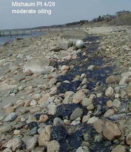
Even before this oil spill, we sometimes received queries from residents about oil on rocks or sheens that were believed to be from oil. Sometimes residents correctly identified oil pollution; sometimes they mistook naturally occurring blue-green algae on rocks, or naturally occurring compounds from the decomposition of algae. Hydrocarbon sheens in open areas might be the result of discharges from boat engines, fueling spills, or street runoff of stormwater. Naturally occurring sheens are most often found in the summer (periods of warm water), particularly in stagnant areas like salt marsh ditches, or protected pools of water, and are derived from decomposing plants and algae. Blue-green algal mats, which actually look black, occur as a thin film on rocks, generally in a one foot band on rocks above the mean high-water mark in Buzzards Bay.

To address misidentification of naturally occurring sheens from decomposing algae and plants, or blue-green algae, GEO Insight has released an algae fact sheet (121 kb pdf file, opens in new window) that addresses this issue. While the fact sheet shows a somewhat atypical looking blue-green algal mat for Buzzards Bay, overall the fact sheet is accurate. [The sharp contrasts between the algae and the rock can occur because of periwinkle grazing, but usually the boundary is on the lower edge of the algal band which represents the limit where periwinkles crawl to the waters edge to scrape rocks. Our picture to the right is a little more typical of what you might see in Buzzards Bay.]
Past Status Information and Postings from the summer 2003
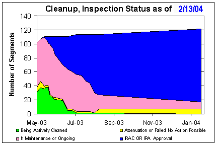
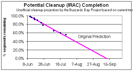
As of Sept 5, 2003 (the date of the last shoreline survey prepared by the consultant Entrix, and the last Command Center IRAC inspections), 75% of all shoreline areas had passed IRAC inspections. Most of the remaining areas were classified as either “Natural Attenuation,” “In Maintenance,” or no cleanup action was believed possible. Most of these areas were rocky areas, jetties, or salt marshes. The Natural Attenuation characterization may be used in a variety of situations where natural weathering and decomposition of the remaining oil is deemed the best course of action. Areas In Maintenance may be awaiting future cleanup action or evaluation, or may be reclassified as natural attenuation.
The maps below are somewhat misleading because although a segment may represent a mile or more of shoreline on the map, in practical terms most of these remaining segments have no visible oil except possibly a few jetties or perhaps a hundred feet of oil-painted rocks. If these small stretches of shoreline failed the IRAC inspection, the entire segment was classified as not meeting the IRAC guidelines. Existing cleanup actions are limited to very small areas. We have reinterpreted our cleanup database and simplified the figure below. We had formerly assumed that had failed the IRAC inspections were being actively cleaned, but this was not always the case. We also highlight the number of segments classified as “Natural Attenuation.”
In June we estimated noted that IRAC approvals could be completed by mid September, and progress tracked this prediction through July and August. However, it became apparent that some of the remaining difficult sites may not meet IRAC guidelines for many more months.
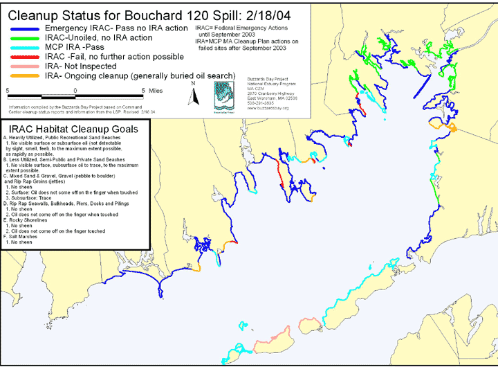
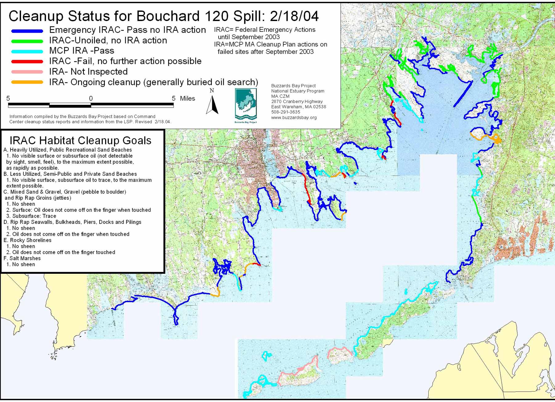
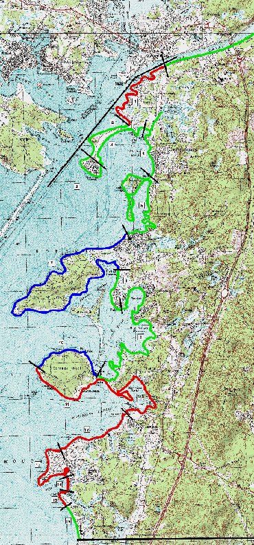
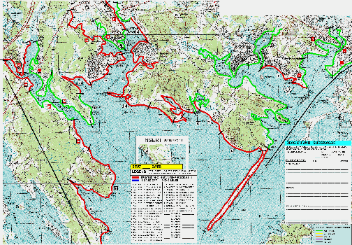
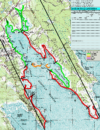
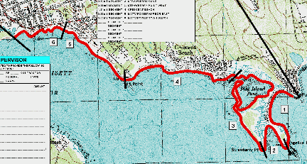
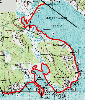
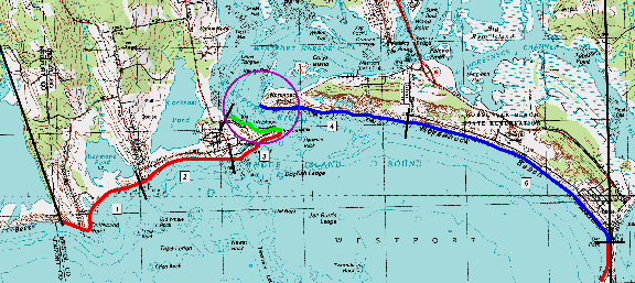
Click the map above to open a more detailed 700 kb JPG map in a separate window to show a more detailed cleanup status map. or right click here to save to your hard disk.
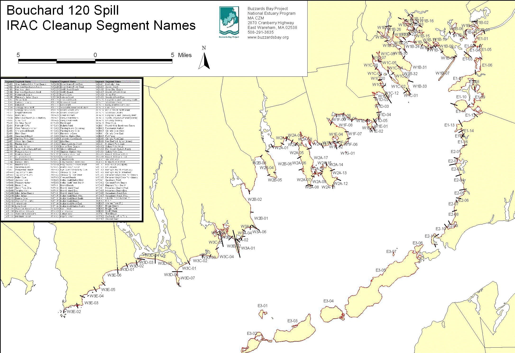
Click the map above to open a more detailed 400 kb GIF map in a separate window to show the names of all the IRAC segments. or right click here to save to your hard disk.
The emergency phase of clean-up headed up by the Coast Guard did in-fact cease in September 2003. After that point a new contractor (a Licensed Site Professional), GeoInsight, began handling the remaining cleanup under state law, with oversight by Mass DEP. Most cleanup activities ceased in 2004, with activity at a few sites continuing intermittently until 2007. In 2009, GEOInsight submitted their final report.
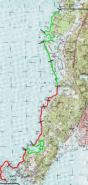
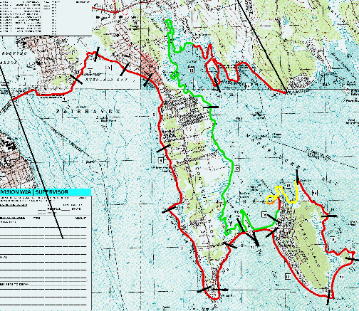
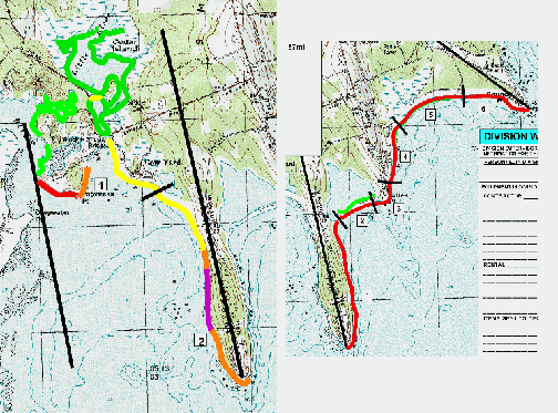
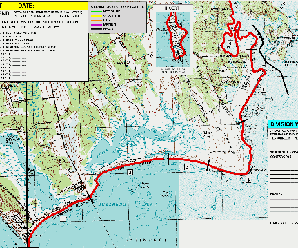
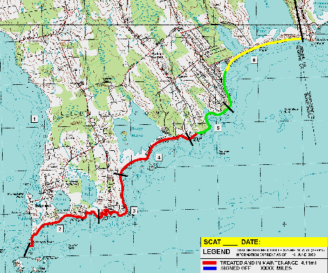
Selected June 16, 2003 Draft Maps
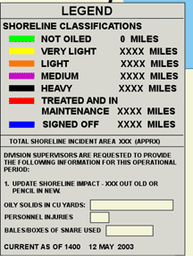
These status maps of June 16 below use the categories shown in the legend to the right. Mostly 75-150 kb GIF files. They also show the segment names referenced in the shoreline cleanup plan. They are provided to give the reader a sense of conditions and cleanup operations on that particular date.
Click here to read the June 27, 2003 Shoreline Cleanup Plan (128 kb pdf file). This was the last web based cleanup plan available.
Upper Buzzards Bay, parts of Marion, Wareham, parts of Bourne
Round Hill Dartmouth to New Bedford