Filled Wetland Atlas and Buzzards Bay Watershed Wetland Restoration Sites
Introduction
Over the course of several years, the Buzzards Bay NEP produced two companion atlases of impaired wetlands on public lands, conservation properties, and abandoned cranberry bogs which identify potential wetland restoration sites in the Buzzards Bay watershed. These atlases are the Selected Inventory of Potential Wetland Restoration Sites in the Buzzards Bay Watershed Phase I: Southern Area and Phase II: Northern Area Our work is now complete, and these Atlas are available for download on this page. They are also available in slightly higher resolution on a CD (Email us and request your free copy of the Wetland Restoration Sites Atlases on CD).
The two 100+ page reports includes maps of dozens of filled freshwater and saltwater wetlands on public and conservation lands in the Buzzards Bay watershed. Hard copy of the second volume was mailed to municipal Boards of Selectmen, and Conservation Commissions in May 2005.
This study was undertaken by the Buzzards Bay National Estuary Program (BBP) to identify potential wetland restoration opportunities in the Buzzards Bay Watershed. Of particular interest were both freshwater and saltwater wetlands that had been filled due to construction and agricultural related activities on public lands, private conservation areas, and abandoned cranberry bogs. This Selected Inventory is being produced as part of a series of Atlases, the first one being the “Atlas of Tidally Restricted Salt Marshes in the Buzzards Bay Watershed.” The salt marsh atlas identified salt marshes impaired by tidal restrictions and its purpose was to aid state and municipal officials in identifying potential remediation projects when road and bridgework is contemplated. It is hoped that these atlas will provide similar help to those government officials and local nongovernmental organizations looking for restoration projects as part of wetland mitigation efforts.
Although the BBP made considerable efforts to locate all wetland fill sites in the targeted parcels, we recognize that some sites may have been overlooked, and our list should not be considered definitive.
Interactive Maps
These interactive map files (.kmz files) show DEP core wetlands evident from aerial photographs. Actual wetland areas exceed the mapped areas, but these maps are very useful for planning, evaluating wetlands on undeveloped parcels, and for documenting legal and illegal wetland destruction. These files are quite large so we recommend downloading them to a specific directory on your computer (right click on the link, then save to a new directory e.g. “googleearth”), then opening them with Google Earth.
If you do not have Google earth downloaded on your computer, we recommend you install this free program is you want to use some of the geographic data sets we provide on our site.
Download Google Earth now to display the maps below.
All filled wetland sites considered Google Earth file
Final list of wetland sites on public or conservation land Google Earth file
Tip: In Google Earth, right click on the wetlands kmz file and change the properties of the fill so that the wetland areas are 50 percent transparent or more. You can also turn back the clock in Google Earth to look at earlier aerial photographs of the site to see if you can figure out when the site was filled.
Download Document Sections
Phase I report
[Click to open in your web browser (if capable), or right click to save to your computer. Graphics on these pdf files has been degraded to reduce file size. The CD contains the higher resolution pdf files. ]
Phase I report Cover Letter Buzzards Bay NEP Executive Director, Dr. Joe Costa. (31 KB pdf file).
- Appendix 1. Sites in Acushnet (2.1 MB pdf file).
- Appendix 2. Sites in Dartmouth (3.4 MB pdf file).
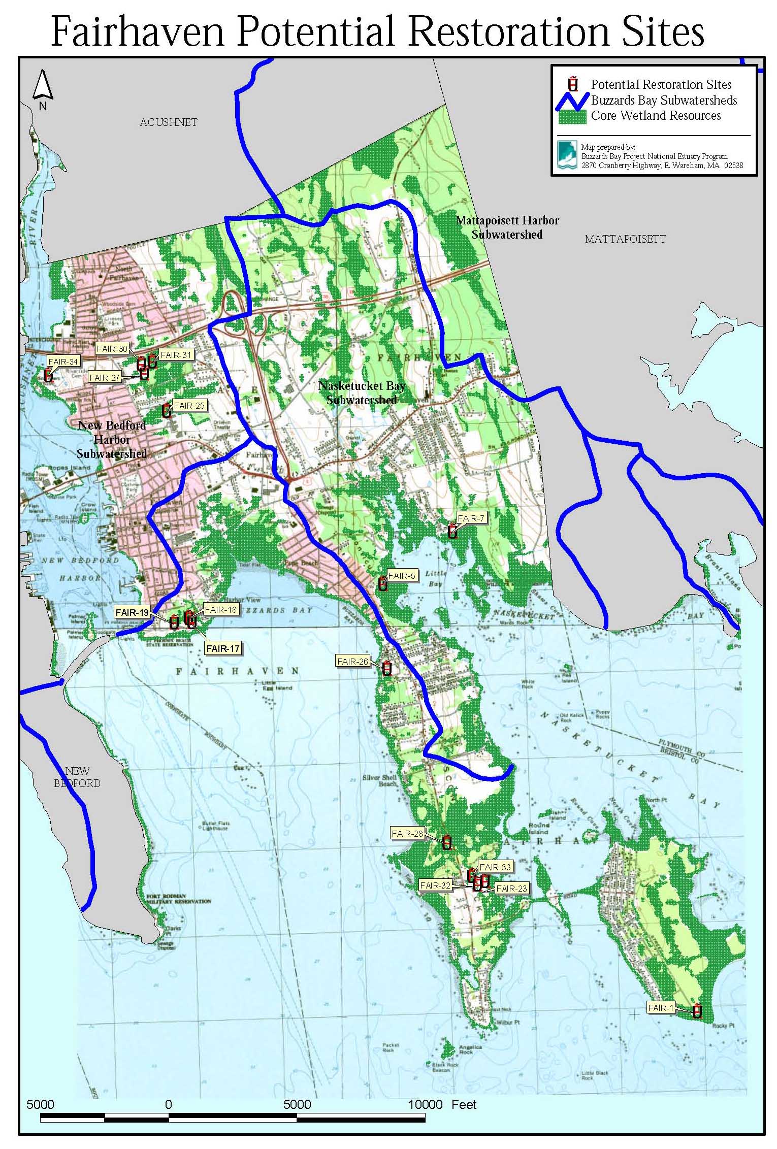
- Appendix 3. Sites in Fairhaven (3.3 MB pdf file).
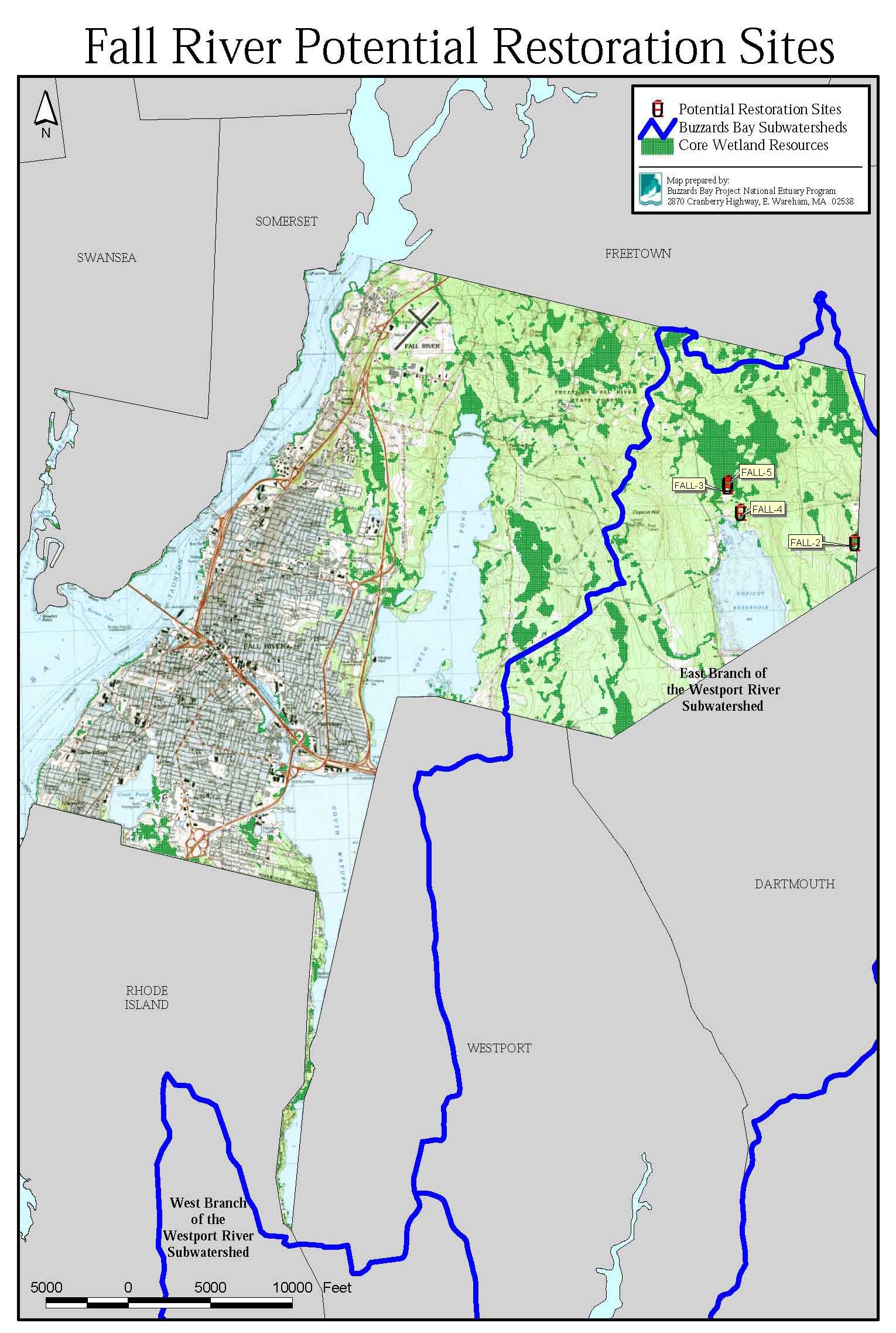
- Appendix 4. Sites in Fall River (0.7 MB pdf file).
- Appendix 5. Sites in New Bedford (2.2 MB pdf file).
- Appendix 6. Sites in Westport (2.3 MB pdf file).
Phase I report Locus Maps for Each Municipality
[These are jpg image files, about 400 kb in size. Click to open in your web browser, or right click to save to your computer.
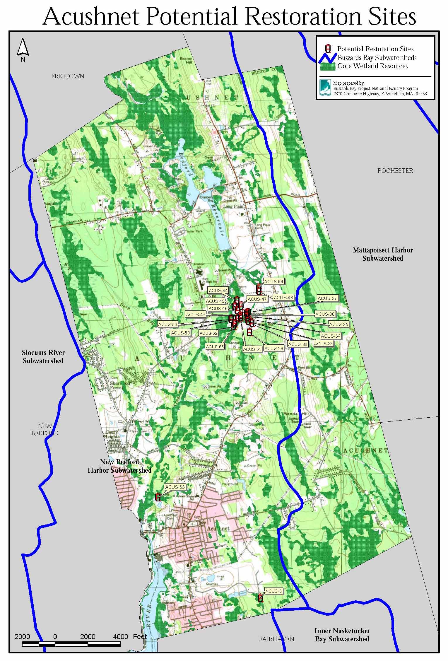
- Acushnet Locus Map
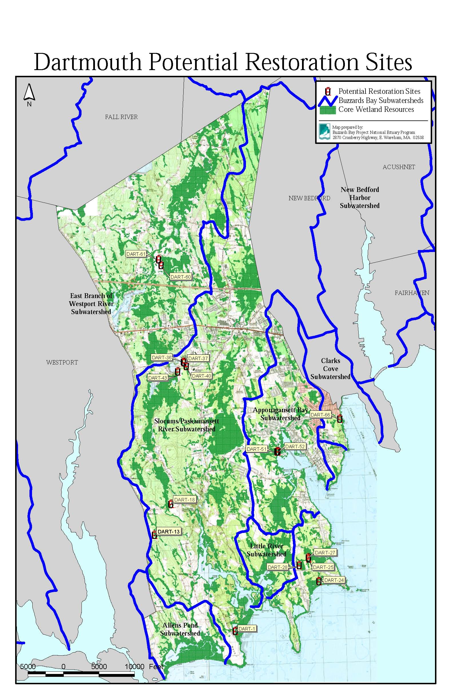
- Dartmouth Locus Map
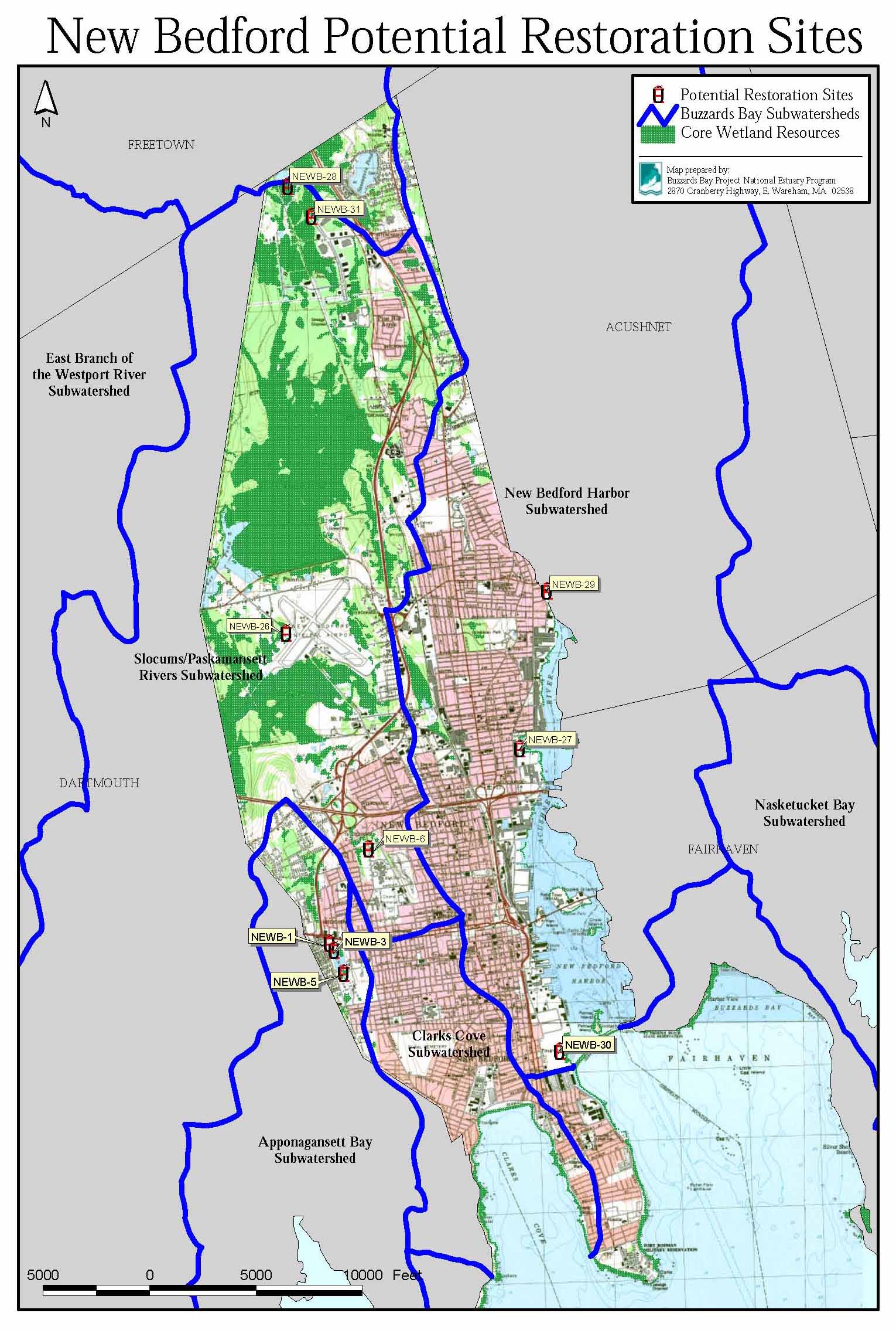
- New Bedford Locus Map
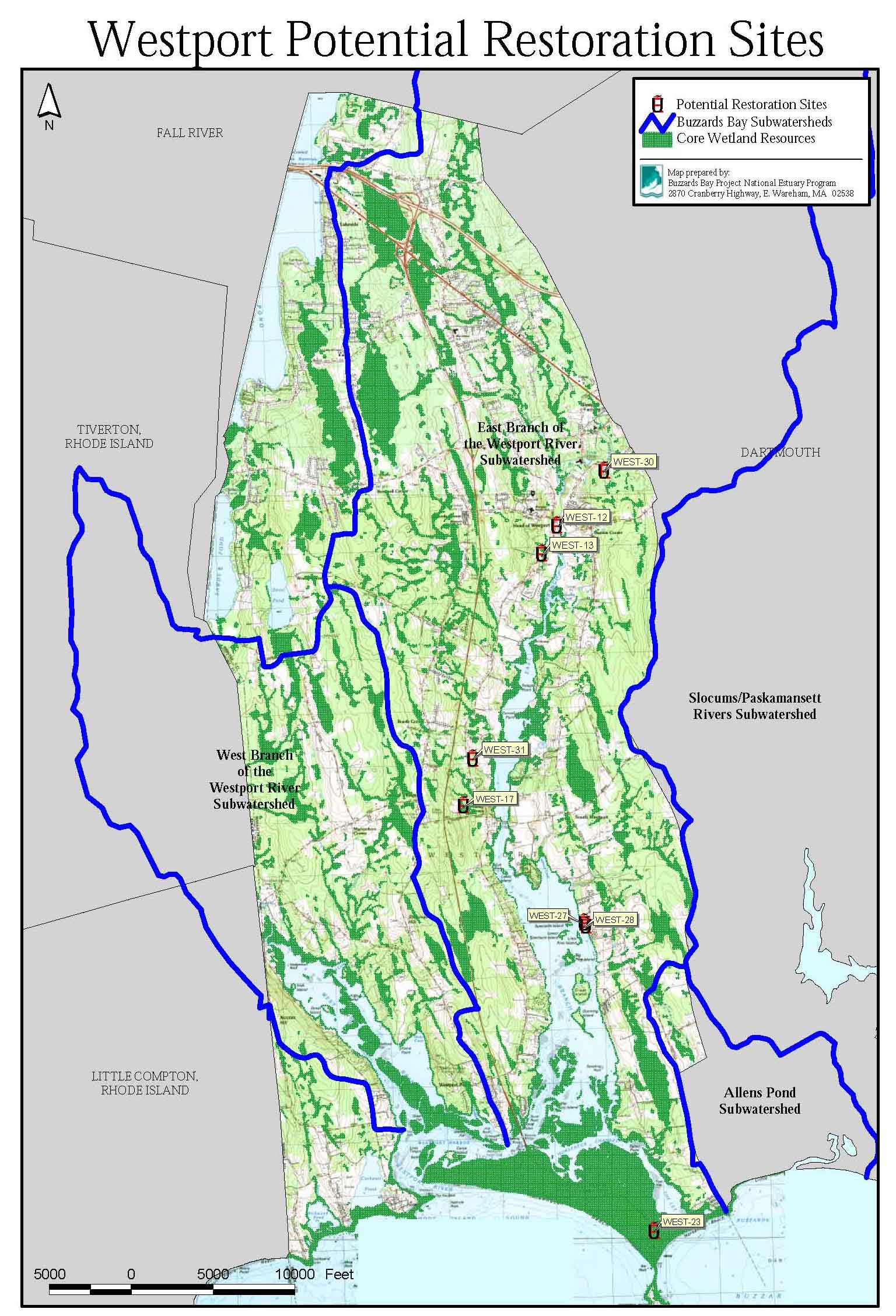
- Westport Locus Map
- Fairhaven Locus Map
- Fall River Locus Map
Phase II report
- Appendix 1. Sites in Bourne (1.2 MB pdf file).
- Appendix 2. Sites in Carver (1.6 MB pdf file).
- Appendix 3. Sites in Falmouth (0.7 MB pdf file).
- Appendix 4. Sites in Marion (3.5 MB pdf file).
- Appendix 5. Sites in Mattapoisett (1.1 MB pdf file).
- Appendix 6. Sites in Middleborough (0.5 MB pdf file).
- Appendix 7. Sites in Plymouth (1.1 MB pdf file).
- Appendix 8. Sites in Rochester (2.2 MB pdf file).
- Appendix 9. Sites in Wareham (3.7 MB pdf file).
Phase II report Locus Maps for Each Municipality
- Site Locus Map for Bourne (1.2 MB pdf file).
- Site Locus Map for Carver (1.6 MB pdf file).
- Site Locus Map for Falmouth (0.7 MB pdf file).
- Site Locus Map for Marion (3.5 MB pdf file).
- Site Locus Map for Mattapoisett (1.1 MB pdf file).
- Site Locus Map for Middleborough (0.5 MB pdf file).
- Site Locus Map for Plymouth (1.1 MB pdf file).
- Site Locus Map for Rochester (2.2 MB pdf file).
- Site Locus Map for Wareham (3.7 MB pdf file).
ArcView (TM) Files
Phase I and Phase II Wetland Restoration Sites report ArcView GIS files compressed in
filled_buzzardsbaywetlands_2004.zip
Zipped Shapefiles, Right-click to download on your computer