Eelgrass Restoration in Buzzards Bay
Localized losses of eelgrass may occur because of natural causes like storms, ice scouring, and disease. More often embayment losses are the result of declining water quality caused by nitrogen loading, or activities that suspend bottom sediments such as boat prop wash and sediment agitation by mooring chain lifting up and down on wave swells. Physical removal of eelgrass may occur from dredging, shellfishing, mooring chain scour as boats rotate with shifting winds on their moorings, or other activities that disturb the bottom.
In recent years, there have been dramatic losses of eelgrass in many parts of Buzzards Bay. Most of the losses have occurred in areas with excessive nutrient inputs, or where there have been excessive disturbances relating to boating, dredging, shellfishing, or other physical disturbances. In general, if these perturbations are eliminated eelgrass beds will naturally recover. In fact, thousands of acres of eelgrass would return to Buzzards Bay if nitrogen discharges were dramatically reduced.
Restoration through Transplantation and Seeding
In general, the Buzzards Bay NEP does not support efforts to re-establish eelgrass beds through transplantation or seeding unless two criteria are met. First, the environmental stressor that caused the eelgrass loss should be removed, reduced, or eliminated. In the case of coastal eutrophication for example, it is necessary to show that there have been appreciable reductions in nitrogen (from sewage treatment plant upgrades, sewering, etc.) to the extent that eelgrass, if transplanted or seeded, can again grow in the area of restored water quality.
Second, because of the costs of eelgrass transplantation efforts, it is important to first determine if eelgrass will naturally recolonize an area from nearby eelgrass beds. For example, in the early 1990s, after the City of New Bedford upgraded its wastewater plant and eliminated dry weather CSO discharges, there was a dramatic natural recolonization of eelgrass in Clarks Cove after a 30-year absence. In this case, eelgrass leaf wrack (including seeds) was likely blown by prevailing south-westerlies from eelgrass beds in Dartmouth to the New Bedford side of Clarks Cove to help the beds recolonize.

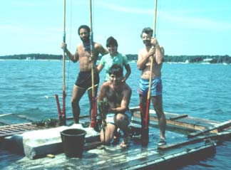
Dr. Joe Costa and crew transplanting plugs of eelgrass in peat fiber pots into a recently dredged channel in East Bay, Osterville, MA as per a DEP superseding order of conditions in the mid 1980s.
Eelgrass site selection models and their application to Buzzards Bay
A number of eelgrass site selection models and criteria have been developed by scientists that study eelgrass biology. These approaches evaluate water quality, sediment type, and consider past distribution of eelgrass beds. One recent GIS based model by Short and Burdick has gained popularity and was based in part by an evaluation of the greater New Bedford area. The Short and Burdick model creates maps with a “Preliminary Transplant Suitability Index” or PTSI.
For those wishing to evaluate all of Buzzards Bay using this approach, the Buzzards Bay NEP is providing the following GIS databases that could be used to develop a PTSI map for Buzzards Bay. One of the most important criteria when evaluating an eelgrass transplant site is to determine if eelgrass once grew there. Because of the DEP 1995 and 2001 eelgrass surveys, the Costa mid 1980s survey, and the existence of large numbers of historical aerial photographs (many of which have not yet been analyzed), this information is readily available for most of Buzzards Bay. Because of the Buzzards Bay Coalition’s water quality monitoring program, this data is also readily available, and provided her in GIS form.
Historical Eelgrass Habitat: DEP 1996, 2001 and Costa 1980s coverages combined
Buzzards Bay estimated pristine conditions habitat
Used to generate a hypothetical precolonial pristine habitat eelgrass distribution in the 2003 State of the Bay report. This is a bathymetric based coverage using the assumption that eelgrass could grow to 12 ft MLW in upper Buzzards Bay and 18 ft MLW in lower Buzzards Bay. These conditions are not dissimilar from present day areas of Buzzards Bay with good water quality. (1.9 MB zip file)
Nautical Chart Soundings
This data, taken from a NOAA website, combines bathymetric soundings data from various surveys. It can be used to create custom bathymetric contours for any portion of Buzzards Bay. (11.9 MB zip file)
Coalition Water Quality Stations 2006
This (10 kb zip file) has oxygen, nutrient, and other monitoring locations. Where there are duplicate names, use the station location defined as nutrients in the type field.
2007 Coalition WQ Data
This data, shows WQ data for each sampling date for 2007. You might want to consider taking the average of all dates and linking the water quality segment GIS coverage below to the new table you create. (120 kb zip). Data for West Falmouth stations may not be included, but will be added at a later date.
Coalition Water Quality Segments with 2007 data
In this coverage Buzzards Bay embayments were segmented based on the locations of Buzzards Bay Coalition Water quality nutrient data stations based on best professional judgment. (600kb zip file) The files is still in rough form and needs to be validated and cleaned up.