The Commonwealth of Massachusetts, through the Executive Office of Energy and Environmental Affairs (EEA), maintains a policy of Environmental Justice to better serve the environmental needs of the Commonwealth’s most vulnerable residents. EEA’s EJ Policy and Massachusetts Executive Order 552 requires that EEA agencies develop their own strategies to “proactively promote environmental justice in all neighborhoods in ways that are tailored to their agencies’ mission.” To meet these needs, in the NEP’s municipal grant program, the NEP considers whether the projects to improve water quality and living resource also benefit disadvantaged communities, as one of several criteria in reviewing grant applications.
The Buzzards Bay NEP Equity Strategy adopts the following definition of disadvantaged communities for its grant and technical assistance programs: 1) any area identified by the Commonwealth of Massachusetts Executive Office of Energy and Environmental Affairs EJ community mapping tool, and 2) any project that is either on the property of a Title 1 school (schools where at least 40% of enrollment is from low-income families), or benefits that school. Because map-based tools based on census block groups do not always capture disadvantaged communities, site specific projects within 2000 feet (walking distance) of any of these areas are considered as benefitting a disadvantaged community. Projects that benefit dispersed town-wide or region-wide disadvantaged populations (e.g., a proposal that targets low-income populations), or non-mapped communities (e.g., tribal properties), will also receive additional consideration under the NEP’s grant and technical assistance programs.
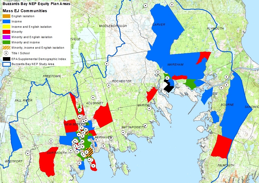
Please use the interactive map below to see areas where we seek to provide benefits under our Equity Plan using federal Bipartisan Infrastructure Law funding. Click on the “[ ] view larger map” in the upper right-hand corner of the screen below to view the map in its own window, and this will allow you to turn on other map layers like the Buzzards Bay watershed boundary and a 2000-foot buffer around features.
Map of Massachusetts EJ and EPA disadvantaged populations
Title I schools in the Buzzards Bay watershed
| Name | Town | Type |
| Abraham Lincoln School | New Bedford | Ele |
| Acushnet Elementary School | Acushnet | Ele |
| Alfred J Gomes School | New Bedford | Ele |
| Alma Del Mar Charter School | New Bedford | Cha |
| Betsey B Winslow School | New Bedford | Ele |
| Bourne Intermediate School | Bourne | Ele |
| Bournedale Elementary School | Bourne | Ele |
| Carlos Pacheco School | New Bedford | Ele |
| Carver Elementary School | Carver | Ele |
| Charles S Ashley School | New Bedford | Ele |
| East Fairhaven School | Fairhaven | Ele |
| Elizabeth Carter Brooks School | New Bedford | Ele |
| Ellen R Hathaway School | New Bedford | Ele |
| Elwyn G Campbell School | New Bedford | Ele |
| Federal Furnace School | Plymouth | Ele |
| George H Potter School | Dartmouth | Ele |
| Global Learning Charter Public School | New Bedford | Cha |
| Greater New Bedford Vocational Technical High School | New Bedford | Voc |
| Hastings Middle School | Fairhaven | Mid |
| Hayden/Mcfadden School | New Bedford | Ele |
| Irwin M. Jacobs Elementary School | New Bedford | Ele |
| James B Congdon School | New Bedford | Ele |
| James M Quinn School | Dartmouth | Ele |
| Jireh Swift School | New Bedford | Ele |
| John Avery Parker School | New Bedford | Ele |
| John B Devalles School | New Bedford | Ele |
| John William Decas School | Wareham | Ele |
| Joseph Demello School | Dartmouth | Ele |
| Keith Middle School | New Bedford | Mid |
| Leroy Wood School | Fairhaven | Ele |
| Minot Forest School | Wareham | Ele |
| New Bedford High School | New Bedford | Sec |
| Normandin Middle School | New Bedford | Mid |
| Old Colony Regional Vocational Technical High School | Rochester | Voc |
| Old Hammondtown School | Mattapoisett | Ele |
| Old Rochester Regional Jr High School | Mattapoisett | Mid |
| Renaissance Community School For The Arts | New Bedford | Ele |
| Rochester Memorial School | Rochester | Ele |
| Roosevelt Middle School | New Bedford | Mid |
| Sgt. William Carney Memorial Academy Elementary School | New Bedford | Ele |
| Sippican School | Marion | Ele |
| Thomas R Rodman School | New Bedford | Ele |
| Trinity Day Academy | New Bedford | Sec |
| Upper Cape Cod Regional Technical School | Bourne | Voc |
| Westport Elementary School | Westport | Ele |
| Westport Junior/Senior High School | Westport | Sec |
| Whaling City High School | New Bedford | Sec |
| William H Taylor School | New Bedford | Ele |
Static Map