By Joe Costa
Related Pages: B120 Shellfish Oil Spill Closures Red Tide Closures
On March 12, 2024, the Massachusetts Division of Marine Fisheries (DMF) reclassified and closed a large area around the New Bedford wastewater treatment facility outfall as per the notice posted at mass.gov/lists/emergency-shellfish-closure-and-opening-notices.
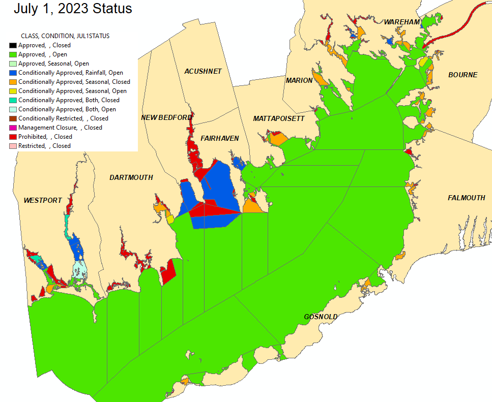
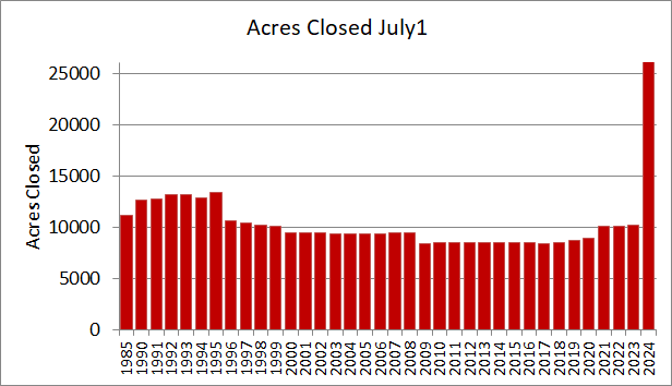
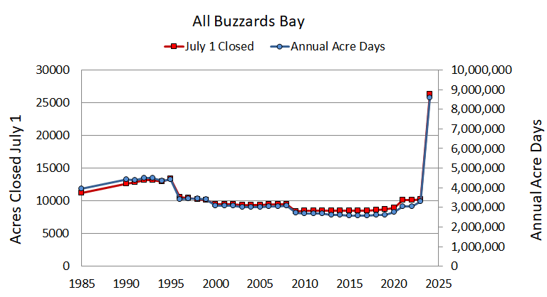
The maps and figures below show pollution-related shellfish resource area closures and status in Buzzards Bay, as of March 12, 2024, based on the new reclassifications (top), compared to July 1, 2023 (bottom). The area of shellfish beds closed on July 1 each year has been used by the Buzzards Bay NEP and Buzzards Bay Coalition for the past 30 years as a measure of bay health and an indicator of progress to reduce pollution discharges in Buzzards Bay (read the NEP’s shellfish closure analysis for the Buzzards Bay Coalitions 2022 State of Buzzards Bay report). Theses maps and calculations do not include resource area management closures for seeded areas, shellfish relay area closures, or temporary rainfall related closures (either local rainfall conditionals or bay-wide closures related to extreme rainfalls). Permanent closures are areas closed year-round. Temporary closures may be conditional “seasonal closures” or conditioned on rainfall amounts. Seasonal closures are closed typically between June and September, but in some areas, closures may extend from April to November, or longer.
The March 12, 2024, DMF notice reclassifying and redefining boundaries of prohibited (permanently closed) areas south of New Bedford, and the new expansive conditional closure area (shaded blue) stretch from the Westport-Dartmouth border to the Town of Marion, to Woods Hole and the Elzabeth Islands was the result of the DMF complying with Food and Drug Administration rules adopted in 2020. The National Shellfish Sanitation Program (NSSP) Guidance states that without modeled data or dye studies, states are required to set Mandatory Closed Safety Zones at the 1:1,000 dilution line and a conditional area within the 1:100,000 dilution line.
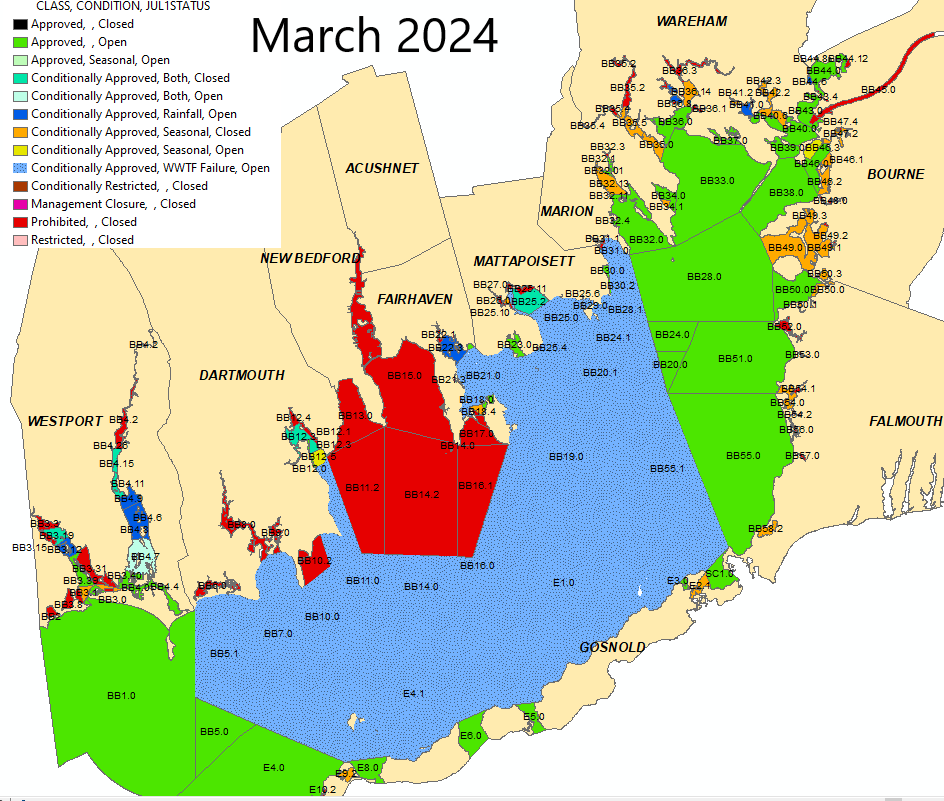
As noted on this Mass.gov webpage, DMF is required to meet NSSP requirements when classifying shellfish growing areas, particularly around wastewater treatment facility outfalls. The rules require closed safety zones around wastewater facility discharges based on specific model dilution concentrations. The sizing of the prohibited area by a 1:1,000 dilution is meant to provide a safeguard against human viral pathogens. Additional insights of effects of adopting the 2020 NSSP updated guidance are provided in this 2021 MA DMF presentation. Massachusetts is a member of the Interstate Shellfish Sanitation Conference (a state-industry-FDA partnership), and state law and regulations require that DMF follow the NSSP when classifying shellfish growing areas. Failure to comply with the NSSP rules could result in significant sanctions on Massachusetts’ interstate shipping of shellfish. The new closure lines were based on a November 15, 2023, study by UMass Dartmouth and the Division of Marine Fisheries. The new prohibited area (shaded red south of New Bedford in the 2024 map) approximately corresponds to a 1:1,000 or less dilution area. The area designated also provides sufficient notification time to close the adjacent conditional area before wastewater effluent can travel to the boundaries of the prohibited zone. The outer boundary of blue conditional area approximates a 1:100,000 dilution. This conditional closure area is triggered by a treatment failure at the New Bedford wastewater facility. The extent and duration of a closure due to a New Bedford wastewater facility malfunction under the new guidelines is longer and appreciably larger than before. When a malfunction occurred at the New Bedford WWTP on August 28, 2019, only Clark’s Cove (BB:13), New Bedford East Coastal (BB:14) and New Bedford Outer Harbor (BB:15) were closed for seven days as per this DMF notice.
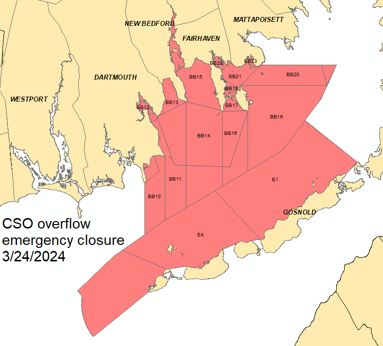
Combined sewer overflow (CSOs) discharges may also trigger a wide-spread closure in Buzzards Bay, as was the case with this March 24, 2024 MA DMF announcement (see also map below). An identical closure occurred January 11, 2024. The recent history of New Bedford CSO discharges is available at this City of New Bedford website. In the event of severe storms or exceptionally heavy rainfalls, DMF may close all of Buzzards Bay and other state waters to shellfishing.
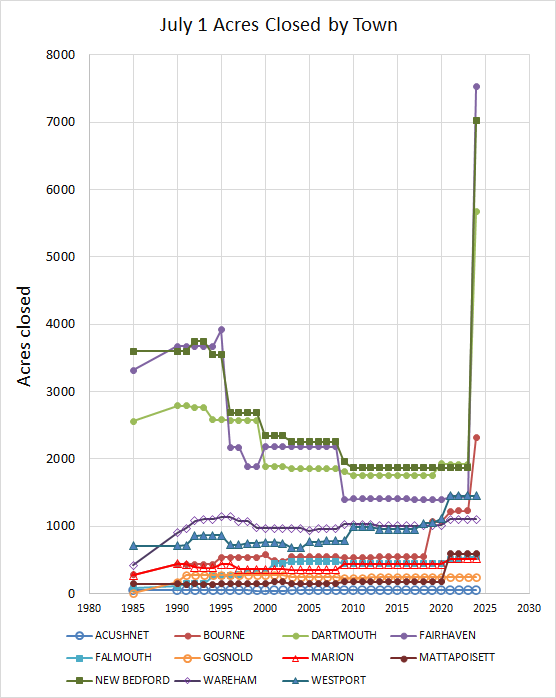
As shown in the next figure, the acreage of shellfish beds closed on July 1 in Buzzards Bay declined between 1994 and 2017. Increasing shellfish bed closures during the 1970s and 1980s was one of the principal drivers for the establishment of the Buzzards Bay National Estuary Program, and closures on July 1st are an indicator used by the NEP to track success in meeting goals of the Buzzards Bay Comprehensive Conservation and Management Plan, and by the Buzzards Bay Coalition in their state of Buzzards Bay reports. This figure does not include the Bouchard Oil spill shellfish bed closures during 2003 to 2005.
Credit: Much of the information on this page was based on data kindly provided by the Massachusetts Division of Marine Fisheries which was analyzed by the BBNEP to prepare the maps and charts on this page. Note that all of Buzzards Bay is carved into “shellfish resource areas”, but only portions of these resource areas may have commercially or recreationally viable “shellfish beds.”
2024 Closure Boundaries (interim)
Caution: This map is superseded by maps posted at town halls or notices posted at the shoreline. Download the interim 2024 data prepared by the Buzzards Bay NEP (not official, DMF has not yet posted GIS data).
Brief history of shellfish bed closures in Buzzards Bay
Throughout the 60s, 70s, and 80s, shellfish beds were increasingly being closed in Buzzards Bay due to fecal coliform contamination. As a result, keeping shellfish beds open and reopening closed beds was among the highest priorities contained in the Buzzards Bay Comprehensive Conservation and Management Plan when it was drafted in 1990. The reopening of shellfish beds during the 1990s and 2000s were the result of DMF and municipalities working together to identify and remediate pollution sources. The opening of shellfish beds in Buzzards Bay resulted from two factors: water quality improvements and in implementing rainfall “conditional closure” programs.
Several important events and trends occurred during this period. As a result of the April 2003 Bouchard No. 120 oil spill, large areas of Buzzards Bay were closed to shellfishing, and some areas of Buzzards Bay (approximately 231 acres) remain closed through 2005 (figure below). Go to our Bouchard No. 120 Shellfish bed closure page for more info. Between 1990 and 2010, the Division of Marine Fisheries reduced the geographic extent of shellfish bed closures in some estuaries to a zone around certain stormwater discharge pipes. This is illustrated by the map of closures in Buttermilk Bay below. Another important trend is that the duration of “seasonal closures” has been lengthened in many areas. Ten to twenty years ago, seasonal closures typical lasted June 1 through September 1 (or Memorial Day to Labor Day). In recent years, these closures have extended, with some closures beginning May or April, and ending October or November. This means that although the closures on July 1 have been relatively unchanged during the past few years (except for the oil spill closures), the actual acre-days of shellfish closures has increased. However, this trend has been outpaced by the total summer season closures in Buzzards Bay as per the figure below.
The expansion of the summer seasonal closures was due the extended duration of degraded warm water conditions. This decline in water quality in some cases relates to increased development near shore, increased year-round occupancy rates in some coastal vacation communities, warmer weather, and even extended occupation of harbors by waterfowl due to delayed migrations.

In the figure above, shellfish bed closures in Buttermilk Bay in 2001 and 2006 are compared. The seasonal area in Little Buttermilk Bay was eliminated and reclassified to approved except two small, prohibited areas on April 14, 2003. The prohibited area in Queen Sewell Cove and the conditional area at Hideaway Village were both reclassified to approved, except the small, prohibited classifications around stormwater discharges. Go to our Buttermilk Bay Stormwater Project page to learn more of what happened here.

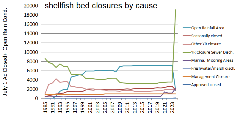
This chart above shows the annual status of pollution related shellfish resource area closures in Buzzards Bay as of July 1 of each year through 2016. The calculation of closures does not include management closures for seeded areas, shellfish relay area closures, local management closures, or temporary rainfall related closures (either local rainfall conditionals or bay-wide closures related to extreme rainfalls). The permanent closure total includes a management area in Little River, Dartmouth which is not tested or managed. In the figure, permanent closures are areas closed year-round and temporary closures are generally “seasonal closures”, mostly closed between June and September, but in some areas, closures may extend from April to November, or longer.
The reduced shellfish bed closures bay-wide between 1990 and 2017 in the figures above, were largely due to water quality improvements and reclassifications in New Bedford, Dartmouth, and Fairhaven. For towns like Bourne, Westport, and Gosnold, the picture was less rosy, with closures increasing during the same period, as shown in the town-by-town summaries in the figure below. With the March 12, 2024, reclassifications and redefinitions of shellfish growing areas, the new closures erase the gains of the previous decades.