Drift Road Stormwater Treatment Design Project
See also the engineering services procurement page for this project.
Maps and Links.
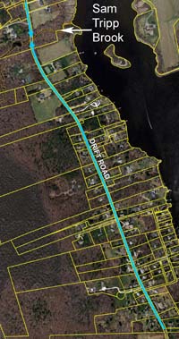
Drift Rd drainage area. This map shows the approximate flow of stormwater along Drift Road into Sam Tripp Brook (click to enlarge).
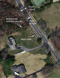
Approximate layout for a portion of Drift Rd. Towns own the road layout, which includes the paved road area and a strip of land on either side. This map shows approximate, not actual, property bounds (click to enlarge).
Aug 27, 2013 Meeting Documents
Map with property owners (pdf)
Map with detail around Sam Tripp Brook (pdf)
Presentation for August 27, 2013 Kickoff Meeting
Oct 28, 2013 Meeting Documents
Parcel plan with potential BMP sites (pdf)
Table of potential sites with photos (pdf)
These maps of potential sites is for illustration purposes only. Actual sites will depend upon the results of the test pits dug in November. No work has yet been agreed to on private property, and most work will occur in the road layout.
October 28, 2013 Powerpoint presentation.

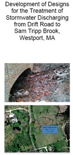
Brochure prepared for the Town of Westport (pdf)
Final Plans completed June 2014
The zipped file below contains 36 files (word and pdf documents, 20 MB) that contain plans, specifications, and information necessary to construct the proposed stormwater treatment designs that were approved by the Buzzards Bay National Estuary Program.
Overview
The Buzzards Bay NEP is working with the Town of Westport to minimize environmental impacts from a stormwater discharge on Drift Road into Sam Tripp Brook which discharges in the upper East Branch of the Westport River. In the fall of 2013, with a $20,000 grant from the Buzzards Bay NEP, an engineering firm is developing designs to reduce the volume and pollutant loading from the Drift Road stormwater runoff. In October 2013, at the request the Westport Board of Selectmen and the Westport Water Resources Management Committee, the Buzzards Bay NEP developed and printed a brochure (below right) about this project for the November 2013 Town Meeting. In this first phase of the effort, engineering designs will be developed to treat stormwater from the road. After the designs are developed, the Buzzards Bay NEP will work with the town to seek grant funds to implement the project.
Background
The volume of stormwater discharging from Drift Road into Sam Tripp Brook has increased in recent years. The higher volumes of stormwater, coupled with severe storms, led to the collapse of the Sam Tripp Brook culvert under Drift Road. While the culvert was replaced in 2012 with federal disaster relief funds, the larger volumes of stormwater continue to cause erosion along the road, dumping sediments and pollutants into the brook. The excess flows are also causing erosion of the stream banks and bottom and contributing to the overall degradation of Sam Tripp Brook. In addition, Sam Tripp Brook flows into the East Branch of the Westport River, and the pollutants from this brook contribute to the closure of shellfish beds in the upper East Branch. The Massachusetts Division of Marine Fisheries (DMF) has identified this brook as a known contributor of fecal coliform bacteria. Fecal coliform bacteria are used by DMF to determine shellfish bed closures.
In 2012, the Town of Westport applied for, and received, a grant from the Buzzards Bay National Estuary Program (NEP), a unit of Massachusetts Office of Coastal Zone Management. The purpose of the grant is to develop engineering designs to reduce the volume of stormwater discharging to Sam Tripp Brook and to reduce the concentration of stormwater pollutants affecting both the stream and Westport River.
In August 2013, Polaris Consultants, LLC was hired to develop these stormwater treatment designs. The Buzzards Bay NEP will oversee and administer the contract on behalf of the town. This work is being undertaken in partnership with the Westport Water Resources Management Committee, the USDA Natural Resource Conservation Service, and the Westport River Watershed Alliance. The design phase will be completed by January 2014.
What is the area covered by this work?
The area of stormwater contribution lies roughly between the junction of Riverside Street to the south of Sam Tripp Brook and Cardinal Lane to the north of Sam Tripp Brook. The treatment of stormwater will principally occur within the road layout. However, some property owners along the road may voluntarily participate in the effort to reduce stormwater by allowing discharges of treated stormwater on their property.
What is the road layout?
Municipalities not only own the paved surface of a town road, but they also own a strip of land on either side, in what is called the road layout. This land on either side of the road is not an easement on private property, the town owns it outright.
The photograph to the right shows an approximate boundary of the road layout and abutting properties based on maps from the town’s Assessors office. As part of this project, Polaris will survey the road layout bounds wherever construction is planned so the town knows precisely where town property ends and private property begins.
It is worth noting that property owners sometimes place plantings or maintain lawns within the road layout. This is less of a problem on Drift Road because of its rural nature. However, where property owners have made alterations within the road layout, the town will try to avoid work in these areas where possible, and will work with the property owner to address the problem.
How will the stormwater be treated?
There are various ways to treat stormwater. The approaches to treat stormwater are often referred to as Best Management Practices, or “BMPs.” In a rural area like Drift Road, water from roads is often directed into the nearby woods and away from wetlands and streams. This is typically the easiest and least expensive option. Stone is typically placed at the outlet of the discharge pipe to reduce, disperse, and slow the stormwater. The water then just percolates into the soil. This may be a strategy useful in some areas of Drift Road.

Rural BMPs: stormwater can be directed into wooded areas instead of into streams or wetlands (left) or stormwater can be directed to swales and biofilters along the edge of a road, where some of the water can soak into the ground.(right).
Where directing flow into an upland wooded area is not an option, a biofiltration swale, or similar feature can be constructed on the side of the road. This is accomplished by excavating a trench then filling it with a mixture of topsoil, sand, and compost, and planting it with grass or other vegetation. This approach will help capture, temporarily store, treat, and slow the passage of stormwater.
The best way to treat stormwater depends on the types of soil present and the depth to groundwater. To determine site conditions, this fall, the Westport Highway Department will dig test pits along Drift Road to evaluate the soils.
Who will pay for the construction of the stormwater treatment designs?
The Town will work with state and federal agencies to obtain grant funds to pay for the construction of the final designs. Often match is required for these grants, and the Town hopes to meet these match requirements by providing in-kind services by the Town’s Highway Department in installing some of the treatment systems.
What can homeowners do to help?
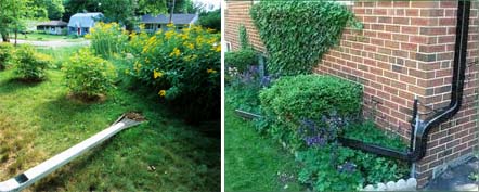
One of the major contributors of stormwater runoff to any street drainage system is from the impervious surfaces (roofs, driveways, patios) from individual house lots. Disconnecting these impervious surfaces reduces the impact stormwater has on downstream resources – in this case Sam Tripp Brook and the East Branch of the Westport River. Disconnecting can be as simple as redirecting your roof downspouts to your lawn or garden area, or to a drywell or rain barrel. There are many inexpensive solutions as shown by the photographs. Garden and building centers can provide you with the materials you need.
Although somewhat more expensive, disconnecting your driveway from the road drainage system can make the biggest impact. This could be done when your driveway needs resurfacing. Redirect the water to a lawn area or a rain garden. The stormwater will soak into the ground rather than flow onto the town road.

If your roof downspout flows into your driveway, which then flows into a town road, consider redirecting the downspout flow into your garden or a wooded area. Your effort will help the town to better manage stormwater pollution.
Schedule
This project was completed in July 2014.

