Using MassGIS Impervious data for Stormwater Planning with Comparisons to Other Approaches
Often planners and engineers need to estimate impervious areas in a watershed to estimate stormwater flow to calculate bacteria and nitrogen loading, or to help prioritize stormwater discharges for treatment. Some municipalities have digitized building footprints and other impervious areas on each parcel, and where this data is available, provides an excellent basis for calculating impervious area. Most municipalities, however, do not have this data available.
There are several different approaches for estimating impervious area on a parcel when direct parcel measurements are not available. The Buzzards Bay NEP has been using the MassGIS 2007 Impervious Surface coverage as a planning tool to estimate impervious areas to calculate stormwater flow and potential bacteria and nitrogen loading, and help prioritize stormwater discharges for treatment. On this page, we describe a step-by-step process to manipulate the MassGIS impervious cover so that the data is more meaningful. The steps below were conducted with ArcMap with an ArcView license. In this example, we use MassGIS EOT road coverage to calculate road area, and the MassGIS impervious surface coverage just to calculate the impervious cover on non-right-right-of-way parcels. We also compare this approach to using Assessors data and other GIS data sets.

Using Assessor’s data
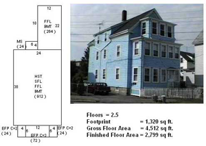
Prior to direct GIS measurements of impervious area, a rough approximation of impervious area could always be approximated using assessors data. While Assessors may have cards that show a plan view of the building with dimensions that can be used to calculate footprint area (and these plans may and available on line), the actual building footprint size is not generally recorded in Assessors databases. Instead, Assessors generally record in their database the number of stories in a building, and its total or gross building area (which typically is the total of all floors and basement and attic areas) and total finished area, which excludes closets and unfinished basements and attics (see figures below).
Because Assessors databases often includes numerous assumptions about a property (not all properties are inspected), and because it excludes covered porches, finished and gross areas can only approximate actual impervious footprint based on the statistical relationship of numerous properties. These relationships may vary depending on age of development, size of parcels, and between commercial and residential properties.
Preliminary Steps
The MassGIS impervious cover exists as a raster data set. This data was first converted to a polygon coverage in ArcMap, then clipped to the Wareham watershed, then dissolved to a single multipart feature. We also downloaded the MassGIS 2009 EOT Planning Roads coverage. This coverage is used as both a comparison tool, and as a mechanism for cutting out road impervious cover from parcel non-road coverage (roofs, driveways, and parking lots).
The 2009 MassGIS EOT road coverage was clipped to the Wareham River watershed and modified as follows:
a) Zero (0) value surface width roads, which represented just a few percent of the coverage, were assigned a width of 20 ft (new field (SURF_WID2). These zero width roads represented incomplete information in the data set and occurred in developed urbanized and lesser developed roads. The 20 ft width was based on the average width of all documented roads (20.3 feet, rounded to 20 ft), and the 20 ft width was assigned to these undocumented segments.
b) A new field HALF_WID_M was added which equaled half the road width converted to meters (SURFACEWIDTH/2/3.28). The half-width field was used to create polygons to calculate exact impervious road area in watershed areas. The original watershed EOT line coverage and generated exact width polygon shapefiles are provided as: eotroads_1shed.zip and eotroads_1shed_poly.zip
Modifications to MassGIS Impervious coverage
The created polygon impervious coverage for the Wareham River watershed was then intersected with the MassGIS Land Use Cover for the watershed (dissolved to a single multipart feature by usecode). Where the impervious cover fell on certain land use types it was presumed to be roof, driveway, or parking lot or road, and in others it was presumed to be bare earth or disturbed land. Specifically, impervious cover in these categories was presumed to be bare or disturbed earth:
1 Cropland, 2 Pasture, 3 Forest, 4 Non-Forested Wetland, 5 Mining, 6 Open Land, 9 Water-Based Recreation, 14 Saltwater Wetland, 17 Transitional, 19 Waste Disposal, 20 Water, 23 Cranberry bog, 24 Power line/Utility, 25 Saltwater Sandy Beach, 26 Golf Course, 34 Cemetery, 35 Orchard, 36 Nursery, 37 Forested Wetland, 40 Brush land/Successional
Impervious cover in these categories was considered paved road or parking lot or roof:
7 Participation Recreation, 8 Spectator Recreation, 10 Multi-Family Residential, 11 High Density Residential, 12 Medium Density Residential, 13 Low Density Residential, 15 Commercial, 16 Industrial, 18 Transportation, 29 Marina, 31 Urban Public/Institutional, 38 Very Low Density Residential, 39 Junkyard (these features were dissolved to a single polygon mask coverage to clip the impervious data).
Manipulation of Impervious Cover Outside the Road Layout
Areas outside the road layout were further manipulated by deleting any individual impervious polygon smaller than 0.0015 acres (65 square feet). This technique eliminated a speckled background noise found on some land use time, but also eliminated very small detached sheds, larger vehicles, or other transient and non-transient features not normally included in impervious stormwater calculations. The polygon coverage was also visually inspected to delete or add more conspicuous errors in impervious (paved and roof) cover.
Comments and limitations
For the most part, using certain MassGIS land use categories as a mask was effective in eliminating bare areas in agriculture, beaches, pine barrens, and certain other disturbed areas in the watershed. By omitting these areas, the technique omits impervious cover of buildings on agricultural properties, but this omission constitutes a tiny portion of total impervious area in the watershed. These omissions could be rectified by selecting parcels with dwellings and zero impervious area, and setting impervious area to 3,000 sq. ft., or whatever the loading model calls for.
The field IMP_TYP was converted to “BARE” for disturbed areas, and this separate coverage could be used to calculate loading from disturbed areas if it was assumed to contribute a higher nitrogen load than natural surfaces.
The omission of impervious area in the road layout, and relying instead on EOT road area can result in underestimates of impervious in the more densely developed areas because sidewalks, driveways, and ramps continue off parcels into the road layout. In less densely developed areas, especially those with a moderate tree canopy, MassGIS impervious cover can underestimate road impervious.
Here are the files related to this exercise:
none_rd_bare_areas.zip and none_rd_imperv_areas.zip (roof, driveway, and parking).
Data Set Comparison and Other Approaches
In the table below, we compare the EOT road coverage to the impervious areas extracted and presumed as road surface for all subwatersheds in the Wareham River estuary watershed. Notice that the MassGIS impervious cover captured with an intersect of the padded-buffered EOT roads is larger than the EOT roads, probably because bare and disturbed land along the roads were captured, and because more dirt roads in the upper watershed were captured.
With respect to impervious in non-road areas (principally parcels), the results were more interesting. In nitrogen loading calculations, analysts prefer to use actual roof and parking areas in town GIS coverages, but this data is rarely available. Consequently, other estimates are used, such as the average roof on each property is 1,500 square feet, and each driveway or parking area is 1,500 square feet (obviously, this is not appropriate for commercial areas). In the table below, we identify the number of units in each watershed, and estimate 3,000 square feet for each parcel and compare this to the MassGIS impervious cover. As shown, the 3,000 square foot rule is reasonable for lesser developed areas, but in the densest residential areas, it underestimates residential, and of course in commercial and industrial urbanized areas, it may underestimate impervious by a factor of two or more.
| Comparison of data sets and methodologies | |||||||
| SUBWAT_ID | SubWatershed Name | EOT Road | Imperv: Surf Road | UNITS | Imperv: Parcel | 3000 SqFt Rule | Comments |
| 20 | Mill Pond | 130.98 | 173.54 | 1,094 | 108.12 | 75.34 | dense residential on small parcels |
| 42 | Agawam River | 78.20 | 103.60 | 1,102 | 180.73 | 75.90 | includes considerable commercial |
| 43 | Broad Marsh River | 50.27 | 70.55 | 1,220 | 154.86 | 84.02 | includes considerable commercial |
| 44 | Wareham River West | 32.48 | 42.53 | 1,033 | 63.55 | 71.14 | dense residential on small parcels |
| 32 | Wankinco R N LT10 | 27.27 | 40.37 | 5 | 19.24 | 0.34 | some new roads, and commercial facilities inflate value |
| 41 | Rose Brook | 25.35 | 37.58 | 73 | 62.34 | 5.03 | Mall, large Commercial Areas, Trailer Parks |
| 34 | Harlow Brook | 23.56 | 31.10 | 27 | 6.42 | 1.86 | |
| 2 | Agawam Reservoir S LT10 | 21.44 | 26.28 | 9 | 2.57 | 0.62 | |
| 5 | White Island Pond LT10 | 18.00 | 23.66 | 231 | 18.46 | 15.91 | dense on small parcels |
| 39 | Maple Swamp | 17.79 | 25.63 | 2 | 11.47 | 0.14 | |
| 46 | Crab Cove | 17.31 | 21.74 | 339 | 25.12 | 23.35 | |
| 40 | Parker Mills Pond | 16.94 | 25.79 | 14 | 6.84 | 0.96 | |
| 45 | Wareham River East | 15.25 | 19.37 | 317 | 28.63 | 21.83 | |
| 50 | Halfway Pond | 14.88 | 19.80 | 11 | 3.86 | 0.76 | |
| 35 | bog stream | 14.22 | 20.33 | 48 | 40.21 | 3.31 | |
| 18 | East Head Pond LT10 | 11.63 | 16.13 | 0 | 3.68 | 0.00 | |
| 31 | Wankinco R N GT10 | 11.47 | 16.22 | 126 | 20.26 | 8.68 | |
| 7 | Fawn Pond LT10 | 11.20 | 15.08 | 0 | 2.47 | 0.00 | |
| 26 | East Branch N | 10.88 | 13.35 | 0 | 1.36 | 0.00 | |
| 33 | Frogfoot Brook | 9.76 | 14.74 | 0 | 1.32 | 0.00 | |
| 13 | New Long Pond LT10 | 5.28 | 7.01 | 0 | 0.04 | 0.00 | |
| 8 | Fawn Pond GT10 | 4.97 | 6.69 | 15 | 6.43 | 1.03 | |
| 21 | Fearing Pond LT10 | 4.57 | 6.09 | 0 | 0.18 | 0.00 | |
| 25 | Little Long Pond LT10 | 4.57 | 5.44 | 0 | 0.01 | 0.00 | |
| Sum of all others subwatersheds | 48.54 | 65.18 | 74 | 15.78 | 5.10 | ||
| Grand Totals | 578.27 | 782.62 | 5,666 | 768.17 | 390.22 | ||
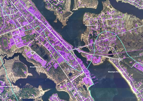
Click on the map to enlarge.
Additional detail shown in this map of impervious cover: bbnep-wareham-river-imperv.pdf
Do you have Google Earth installed on your computer? If so open these files: wareham_imperv_parcels.kmz and wareham_imperv_roads.kmz.
