Background Commuter Rail Expansion in the Buzzards Bay Watershed
In June 2008, MA Legislators appropriate funds for studies of the expansion of the Lakeville rail line to Wareham and Buzzards Bay. Read this read about it in this Buzzards Bay Commuter Rail Extension Feasibility Study. The project has languished, but periodically there is renewed interest in the project. This page contains map and information about the original proposed extension.
Purpose of this Page
There has been considerable interest about expanding commuter rail line services into the Buzzards Bay watershed. Expansion of commuter rail service can have important economic and social benefits to communities. At the same time, it is important for planners to carefully consider the locations of new lines, stations, and parking areas in order to minimize impacts to the environment, traffic, and abutting properties. Municipalities must also adopt or change their general and zoning bylaws to best encourage new development to meet their “Smart Growth” and “Low Impact Development” goals. The purpose of this page is to provide citizens, planners, regulators, and legislators with information and links about these rail expansions, so that decisions will be made that provide the greatest public benefit with the least environmental impact. Th

Background
Southeastern Massachusetts is the fastest growing region in Massachusetts, and among the fastest growing areas in the Northeastern United States. More than 200,000 new people are forecasted to move to the region in the next 20 years. Major regional transportation improvement projects, like the proposed MBTA Commuter Rail Extensions to Fall River and New Bedford, and the Rt. 3 & Rt. 24 widening (together costing more than 1.6 billion dollars), will create new growth pressures that area municipalities must address. For these reasons it is important that Buzzards Bay communities adopt comprehensive strategies to better manage new growth, particularly pollutant discharges associated with stormwater and wastewater from developed and redeveloped areas.
Existing and abandoned rail lines
Existing MBTA Commuter Rail Line Rail Line
The existing MBTA rail line is operated and managed by the Commonwealth of Massachusetts and includes Amtrak service. Detailed maps of this service are available on the MBTA commuter rail website.
South Coast Rail Project
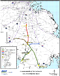
The South Coast Rail Project is an effort to restore passenger rail transportation from South Station in Boston to the cities of Fall River and New Bedford. The ongoing and lingering debate holding up this project (besides financing) is whether it is best to make this connection to New Bedford and Fall River via the Stoughton, Attleboro, or Middleborough terminuses of the MBTA commuter rail branches.
To help advance the process and receive feedback, a South Coast Rail Project website was established, but when the project did not advance, the website was taken down. There is now South Coast Rail page on the Mass.gov website.
Wareham Buzzards Bay Commuter Rail Expansion
The option of extending the existing commuter MBTA rail line that terminates in Lakeville-Middleborough, and bringing this service through Wareham and into the village of Buzzards Bay in Bourne has been repeatedly discussed. The existing rail line already serves freight trains and limited passenger service. For a commuter rail service, the railroad beds would need to be improved, and parking and terminal facilities would need to be planned, sited, and constructed. However, the costs of these upgrades would be relatively small (possibly less than $100 million, as compared to the earlier estimated 1.4 billion dollar Fall River-New Bedford expansion. Interest in this line led to the creation of the experimental Cape Cod Flyer runs during weekends in the summer of 2013. Planning is now underway to develop initial design and permit scoping for a commuter rail station in the town (read this Wareham Village Soup article about local legislators seeking to advance this process).
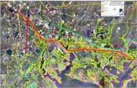
In the panel to the right is an aerial photograph showing property abutters, environmental, and physical features of the region that would need to be considered in the planning process for this commuter rail extension. Construction of public facilities in the Velocity Zone is discouraged because these areas are subject to severe erosion during hurricanes and other severe storms, however virtually none of the rail line is within the velocity zone. Most of the rail line in Wareham is in the 100-year flood plain, however structures in these areas need only meet certain building codes, and may be affected by high higher flood insurance rates. Projects in the Coastal Zone Boundary that receive federal funds require a federal consistency review by CZM.
View also:
13 Panel maps of Wareham rail abutters, superimposed on topographic maps (3.5 MB pdf file).
Map of Rochester rail abutters, superimposed on a topographic map (168 kb pdf file).
Area residents: Please take this Town of Wareham Survey and provide your feedback.

Large map of South Coast Rail Project.

Existing rail line through Rochester, Wareham, and Buzzards Bay village. Large Wareham map.XLarge print quality map (3.3 MB JPG).
Pdf version of this map (2.4 MB pdf).
Pdf version with wetlands / rare habitat (3.4 MB pdf).
Sites previously
Vicinity of Benny’s Department Store
County Road Area at Wareham-Rochester Border
SRPEDD Reports and Information
The Southeastern Regional Planning & Economic Development District (SRPEDD), located in Taunton, has established a Southeastern Massachusetts Commuter Rail Task Force page.
Cape Cod Railroad
The Cape Cod Railroad includes principally touring dinner and sightseeing train trips on Cape Cod between Hyannis and Sandwich. The railway intermittently provides service that continues from Sandwich, down along the Cape Cod Canal, across the Cape Cod Canal Railroad Bridge, into the village of Buzzards Bay. This service is typically available for the September Scallopfest in Buzzards Bay, and other occasions. Go to the Cape Cod Railroad website for more information. Some freight trains also use this line.
Waste Transfer Facility Service
A portion of the old Woods Hole Branch of the Old Colony Railroad line connects to a waste transfer station on the Massachusetts Military Reservation to the Cape Cod Canal Railroad bridge. Household waste pickup trucks from different Cape Cod communities take their waste to this transfer station where it is hauled by rail to the SEMASS waste to energy facility (operated by EnergyAnswers) in Rochester. There the trash is incinerated and converted to electricity.
Abandoned Rail Lines
Tracks of some rail lines around Buzzards Bay have been removed, covered, or converted to bike trails. The most notable of these is the four-mile-long Shining Sea Bikeway in Woods Hole, which will be extended another 10 miles along Buzzards Bay in 2008. The extended bike path will be built on the old rail bed that passes through scenic areas like Sippewissett Marsh and West Falmouth Harbor. Portions of the old rail line between Fairhaven and Marion have also been converted to a bike path.