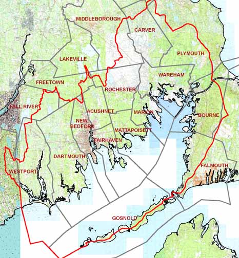
Information on Buzzards Bay Watershed Towns
|
Municipality |
Government |
Website |
Assessors Data |
|
Acushnet |
Selectboard | ||
|
Bourne |
Selectboard | ||
|
Carver |
Selectboard | ||
|
Dartmouth |
Selectboard | ||
|
Fairhaven |
Selectboard | ||
|
Falmouth |
Selectboard | ||
|
Gosnold |
Selectboard | ||
|
Marion |
Selectboard | ||
|
New Bedford |
Mayor, City Council | ||
|
Mattapoisett |
Selectboard | ||
|
Rochester |
Selectboard | ||
|
Wareham |
Selectboard | ||
|
Westport |
Selectboard |

Deed Information
Deed information for all Buzzards Bay towns is now online. Click the links below for more information.
Note on “Villages” within municipalities
Many municipalities, particularly those that did not develop large populations until after the 1960s, retain distinct village identities to sections of towns that were settled with multiple village centers in the 1600s and 1700s. This is particularly true with many Cape Cod towns. Consequently, many phone listings and mailing addresses show the name of the village, and not the name of the municipality. This phenomenon causes confusion to visitors, individuals trying to look up information or directions on the Internet, and persons looking up phone listings. The problem is exacerbated by the fact that some nearby villages have their own post offices, but neighboring post offices may have identical zip codes. This situation is not often found outside of New England. For example, if you cannot find a listing under “Bourne, MA” try “Buzzards Bay, MA” “Monument Beach, MA” or another village. Keep in mind it is possible for two villages in the same town to have identical street names!
- BOURNE: Buzzards Bay-02532, Sagamore-02561, Sagamore Beach-02562, Bournedale-02532, Pocasset-02559, Cataumet-02534, and Monument Beach-02553.
- DARTMOUTH: Nonquit, Russels Mills, Padanaram, South Dartmouth, Bayview, Smith Mills
- FALMOUTH: East Falmouth-02536, Hatchville-02536, Teaticket-02536, Waquoit-02536, North Falmouth-02556, Silver Beach-02565, West Falmouth-02574, Sippewisset, Quissett, and Woods Hole-02543
- WAREHAM: Onset-02558, East Wareham-02538
- WESTPORT: Adamsville, Westport Point
Population Overview
Below is a summary of the Buzzards Bay watershed population for the 2020 census. Census blocks bisected by the watershed were also apportioned populations based on their percent area within this watershed. This table includes all municipalities, even those with just a sliver of land in the watershed. Perhaps the most interesting statistic from this data is that 43% of Buzzards Bay watershed residents live within a 15-minute walk of the saltwater bays, harbors, or the open coast.
|
Municipality |
Town 2020 Population |
% Area in watershed* |
Population in BB watershed |
Population 1/2 mile to saltwater |
% of town shed pop near bay |
|
New Bedford |
101,079 |
96.1% |
99,132 |
44,285 |
44.7% |
|
Dartmouth |
33,783 |
100.0% |
33,781 |
7,599 |
22.5% |
|
Wareham |
23,303 |
100.0% |
23,303 |
16,144 |
69.3% |
|
Fairhaven |
15,924 |
100.0% |
15,924 |
11,963 |
75.1% |
|
Bourne |
20,452 |
83.3% |
15,346 |
10,434 |
68.0% |
|
Westport |
16,339 |
85.3% |
12,311 |
3,743 |
30.4% |
|
Acushnet |
10,559 |
100.0% |
10,559 |
2,135 |
20.2% |
|
Carver |
11,645 |
83.6% |
9,364 |
0 |
0.0% |
|
Falmouth |
32,517 |
41.2% |
8,621 |
4,824 |
56.0% |
|
Plymouth |
61,217 |
33.2% |
7,771 |
839 |
10.8% |
|
Mattapoisett |
6,508 |
100.0% |
6,508 |
3,848 |
59.1% |
|
Marion |
5,347 |
100.0% |
5,347 |
4,262 |
79.7% |
|
Rochester |
5,717 |
91.5% |
5,226 |
0 |
0.0% |
|
Middleborough |
24,245 |
24.0% |
2,038 |
0 |
0.0% |
|
Freetown |
9,206 |
13.8% |
1,689 |
0 |
0.0% |
|
Fall River |
94,000 |
27.7% |
456 |
0 |
0.0% |
|
Lakeville |
11,523 |
0.6% |
53 |
0 |
0.0% |
|
Gosnold |
70 |
52.8% |
34 |
33 |
97.1% |
|
Kingston |
13,708 |
0.0% |
3 |
0 |
0.0% |
|
Sandwich |
20,259 |
5.0% |
0 |
0 |
0.0% |
|
Total |
257,466 |
110,109 |