The Problem
Eel Pond is a salt pond near the center of Mattapoisett village in Massachusetts. It is among the most eutrophic coastal embayments in Buzzards Bay because it receives excessive nitrogen inputs, from lawns, septic systems, stormwater runoff, and an adjacent golf course. The Buzzards Bay Citizen’s Monitoring Program classifies it as having poor water quality (see the citizens water quality monitoring 2004 report).
Eel Pond has also been long closed to shellfishing due to elevated fecal coliform levels from various sources. However, few shellfish grow there because the excessive inputs of nitrogen have contributed to large areas of the salt pond having thick layers of fine anoxic mud that has the appearance of black mayonnaise. Shellfish cannot survive in these kinds of habitats.
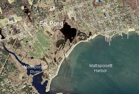
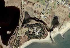
Color aerial photograph (2001) of the eastern entrance of Eel Pond.
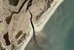
Color aerial photograph (2001) of the western entrance of Eel Pond.
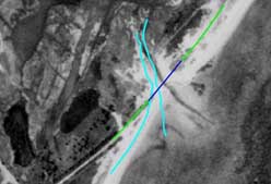
This 1971 aerial photograph of the western entrance shows the presumed location of the sewer line installed in 1977. The dark blue portion of the sewer line is armored with additional concrete. The light blue lines show the current position of the West entrance mouth. The channel has migrated roughly 53 feet west since 1971.
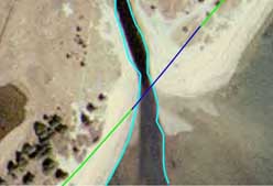
This 2001 aerial photograph of the western entrance shows the presumed location of the sewer line. The armored portion of the pipe migrated roughly 15 feet west of the low tide edge of the outlet bank.
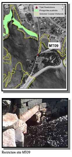
The cause of the tidal restriction to Eel Pond was the construction of a railroad bridge across the east channel more than a century ago. At that time, there was only one opening to the bay. Tidal flow to Eel Pond likely declined for years because of infill to this original channel. In recent years, further declines in flushing have helped the invasive common reed Phragmites to overtake at least 6.2 acres of salt marsh around the pond. This railroad bridge tidal restriction is listed as a priority site in the Atlas of Tidally Restricted Salt Marshes in Buzzards Bay Watershed.
A storm in the 1960s helped create the channel on the west side of Eel Pond. As this new channel has grown, the east channel has filled in more rapidly because of the slower tidal flow there.
The Town of Mattapoisett has recognized the nitrogen loading and tidal restriction issues facing Eel Pond. The town has been making slow progress to eliminate failed septic systems, and to tie in more homes into the municipal sewer system. Many problematic pollution sources remain, including stormwater runoff from roads and lawns, and fertilizer use on the adjacent golf course.
Developing a Solution
In 2005, with funding from the state legislature, the Town of Mattapoisett received funding (administered by the Buzzards Bay National Estuary Program) to develop a plan to dramatically improve tidal flushing to this nitrogen sensitive embayment. The town hired CLE Engineering to develop the restoration plan for the salt pond and the improved flushing of the east channel. This effort would improve water quality, water transparency, and create shellfish habitat by changing the characteristics of the bottom sediments. It would also help restore the salt marshes around the pond by changing the salinity and tidal inundation characteristics of the embayment, killing off the invasive Phragmites. The restoration and improved flushing was expected to slow the rate of expansion or reverse the expansion of the west channel through the sensitive barrier beach.
In 2005, as part of a preliminary assessment being conducted by the BBNEP, it was realized that the town had installed a sewer line area underneath the west channel to Eel Pond to serve the central village area. Moreover, it was further realized that the channel, which was quite small when the sewer line was installed in 1977, not only widened and deepened dramatically, but it had migrated more than 50 further west. This migration meant the channel was now migrating to a shallower and uncased portion of the sewer line. CLE’s report noted that the migration and widening of the western channel could eventually expose the sewer line, which would then be vulnerable to storm damage.
In 2006, CLE Engineering concluded their flushing study and proposed a plan and engineering designs to dramatically improve tidal flushing to Eel Pond. One component of the plan includes dredging out the recent accumulations of sand in the east channel. Another component of the plan includes the installation of a second culvert next to the railroad bridge to allow a freer tidal exchange their.
In their assessment, it was believed that the west channel could naturally close in a few years because of the appreciable long shore transport of sands along the barrier beach might block the channel. While initially it seemed reasonable to allow the eventual natural infilling of the west channel, the discovery of the threats to the sewer line had important ramifications. While the town found that the relocation of the sewer line was desirable, it would take millions of dollars and many years of planning and permitting to relocate the sewer line around the north side of the pond. This reality led the town to conclude that in the interest of public health and safety, they must actively fill in the western channel to protect the sewer line as a necessary element of the restoration effort for Eel Pond. To account for the planned closure of the west channel, CLE Engineering sized the new opening under the railroad bridge and the amount of dredging planned to ensure that the new rate of tidal flushing to Eel Pond would nearly double during spring tide conditions, even with the west channel closed.
Conclusion
The restoration and improvement of tidal flushing to impaired coastal embayments is an important strategy for restoring salt marshes, improving water quality, creating bottom habitat suitable for shellfish, and achieving recommended nitrogen Total Maximum Daily Load Limits (TMDLs) for nitrogen (see DEP’s Nitrogen Management Tools guidance). The planned work in Eel Pond is an important restoration project that could achieve all these goals. The town has included as part of their restoration effort, plans to close the relatively recently formed channel at the west end of Eel Pond. The filling of the channel is deemed necessary by the town to address concerns about the imminent potential destruction of a sewer line conveying 300,000 gallons per day. If this line were to rupture from damage received during a storm, it would create a significant threat to public health.
Links
BBNEP October 2009 review of Eel Pond water quality in response to changing hydrography.
February 2006 CLE Engineering study of Eel Pond Flushing designs.
1996 BBP-Coalition Citizen Monitoring Report (includes Eel Pond).
Excerpt of 1998 Coalition Citizen Monitoring Report for Eel Pond.
(185 kb pdf file)
Response by W. Nicholson, Sewer Department, to Horsley and Witten 1999 report on Eel Pond. (30 kb pdf file)
