Wetlands Protection: The Holly Woods Road Case
Related Pages: DEP’s Wetland Change Maps
Throughout the 1990s, the Buzzards Bay NEP believed that one of the greatest causes of wetland loss and degradation in the Buzzards Bay watershed was this misidentification of wetland boundaries by municipal Conservation Commissions through error or lack of rigorous oversight. When wetland boundaries are incorrectly identified in this way, homes, septic systems, and driveways may be sighted in wetlands and flood zones, with all too predictable consequences.
In several area communities, new developments were allowed in wetlands during the past 30 years. For some of these developments that were unsewered, septic system failure was apparent from backed up toilets and overflowing sewage in yards. Sometimes the scale of the problem was so great that towns were forced to sewer these developments at tax payer expense. The filling of the wetlands in these areas lead to worsened flooding and water quality problems downstream. The scope of the problem of local misidentification of wetland boundaries is illustrated by case below.

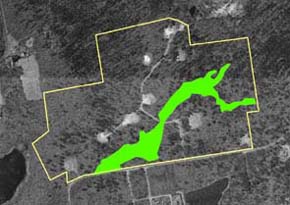
Original wetlands delineation at Holly Woods, superimposed on a 1994 aerial photograph after the construction of mounded septic systems was complete. Click on the photos for enlargements.
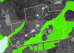
Holly Woods subdivision showing Massachusetts DEP wetland conservancy program wetland delineations based on aerial photographs. The Buzzards Bay NEP recognized these represented the minimal extent of core wetlands and would be less than actual wetlands on the site. These maps became the basis of the Buzzards Bay NEP appeal to DEP of the local RDA negative determination.
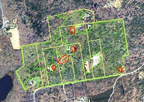
Final wetland delineation accepted by DEP and the applicant superimposed on a 2005 aerial photograph after the development was complete. Green stippled areas are bordering vegetated wetlands agreed to by all parties. Red outlined areas were wetland fill areas that were restored or permitted.
In the spring of 1993, the Buzzards Bay NEP received several calls from Mattapoisett residents about wetlands being filled by heavy equipment in a new 93-acre development known as “Holly Woods Road East.” Specifically, 6 ft tall mounded septic systems were purportedly being constructed in areas with standing water. The Project brought these complaints and other information to the attention of the Mattapoisett Conservation Commission in June, but were informed that no wetlands had been identified at the areas of construction when the permit for the work was issued three years earlier, and little could be done at this late date. Consequently, the Buzzards Bay NEP filed a formal “Request of Determination of Applicability” of the state wetland regulations to the Mattapoisett Conservation Commission notifying them that state Wetlands Conservancy Maps showed that wetlands were far more extensive than the previously approved engineering plans showed, and that the permit had in fact expired two months earlier.
Despite this new information, the Mattapoisett Conservation Commission still indicated that no wetlands were impacted or present and that no action was warranted. In an unusual move, the Buzzards Bay NEP, joined by 20 Mattapoisett residents, jointly submitted an appeal to DEP regarding the local decision.
As a result of this appeal, the state DEP conducted site visits, overturned the local decision, and issued an enforcement order for the restoration of wetlands. After the issuance of the enforcement order, the developer and engineer agreed to work with the Buzzards Bay NEP to identify wetland boundaries. Through meetings and negotiations, the developer submitted new plans to DEP that agreed with the position of the Buzzards Bay NEP that wetlands were far more widespread on the site than identified in the 1988 plans submitted by the town (compare the two maps below). Specifically, the developer agreed that 65 acres or 2.8 million sq. ft of wetlands were overlooked in the original 1988 plans.
When the Buzzards Bay NEP initiated this appeal against a Buzzards Bay community, it was criticized by many for taking such an action and second guessing a town board. For a time, attitudes of some town boards were tense toward the Project. However, when the case was settled and the outcome became known, the Buzzards Bay NEP received widespread praise for calling attention to the problem of inadequate local wetlands identification training. Today the Buzzards Bay NEP has a good working relationship with the Mattapoisett Conservation Commission and has provided assistance on several projects.
This case is also noteworthy in that it was the first case in which the Massachusetts Wetlands Conservancy maps were used as the basis for enforcement action by the Massachusetts Department of Environmental Protection.
Correspondence
The Buzzards Bay NEP wrote nine letters on the Holly Woods Road subdivision case case. Below are two key letters.
The Mattapoisett Holly Woods Road Subdivision Case (1993) -12 kb PDF.
This letter (the first of nine pieces of correspondence by the Buzzards Bay NEP) eventually led to a series of actions that resulted in a developer of a residential subdivision agreeing to redelineate the wetlands on a 90+ acre subdivision. It turned out that 65 acres of wetland were overlooked in the original wetland permit filing with the Town of Mattapoisett, and under an agreement with DEP, fill was removed from wetlands.
A 1994 update on the Mattapoisett Holly Woods Road Subdivision Case with graphics -119 kb PDF.

