Historical Eelgrass Abundance: Wild Harbor
Note: The data and maps on this page will be included in a forthcoming report summarizing changes in eelgrass distribution in Buzzards Bay. The information is posted here to facilitate review of the information, but the data should be considered to be in draft form and subject to change.
Summary
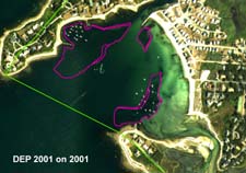
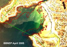
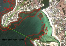
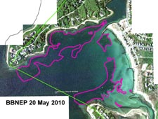
Wild Harbor is a small opened mouth embayment in North Falmouth, with the seaward bounds defined Nyes Neck to the North and Crows Point to the south. It is southwest facing, and exposed, and the shallow areas exhibit sand waves common in these higher energy environments. For this analysis, eelgrass landward of a line drawn between these two points was quantified (the green line polygon boundary in the photographs).
The long-term trends of Wild Harbor are consistent with many other Buzzards Bay estuaries, with increasing eelgrass cover through the 1960s to 1990s, with some declines post 1990. The 1950 DEP coverage appears to be over generalized and likely include bare patches (top right), and it should be reevaluated to the same scale as the other maps presented here to allow for better comparisons to that date. Areas below 12 feet in the outer harbor are not consistently imaged in the aerial surveys, so there is some doubt about the lower bed boundaries, but overall, there appears to be some loss of eelgrass in the deeper boundary areas over time, which is consistent with water quality degradation from eutrophication.
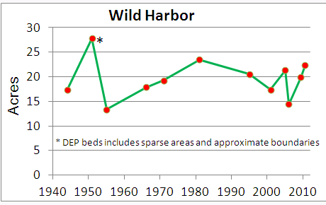
The long term trends of Wild Harbor are consistent with many other Buzzards Bay estuaries, with increasing eelgrass cover through the 1960s to 1990s, with some declines post 1990. The 1950 DEP coverage appears to be over generalized (top right), and should be reevaluated to the same scale as the other maps presented here.
Mooring Impacts
It is too difficult to discern in most aerial photographs whether Silver Beach Harbor (northeast corner of Wild Harbor) has eelgrass, but in no photo was eelgrass obviously present. This subarea also is subject to high mooring density and boating activity, and such factors may result in suppression of eelgrass there. There is slight evidence of chain scour in the mooring area at the south end of the estuary.
Previous Summaries
None available.
Wild Harbor Historical Changes and Interpretation
There are two important challenges in interpreting eelgrass changes in Wild Harbor. First, the deeper areas are not consistently imaged. In the 1996 DEP field survey (see below), eelgrass was found below the 12 ft MLW contour. This finding may have been the basis for the deep boundary presumed boundary of that bed in the 1950 aerial photograph. Alternatively, this field site may not have been well georeferenced, or the DEP defined polygon boundary was based on a small-scale image or is somewhat generalized.
Second, in high-energy moraine prominences like Nyes Neck and Crows Point, large algal covered boulders dominate the subtidal, but in deeper areas, eelgrass is typically found in sand areas between the boulders, often becoming more prevalent with depth. Because it is impossible to assign percent cover between eelgrass and algal-covered rocks in these areas, the total vegetated habitat area (except in the shallowest obvious boulder areas, which have a distinctly different appearance in the photographs) were included in this analysis Because these outer bed areas change little in area within the boundary of the analysis study area (top right, green boundary), the inclusion of these mixed eelgrass-algal covered boulder areas do not affect the trends analysis.
With respect to the 1951 DEP analysis, the boundaries as defined by DEP result in a higher estimate of bed area as compared to other more detailed maps on this page. The bed on the north side of the harbor includes has a moderate density but sparse coverage and an area that is deep (area below 12 foot contour line) to include eelgrass (compare to 1981 image below), but DEP’s 1996 field survey did find eelgrass below this depth in the outer half of the harbor (see figure below). DEP defined the eastern bed as having sparse density and patchy coverage. In any case, this coverage is generalized as the polygon areas defined by DEP are characterized as either sparse, or patchy, and thus includes bare areas, so the inclusion of the DEP data results in a spike for 1951, even though eelgrass may not be any higher or lower than the photos that bracket that date.
On the October 8, 1971 imagery (below), there appears to have been some loss of eelgrass along the west and southwestern portions of the harbor, and the beds there are much sparser there than some earlier and subsequent aerial surveys. Possible explanations for this apparent loss of eelgrass include residual effects from the 1969 fuel oil spill that greatly impacted the southwestern portion of the harbor, and tropical storm Doria, which landed in August 1971, and likely caused eelgrass bed loss in shallow exposed areas like this. However, similar sparseness of eelgrass beds due to the storm were not evident in the companion 1971 photograph for Megansett Harbor, suggesting that storm erosion allow may not completely explain the loss of eelgrass on this date. The stippled area south of the bed on the northern coast could be a mix of eelgrass and drift material, or an artifact of image processing.
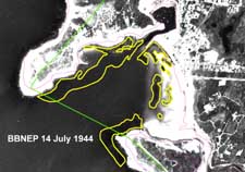
This July 14, 1944 aerial photograph shows some dense beds along beach on the northeastern shore of Wild Harbor. The beds on the north shore of the harbor are sparser than the eelgrass beds shown in summer and fall 1960s through 1980s imagery. The large bed in the southeast side of the harbor grades from very sparse to a denser core area, and the boundaries are subjective. There are also some possible sparse areas in deeper waters that are not included in the boundaries shown.
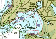
The source photo for the DEP 1951 coverage was not available, but this coverage is a somewhat simplified representation of eelgrass habitat and includes bare areas. Description fields in DEP’s data indicate that the reliability of the eelgrass bed identification is high, but that actual coverage off eelgrass in the defined area is moderate to patchy.
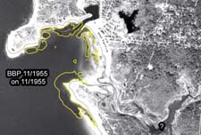 Eelgrass in this November 1955 photo is somewhat sparse. Wild Harbor is fairly exposed to storms, and the underwater sand waves somewhat dynamic, so the two hurricanes of 1954 could have damaged even deeper beds here, and this damage may have been evident in this photo taken a year after the storms.
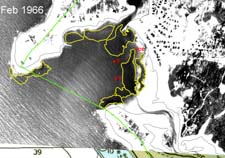 This February 1966 photograph is difficult to interpret because water transparency is poor, wave action and glare are high, and snow and ice is banked up against areas of show. Nonetheless, some eelgrass is apparent. The area for this date should be considered an estimate of the extent of eelgrass cover.
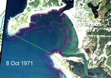
On the October 8, 1971 imagery (left), there appears to have been an some loss of eelgrass along the west and southwestern portions of the harbor as compared to the 1966 image. See text for possible explanations.
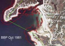
In this 1981 imagery a more robust distribution of eelgrass is evident than in the October 1971 imagery. Click on the images to enlarge.
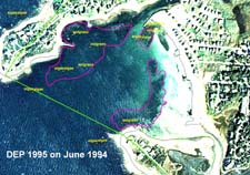
The DEP 1995 eelgrass survey plus field verification points, shown on a June 1994 aerial photograph. Click on the images to enlarge.
Variability in eelgrass cover in Wild Harbor, near the mouth of Wild River, 2007-2010. High energy environments like this may have dramatic shifts due to storms. These photographs show modest changes over a three year period, but note that the May 2010 photograph, despite taken earlier in the season that the two July photographs, shows denser and more expansive beds, particularly in the areas marked A, B, and C. Click on the image to enlarge.
