A History of Proposed Wind Farms in Buzzards Bay
Offshore Wind Turbines or “Wind Farms”
With increasing energy costs, energy and electricity generating demands, and concerns about environmental impacts associated with the transport and consumption of fossil fuels, there has been interest by all levels of government for cleaner renewable supplies of energy. One of the long discussed renewable energy options has been wind energy, and in recent years, electricity generating wind turbines have become economically competitive with fossil fuel burning plants. In some states like California and Texas, wind turbines now meet a large portion of electrical needs.
These wind farms need space, and in more heavily urbanized regions, wind farms, or arrays of wind turbines, in offshore coastal areas are being considered as viable alternatives to land based wind farms. In several European countries, large offshore wind farms have already been built. The first wind farm for Buzzards Bay (state waters) was proposed in 2002. However, as a result of proposals in Buzzards Bay and on the south shore of Cape Cod, changes in state laws, policies, and regulations effectively banned the construction of wind turbines in Buzzards Bay. This page summarizes the evebts that led to these changes.
Cape Wind
The Cape Wind project was outside of Buzzards Bay, but some of the decisions about the Cape Wind project affected turbine in Buzzards Bay, and the proposal resulted in laws, regulations, and policies that banned wind turbines in Buzzards Bay.
Cape Wind was the planned construction of 170 wind turbines in a 24 sq. mile area of Horseshoe Shoal in Nantucket Sound, in an area of federal waters nestled between Cape Cod and the Islands of Nantucket and Marthas Vineyard. The turbines would be located approximately 4 miles from Yarmouth, 5.5 miles from Martha’s Vineyard, and 11 miles from Nantucket. By the time permits were filed, the project was scaled back to 130 turbines that would produce 454 megawatts of power. The proposed turbine blade hub would stand 285 feet above sea level, with the highest blade point standing at 440 feet.
In November 2004 the project received its first favorable environmental review when the U.S. Army Corps of Engineers (USACE) released the draft environmental impact statement (DEIS) for the project. In 2005, EPA determined the Army Corps review was inadequate, and asked for more environmental information. Also in 2005, the footprint of the project was also revised when the state determined that its jurisdiction extended further into Nantucket Sound than indicated on some maps based on the existence of a small rock outcrop in Nantucket Sound visible at low tide. Cape Wind relocated some wind turbines into federal waters based on this new information.
The first state approval for the project came in May 2005 when the Massachusetts Energy Facilities Siting Board (MEFSB) approved the laying of two transmission lines in state waters. As noted in a 2005 CZMail, the Secretary of EOEA “issued a Certificate for the Cape Wind Draft Environmental Impact Report (DEIR) stating that the DEIR adequately and properly complies with the Massachusetts Environmental Policy Act (MEPA). However, the Secretary is requiring that the project proponent provide additional characterizations of project alternatives, including other locations and configurations; oceanographic modeling data of Nantucket Sound’s sediment transport pathways and how they could be affected by the project; data on the use of the Sound by birds and aquatic organisms; and an additional analysis of the visual impacts of the project. The Certificate also noted that due to a recent change to the state boundary in Nantucket Sound, some of the proposed wind turbines are planned for state waters, which would be prohibited under the Ocean Sanctuaries Act.” The Final Certificate on Cape Wind can be viewed at the MEPA website, Certificate 12643 FEIR.
On the federal level, in 2005, authority to review the project was transferred from Army Corps to the Minerals Management Service (MMS) within the Department of the Interior. The Army Corps has maintained an archive of its EIS documents at http://www.boem.gov/Renewable-Energy-Program/Studies/Cape-Wind.aspx. The original DEIS can be viewed at www.nae.usace.army.mil/projects/ma/ccwf/deis.htm. One attachment that had relevance to Buzzards Bay was the report: Technical Report for Nantucket Sound Windfarm: Evaluation of potential impacts on Roseate Tern and Piping Plover (1.7 MB pdf file).
On March 30, 2007, the Secretary of Energy and Environmental Affairs signed a certificate finding that Cape Wind’s Environmental Review “adequately and properly complies” with the Massachusetts Environmental Policy Act,” and could proceed to permitting at the state’s agencies. The MEPA filing principally covers the portion of the project in state waters, including the cable that would transmit electric power from the wind farm to the mainland, which is proposed to make landfall in the Town of Yarmouth. The portion of the Cape Wind project located in federal waters is still under federal environmental review led by the US Department of the Interior, Minerals Management Service.
In January 2008, the federal Mineral Management Service issued a Draft Environmental Impact Statement (DEIS) that determined that the wind farm would have negligible to minor impacts on the environment, navigation, and tourism. On January 16, 2009, MMS issued a FEIS, and on May 22, 2009, the Massachusetts Energy Facilities Siting Board issued an energy facility construction permit. The Federal Aviation Administration approved the construction of the wind farm on May 17, 2010. This decision was appealed but reapproved on August 15, 2012. The ACOE issued its permit on January 7, 2011. However, after the approval the project, the initiative lost several key contracts and suffered legislative setbacks. National Grid and Northeast Utilities eventually terminated their power purchase agreements in January 2015, and lease rights for the site were terminated in 2017.
Buzzards Bay Wind Farms
The first wind farm proposal for Buzzards Bay was in 2002 by the company Winergy LLC. The proposed site was off Gunning Point, in the town of Falmouth. The debate over the Cape Wind project in Nantucket Sound that was filed a year earlier had already generated a lot of interest and discussion, and the proposal for a Buzzards Bay wind farm raised concerns because the permitting, siting, and review process was unclear to many residents and municipal officials. Adding to the debate was the April 2003 Bouchard No. 120 oil spill of No. 6 fuel in Buzzards Bay. Costing more than $50 million dollars to clean up, and oiling tens of miles of shoreline, the barge was in transit to the Mirant oil burning electricity generating facility in the Cape Cod Canal.
Unlike the Cape Wind project, which was located in federal waters on land that will be leased by the federal government, the Winergy project was proposed in state waters. The state owns the land under state waters, and all the waters of Buzzards Bay are also within the jurisdiction of municipal government. This situation creates a very different set of dynamics in the permitting process for any Buzzards Bay wind proposals.
Winergy Falmouth Turbines: Application and Withdrawal
On March 25, 2003, Winergy LLC submitted an Environmental Notification Form (ENF) to the state’s MEPA (Massachusetts Environmental Protection Act) office. This was their first step in the state application and permitting process. On May 29, 2003, MEPA completed its review, and the decision by the Secretary of the Massachusetts Executive Office of Environmental Affairs required the submission of a complete Environmental Impact Report (EIR). Generally, EIRs are required for large projects like this, so the requirement was unsurprising. Like decision letters of this type, the Secretary’s letter enumerated the specific information that must be included in Winergy’s EIR. These include detailed studies of potential impacts. Completion of an EIR of this complexity by an applicant can take months to even years, and can be expensive. Typically, an applicant will apply for other required permits while preparing an EIR. However, no state permit can be issued until a MEPA EIR decision is issued.
However, at the end of July 2003, Winergy withdrew its permit for its Buzzards Bay wind turbine site in Falmouth waters. Publicly the company stated that this was due to local opposition and concerns.
Patriot Renewables LLC Proposed Buzzards Bay Wind Farms
On May 31, 2006, Patriot Renewables LLC filed this Environmental Notification Form (ENF) to construct between 90 and 120 wind turbines in three locations within Buzzards Bay. The plan is titled the “South Coast Offshore Wind Project.” The three sites are 3 to 4 miles off the coast of Sconticut Neck in Fairhaven, Barneys Joy in Dartmouth and Naushon Island, in the Town of Gosnold. The electrical generating capacity of the $750 million system is estimated to be 300 megawatts, and the electricity would enter the regional electrical grid via underwater cables entering in the Town of Fairhaven.
In July of 2006, the Massachusetts Environmental Policy Act Office (MEPA) held two public consultation and scoping sessions for the South Coast Offshore Wind Project; one in the Town of Fairhaven and one in the City of New Bedford. In its announcement, MEPA stated: “An Environmental Notification Form (ENF) has been filed for the proposed project, which will require the preparation of a Mandatory Environmental Impact Report (EIR). The project as proposed in the ENF consists of construction and operation of 90-120 wind turbine generators in the Buzzards Bay area. The project will produce up to 300 MW of renewable energy, which will be transmitted to the mainland electrical transmission system via a submarine cable interconnection to a location in Fairhaven (Egypt Lane). Permits applicable to the project include a Chapter 91 License and 401 Water Quality Certification from the Department of Environmental Protection (DEP), and a US Army Corps of Engineers 404 individual permit. The proposed project also requires a MA Coastal Zone Management (CZM) federal consistency review and an Order of Conditions from the Fairhaven Conservation Commission. The proposed project is also subject to the Ocean Sanctuaries Act.”
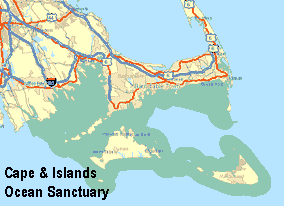
Cape and Islands Massachusetts Ocean Sanctuary Map.
On August 9, 2006, MEPA issued an ENF Certificate for this project. The ENF certificate identifies what state and local permits are required by the project and states that the applicant needs to prepare and file an Environmental Impact Report (EIR). An EIR is a comprehensive environmental impact assessment document, and the ENF certificate spells out what must be addressed in the EIR. For a project of this scope, an EIR could take many months to prepare at considerable cost. However, this ENF certificate identified a more insurmountable obstacle. The secretary stated explicitly that the project as proposed was not permittable under the Ocean Sanctuaries Act. This was not a surprising conclusion because the Ocean Sanctuaries Act explicitly prohibits “the construction or operation of offshore or floating electric generating stations” (Chapter 132A: Section 15). Because all of Buzzards Bay is in the Cape and Islands Ocean Sanctuary, and because this issue could only be addressed by a change in the law by the state legislature, this decision effectively killed the project.
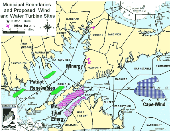
Map of proposed offshore energy facilities areas in Massachusetts prior to the passage of the Massachusetts Ocean Act.
The Massachusetts Ocean Act: A Game Changer
As noted above, in 2007, the Secretary of Environmental Affairs concluded that the 1970 Massachusetts Ocean Sanctuaries Act prohibits the construction of water-based wind farms. Because 85% of all state waters have been designated as Ocean Sanctuaries, wind farms (and tidal energy projects) were effectively banned from Massachusetts state waters. In February 2008 the state legislature decided it did not want to have such a blanket restriction of wind farms in state waters, so they passed the Massachusetts Ocean Act, effectively redefining the rules for the siting of renewable energy facilities and other activities in state and local waters. The Act resulted in two key actions. First, effective December 31, 2009, it eliminated the prohibition of siting energy facilities in Massachusetts’ Ocean Sanctuaries. Second, it required the state to adopt a Massachusetts Ocean Plan that would define allowable areas for siting energy facilities (and other activities) in state waters, along with regulations and performance standards for the siting and construction of those facilities.
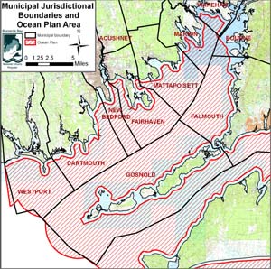
Massachusetts Coastal Zone Management developed a draft plan by June 30, 2009, and a final plan by December 31, 2009. The Ocean Plan management area is principally located between 1/3 of a mile from shore to the state-federal waters boundary (see map above). In 2011, CZM adopted supporting regulations. As noted on the CZM website, “the Massachusetts Ocean Management Plan protects critical marine habitat and important water-dependent uses and provides a management framework for ocean-based projects in Massachusetts. In response to the Oceans Act of 2008, the Executive Office of Energy and Environmental Affairs (EEA) issued the original ocean plan in 2009. The Oceans Act requires EEA to review the ocean plan at least once every five years, a process led by the Massachusetts Office of Coastal Zone Management (CZM).”
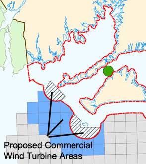
This map shows areas proposed for commercial scale renewable energy near Buzzards Bay. Proposed large scale wind turbine areas are hatched (state waters) and shaded blue (federal waters). Proposed tidal energy areas are shaded green. Taken from the December 2009 Final Massachusetts Ocean Plan Figure 2-18. Smaller community scale (<10 turbine) wind farms could still be built in other parts of Buzzards Bay
Massachusetts Ocean Plan Defined Areas
The Massachusetts Ocean Plan, a draft released July 1, 2009, and finalized on December 31, 2009, severely restricts potential locations for the siting of large commercial wind facilities in Buzzards Bay. The map above shows the designated wind turbine areas near the mouth of Buzzards Bay. With the designation of this area, projects in Buzzards Bay like the South Coast Offshore Wind Project are no longer viable. The new Ocean Plan does not preclude community small scale (<= 10 turbines), which could still be constructed in large parts of Buzzards Bay (principally in the bottom third of Buzzards Bay (see Figure 2-20 of the Ocean Plan).
State versus Federal Waters
Generally, waters within three miles of shore are considered state coastal waters. In most of Massachusetts, and for all of Buzzards Bay, these coastal waters are also within municipal corporate boundaries (see map above). For nearly enclosed bodies of water like Buzzards Bay that are wider than six miles across, there is no “hole” of federal waters in the middle, and instead the entire bay is considered coastal waters, going beyond this three-mile limit to the center of Buzzards Bay. Thus, no matter where you are in a boat in Buzzards Bay, you are actually in the waters of one of the Buzzards Bay coastal towns. Residents in coastal towns often do not realize how many municipal abutters their town truly has. In the case of Falmouth, nine municipalities abut the town’s corporate boundaries, including the western watershed towns of Fairhaven, Marion, and Mattapoisett.
Within state waters, land under the sea is owned by the state with certain privileges and authorities conferred to municipalities. Generally, municipalities control the water surface zoning and uses, like the placement of moorings. No land under the low tide mark can be privately owned, but in the case of aquaculture projects, state and municipal government sometimes lease this land. In a practical sense, anyone appreciating the differences between permitting wind farms in state versus federal waters (see below), will recognize that in the end, it is unlikely that a large-scale offshore wind farm will ever be built in state waters unless it has the support of the state Executive Branch, the state legislature, and residents and officials of the town where they would be built.
Municipal Coastal Surface Water Area Statistics
| TOWN | 2000 year-round pop. | Entire municipal area with coastal waters (sq. miles) | Land + Freshwater Pond area | Coastal Waters (sq. miles) |
| BOURNE | 18,721 | 57.28 | 41.083 | 16.20 |
| DARTMOUTH | 30,666 | 96.21 | 61.953 | 34.26 |
| FAIRHAVEN | 16,159 | 40.88 | 12.409 | 28.47 |
| FALMOUTH | 32,660 | 103.22 | 46.007 | 57.21 |
| GOSNOLD | 86 | 135.04 | 13.441 | 121.60 |
| MARION | 5,123 | 27.98 | 14.121 | 13.86 |
| MATTAPOISETT | 6,268 | 42.26 | 17.493 | 24.77 |
| NEW BEDFORD | 93,768 | 33.39 | 20.279 | 13.12 |
| WAREHAM | 20,335 | 46.35 | 37.144 | 9.20 |
| WESTPORT | 14,183 | 89.80 | 52.112 | 37.69 |
Note: Water areas for Gosnold, Bourne and Falmouth include areas of Rhode Island Sound, Cape Cod Bay, and Vineyard Sound. Population statistics and areas are town wide, not just within the Buzzards Bay watershed.
State versus Federal Permitting of Wind Turbines
A wind farm located in federal waters must comply with the various permit requirements under the Clean Water Act. Because there is no discharge to waters from windmills, in a practical sense this means they only require a federal wetland filling permit, issued by the US Army Corps of Engineers. This permit focuses only on wetland-related impacts. The Cape Wind project in central Nantucket Sound is considered to be in federal waters. (Because of its semi enclosed nature, some believe Massachusetts may have some rights over Nantucket Sound, although it is more likely federal legislation would be required to change the state-federal jurisdictional boundaries.)
On the other hand, a wind farm project in Buzzards Bay (i.e. in state and municipal waters), must comply with all state and local permitting, and now must also be consistent with the Massachusetts Ocean Plan, and any supporting regulations. In state coastal waters, a federal Army Corps wetlands permit is still required for these types of projects, and Army Corps is not bound to any performance standards or regulations in a state plan. In fact, it is possible for the state to approve a project and the federal government to deny a project, and vice versa. Local permits are still required and include a state Wetlands Protection Act permit (issued by the local Conservation Commission, but appeals of local decisions are reviewed by MA DEP), a state Chapter 91 Waterways License (which considers navigation and public access issues). Also required is an approval by the Executive Office of Energy and Environmental Affairs under the Massachusetts Environmental Protection Act (MEPA). The MEPA filing will likely be the principal mechanism for ensuring consistency with the Massachusetts Ocean Plan.
One of the most significant remaining obstacles to allowing offshore energy facilities is the Chapter 91 waterways license requirement. Chapter 91 regulations currently have an explicit prohibition against construction on submerged tidelands that is not “water dependent” (that is principally relating to fishing, fowling, and navigation). It is expected that once EEA approves the new Massachusetts Ocean Plan, DEP will promulgate new Chapter 91 regulations making allowances of wind and tidal energy facilities. A Chapter 91 permit is the only environmental permit that explicitly requires the signature of the Governor.
Approval of any one of the aforementioned permit applications is exclusive and independent of the others. Either the applicant or an aggrieved party can appeal these permit decisions as allowed under the relevant laws and regulations. Because the state government owns the land, there is no constitutional “takings” issue if a project is denied.
Special Considerations for Buzzards Bay
The Massachusetts Ocean Plan effectively precluded the construction of Wind Turbines in Buzzards Bay. Two aspects of Buzzards Bay have strongly affected the evaluation of various activities allowable in Buzzards Bay under the Ocean Plan. First, one half of North America’s breeding pairs of the Roseate terns (Sterna dougallii) can be found on two tiny islands. The EPA classifies the species as endangered. Over the past two decades, considerable effort has been put into the study and management of this population. Go to our Roseate tern page for more information about this effort.
Second, Buzzards Bay is part of the Atlantic Intracoastal Waterway system and is an important recreational and commercial boating area. As noted on our Bay and Watershed Information page, more than 12,000 boats can be found moored or on Buzzards Bay during peak summertime holidays.
Buzzards Bay is connected to Cape Cod Bay by the Cape Cod Canal. The 480-foot-wide Cape Cod Canal is the world’s widest sea-level canal, and it has a navigable depth of 32 feet at mean low water. As noted on the Army Corps Cape Cod Canal website, more than 20,000 vessels pass through the Canal annually. Many of these vessels are smaller recreational vessels, but in a busy 24-hour period, perhaps 20 to 30 larger transport vessels including tankers, barges, tugs, ferries, fishing vessels, container vessels, cruise ships, and other transport vessels pass through the canal. Other vessels entering Buzzards Bay bring cargo to New Bedford Harbor, which also is home to one of the largest fishing fleets on the east Coast, with approximately 270 vessels.
These and other considerations resulted in the prohibition of wind turbines from nearly all of Buzzards Bay in December 2009.
Land Based Wind Turbines
In contrast to siting wind turbines on the water, land-based wind turbines remain considerably easier to permit than offshore turbines, but the permitting process has become more restrictive over time. In April 2006, the first wind turbine in the Buzzards Bay watershed was built at the Massachusetts Maritime Academy in the village of Buzzards Bay in the Town of Bourne, MA. When this 2/3-megawatt facility went online in the summer of 2006, it was projected to save the Academy $300,000 annually in electric costs. The Town of Falmouth placed a wind turbine at its wastewater facility in West Falmouth, to not only power the facility, but also earn the town additional revenue in selling excess power production. Other municipalities and universities in the Commonwealth are considering building their own turbines.
Standard Times Newspaper article 7/24/06: MMA shuts turbine for avian study.
As more land-based wind turbines were built, there may be an increased public awareness and support for these structures. However, controversies have arisen related to the siting, permitting, and potential health concerns relating to two large turbines (1.7 MW, 402 feet tall) in Falmouth have been widely watched by other communities in the region, and has led to several municipalities, and the Cape Cod Commission adopting regulations setting limits on the size of these turbines, and their proximity to development. The articles below summarize some of the issues relating to the siting and abutter concerns to these facilities.
Because of abutter complaints to these turbines, several municipalities, and the Cape Cod Commission adopted regulations setting limits on the size of these turbines, and their proximity to development.
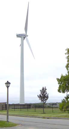
Massachusetts Maritime Academy Wind Turbine near the village of Buzzards Bay in the Town of Bourne.
Underwater Turbine System Proposed for Vineyard Sound
An underwater turbine system has been proposed by the Massachusetts Tidal Energy Company of Washington, DC. On April 17, 2006, the company filed with the Federal Energy Regulatory Commission for a preliminary permit for the venture, called the Cape and Islands Tidal Energy Hydroelectric Project. The turbines would be located underwater, and water currents would drive a turbine system. This work appears to be in the study and evaluation phase, and because the area is in state and local waters, local and state permits would be required before any such facilities are constructed. Information about the project was posted in the May 25, 2006 Federal Register and at FERC elibrary information on docket P-12670.
