Buzzards Bay Climate Data, Historical Records, & Precipitation
Related Pages (Including Climate Change): climate.buzzardsbay.org StormSmart Coasts Flood Zone Expansion with SLR | Salt Marsh Expansion with SLR Hurricane & Storm Info | King Tides | New CCMP Shifting Shorelines Action Plan
Sunrise – Sunset
Sunrise & Sunset for Southern New England from NOAA
Precipitation
NOAA seasonal prediction for US temperature and precipitation
NOAA’s Interactive Historical Weather Records for all sites
Data can be emailed to you for free.
NOAA’s “unofficial” recent records for Massachusetts Cities
(Data is free, but not error checked [e.g., daily rainfall sometimes not recorded]. Great if you need to look up a specific month and year for a Massachusetts location.)
Drought.gov info for Massachusetts (federal status)

Last months percent of monthly rainfall map


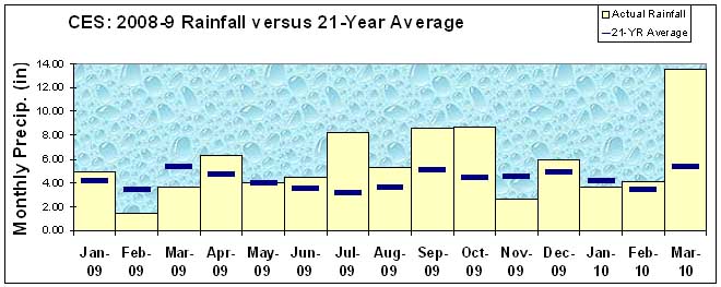
2009-10 rainfall in Wareham versus 20-year average. Data from the Cranberry Experiment Station.
Data from Cranberry Experiment Station Courtesy of Caroline DeMoranville. Compiled and analyzed by the Buzzards Bay NEP.
21 year statistics
For the period October 1, 1988 to October 1, 2009 (21 years), the following statistics were calculated from the UMass Cranberry Experiment Station:
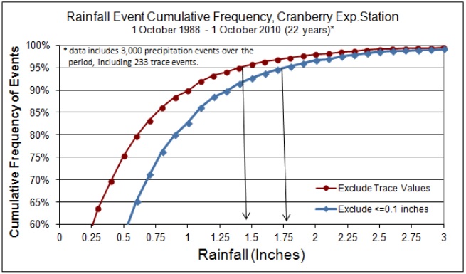
For daily (24 hr) rainfalls, the max daily rainfall was 5.27 inches, the minimum monthly was 0.21 inches (August 1993), the max monthly was 14.78 inches (September 1996), and the max yearly was 64.78, the min yearly was 39.51 inches, and the annual average including trace amounts (presumed =0.005 inches) was 50.66 inches. On average, each year had 229 days with no rain and 136 days with some rain, of which 126 days had measurable rain. Of the days with rain (including trace), 90% of the rainfalls were 1.02 inches or below, and 95% of the rains (with trace events included) are 1.42 inches or below. However, if you consider only rainfalls likely to generate stormwater (typically more than 0.1 inches, or dropping 1/3 of all measurable rain events), then the 95th percentile is 1.72 inches in Wareham. Values for “storms” (i.e. greater than 24 hours of rain) are considerable higher.
| Year | J | F | M | A | M | J | J | A | S | O | N | D | total |
| 1989 | 1.79 | 3.19 | 4.21 | 5.89 | 4.60 | 3.26 | 5.47 | 6.00 | 5.23 | 4.82 | 7.07 | 0.51 | 52.01 |
| 1990 | 6.36 | 3.46 | 2.66 | 5.23 | 5.94 | 1.45 | 4.57 | 1.72 | 3.89 | 4.73 | 1.67 | 5.33 | 46.99 |
| 1991 | 3.70 | 2.17 | 7.36 | 4.17 | 2.57 | 2.07 | 2.25 | 3.63 | 8.15 | 3.28 | 6.93 | 3.55 | 49.81 |
| 1992 | 2.69 | 2.60 | 4.44 | 2.65 | 0.91 | 4.40 | 3.16 | 5.83 | 4.49 | 2.22 | 4.63 | 10.55 | 48.55 |
| 1993 | 2.57 | 4.19 | 6.10 | 4.84 | 1.45 | 1.50 | 2.15 | 0.22 | 3.36 | 4.90 | 4.30 | 7.07 | 42.61 |
| 1994 | 5.50 | 4.12 | 7.89 | 2.98 | 3.80 | 4.42 | 0.85 | 4.80 | 2.97 | 1.16 | 5.35 | 6.69 | 50.50 |
| 1995 | 3.34 | 2.60 | 3.20 | 2.57 | 3.19 | 3.07 | 2.96 | 1.44 | 2.93 | 7.56 | 7.23 | 2.74 | 42.80 |
| 1996 | 5.26 | 3.53 | 3.51 | 5.79 | 3.33 | 1.36 | 4.09 | 3.97 | 14.78 | 9.35 | 2.18 | 6.87 | 63.99 |
| 1997 | 3.11 | 2.20 | 5.10 | 5.64 | 3.52 | 1.84 | 4.10 | 6.46 | 1.37 | 1.86 | 6.03 | 3.27 | 44.48 |
| 1998 | 8.01 | 8.36 | 5.89 | 5.57 | 4.81 | 8.89 | 2.93 | 5.17 | 1.75 | 3.45 | 2.33 | 1.13 | 58.29 |
| 1999 | 5.55 | 3.55 | 4.66 | 1.16 | 4.21 | 0.63 | 1.74 | 3.01 | 5.23 | 4.63 | 3.06 | 2.15 | 39.56 |
| 2000 | 3.94 | 3.63 | 6.60 | 7.35 | 4.74 | 2.88 | 3.79 | 3.15 | 3.04 | 2.66 | 3.33 | 4.07 | 49.16 |
| 2001 | 2.37 | 2.62 | 13.57 | 2.68 | 4.13 | 5.63 | 3.85 | 4.20 | 3.80 | 1.01 | 0.66 | 3.52 | 48.02 |
| 2002 | 3.58 | 2.29 | 4.65 | 4.73 | 5.25 | 4.12 | 1.55 | 1.09 | 6.46 | 3.03 | 6.50 | 8.58 | 51.81 |
| 2003 | 3.14 | 5.60 | 7.21 | 6.89 | 3.26 | 5.45 | 2.17 | 2.83 | 2.38 | 5.25 | 2.97 | 5.99 | 53.12 |
| 2004 | 1.81 | 2.42 | 1.98 | 5.54 | 2.81 | 1.66 | 2.73 | 6.48 | 5.38 | 2.01 | 4.28 | 4.64 | 41.73 |
| 2005 | 4.87 | 2.80 | 7.03 | 4.17 | 8.14 | 1.03 | 1.02 | 4.10 | 6.91 | 12.07 | 5.79 | 3.20 | 61.11 |
| 2006 | 7.02 | 2.38 | 0.59 | 2.13 | 7.14 | 12.15 | 1.50 | 3.06 | 4.89 | 4.68 | 6.24 | 2.85 | 54.62 |
| 2007 | 4.05 | 1.93 | 6.54 | 8.13 | 2.99 | 1.77 | 3.77 | 1.10 | 1.32 | 3.26 | 4.94 | 6.11 | 45.90 |
| 2008 | 2.62 | 5.73 | 5.27 | 4.56 | 2.81 | 2.87 | 3.41 | 2.85 | 9.83 | 2.37 | 5.68 | 6.75 | 54.75 |
| 2009 | 4.97 | 1.44 | 3.58 | 6.24 | 4.03 | 4.41 | 8.23 | 5.34 | 8.54 | 8.66 | 2.66 | 5.92 | 64.01 |
Cumulative Rainfall Frequency
The Buzzards Bay NEP has promoted for new construction certain US EPA federal standards promulgated in 2009 for sizing stormwater treatment systems on federal properties. The 2009 Section 438 standards (read the Section 438 technical guidance require that stormwater practices retain the 95th percentile storm. The recommended methodology for this calculation is to exclude rainfall events that “are 0.1 of an inch or less” from the “percentile analysis because this rainfall generally does not result in any measurable runoff due to absorption, interception and evaporation by permeable, impermeable and vegetated surfaces.” The federal guidance also notes “at least a 20-30 year period of rainfall record is recommended for such an analysis.”
The Buzzards Bay NEP analyzed precipitation data for East Wareham collected by the UMass Cranberry Experiment Station that was available for the past 22 years to calculate the 95th percentile storm. There are 3,000 24-hr rainfall events for this 22-year record, but 232 of these are “trace” measurements, with no numeric value recorded. Including these trace rainfalls in the analysis, the 95th percentile rainfall is 1.40 inches. Excluding these trace events (as is typically done to define storm size storms for regulations), results in a 95th percentile rainfall of 1.45 inches. However, there are 1,020 events for this 22 between trace rainfall and up to and including 0.1 inches (1/3 of all measurable rain events). Discarding these events, the 95th percentile is 1.72 inches in Wareham. While this is a tough standard, it will capture for treatment a greater percentage of annual rainfall as described below.

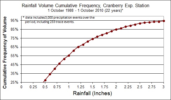
When considering mass loading of pollutants from stormwater, an equally important consideration is the annual volume that is not treated by the stormwater system. While it may be the case that 75% of all 24-hr rainfalls are less than a half-inch, these rainfalls account for only 27% of the annual total precipitation volume as per the figure below.

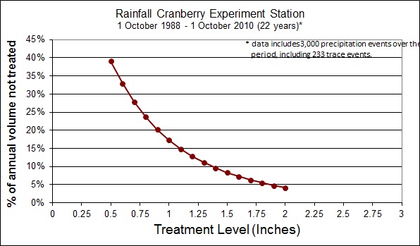
To calculate the volume of annual precipitation not treated by a stormwater system is a little more complicated, because you must subtract the treatment volume from the total 24 hour rainfall of all the heavier rainfalls. For a system that treats only the first half inch, it turns out that that 39% of our annual rainfall of 51 inches will not be treated. In the figure below are the percent annual precipitation volumes not treated by systems with different volumes of treatment. This analysis ignores the presumption that the “first flush” of stormwater contains the greatest pollutant load in stormwater, and this factor must be considered when calculating net pollutant remove from any particular installed design.

Climate
Woods Hole Oceanographic Institution Historical Climate Data (solar rad, temp, precip)
Groundwater and surface Water Data
USGS’ Massachusetts Climate Response Network page
Great site, just click on the map to obtain historical average groundwater elevations for long term monitoring well sites.
USGS Surface Water Levels Data retrieval page for Massachusetts
Groundwater Levels: Historic and Recent for two sites
Click on the links for data and graphs.


Stream Flow
USGS’ Water watch page
Click on the map to obtain real time stream monitoring data.