Buzzards Bay Quick Facts
Buzzards Bay is a moderately large estuary located between the western most part of Cape Cod, Southeastern Massachusetts, and the Elizabeth Islands. The bay is 28 miles long (45 kilometers), averages about 8 miles (13 kilometers) in width and has a mean depth of 36 feet (11 meters). The definition of the southern boundary of the bay varies with different jurisdictions and agencies. The bay and its estuaries total approximately 233 square miles (603 square kilometers) if using an older nautical chart definition of Buzzards Bay, which is a line from the tip of Gooseberry Point, Westport to Cuttyhunk Island, with the waters further south typically labeled Rhode Island Sound. For management purposes, however, Massachusetts state agencies include the Westport Rivers in the Buzzards Bay watershed and draw a line defining the bay from the Rhode Island – Massachusetts border. The Buzzards Bay NEP jurisdictional area is a line drawn from this point to the tip of Cuttyhunk Island. This definition of Buzzards Bay totals 250 square miles. If All Commonwealth of Massachusetts waters south of this line area included (which includes a small portion of Rhode Island Sound), the area totals 279 sq. miles.
The coastline of Buzzards Bay (including Westport) stretches over 350 miles (563 kilometers–this includes the outer coast and harbor and estuary coastlines, and the bay facing coasts of the Elizabeth Islands, but excludes the portions of the Cape Cod Canal within the watershed) and includes more than 13 miles (21 kilometers) of public beaches that lure thousands of tourists from Massachusetts and neighboring states. More than 12,000 boats can be found moored or on Buzzards Bay during peak summertime holidays.
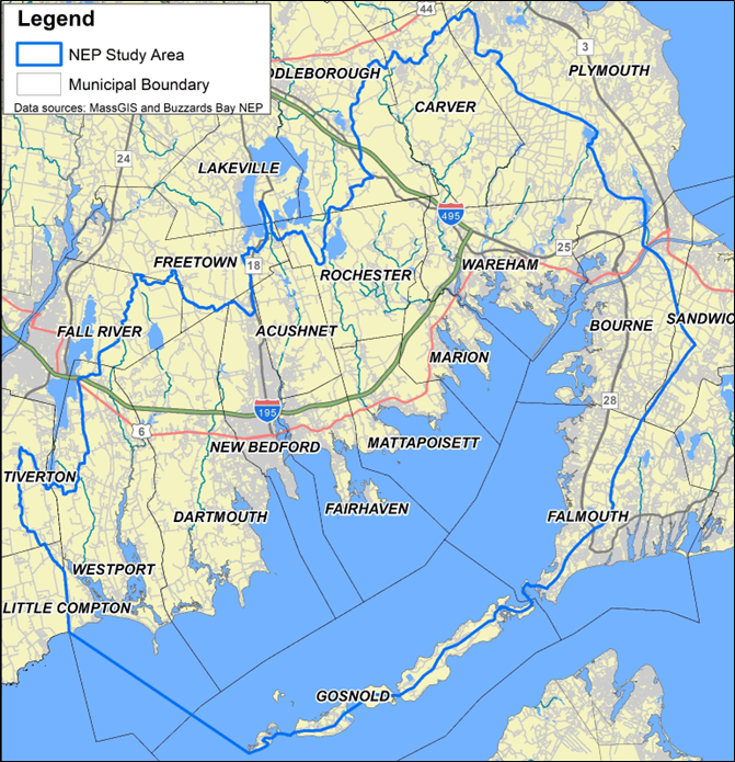
Buzzards Bay Study Area

Go to our Watershed Definition for more information. GIS users, download this zipped GIS data shapefile:
BBNEP_study_area_2024update.zip
Buzzards Bay is part of the Atlantic Intracoastal Waterway system and is connected to Cape Cod Bay by the Cape Cod Canal. The 480-foot-wide Cape Cod Canal (operated by the US Army Corps of Engineers) is the world’s widest sea-level canal and has a navigational depth of 32 feet at mean low water. As noted on the Army Corps Cape Cod Canal website, more than 20,000 vessels pass through the Canal annually. Many of these vessels are smaller recreational vessels, but in a busy 24-hour period, perhaps 30 to 60 larger transport vessels including tankers, barges, tugs, ferries, fishing vessels, container vessels, cruise ships, and other transport vessels pass through the canal. In 2002, the Army Corps noted that 1.9 to 2.0 billion gallons of petroleum products were shipped through the Cape Cod Canal annually (more info).
Buzzards Bay’s largest port New Bedford Harbor, is home to one of the largest fishing fleets on the East Coast, with approximately 270 vessels. For the past 5 years, the fleet ranked number one in the nation in terms of dollar value landed.
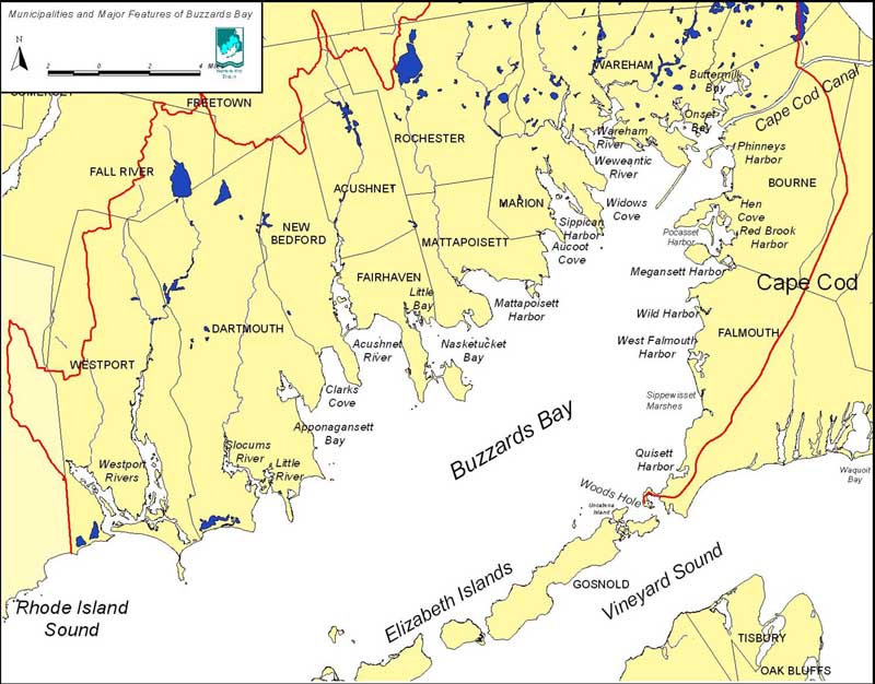
Eleven coastal communities share the bay (City of New Bedford and Towns of Westport, Dartmouth, Acushnet, Fairhaven, Mattapoisett, Marion, Wareham, Bourne, Falmouth, and Gosnold (Elizabeth Island Chain, town hall on Cuttyhunk Island), and 5 more are in the watershed, including nearly all of Rochester, and large portions of Plymouth, Carver, Middleborough, and Fall River. The Buzzards Bay watershed or drainage basin covers 434 square miles (1123 square kilometers) and includes all or sections of 17 municipalities. The watershed includes small portions of two additional communities in Massachusetts and portions of three communities in Rhode Island.
Based on the 2020 US Census, the population within the watershed boundaries (including the watershed portions of Falmouth and Bourne) is roughly 259,000 persons.
Along its western shore (west of the Cape Cod Canal) the drainage basin is formed by seven major river basins and a number of smaller ones. The largest river basins include the Agawam, Wankinco, Weweantic, Mattapoisett, Acushnet, Paskamanset, and Westport. The eastern shore of Buzzards Bay (Cape Cod Canal to Woods Hole) is drained mostly by groundwater. Several river systems smaller than those on the western shore also drain this portion of the basin. The prominent freshwater streams along the eastern shore are the Back, Pocasset, and Wild Harbor Rivers and Herring Brook.
In general, rivers within the drainage basin are slow-moving, meandering streams near their headwaters and for most of their freshwater length. Nearing the coast, the action of the tides rapidly widens the channels as the transition occurs from freshwater stream to tidal estuary. On average, Buzzards Bay rivers are considerably shorter (usually much less than 20 miles (34 kilometers) and have smaller drainage areas than other rivers within the state.
The Bay was formed during the last ice age approximately 15,000 years ago. Before that, Buzzards Bay was periodically submerged as glaciers advanced and retreated through the region, causing sea levels to rise and fall. The southeastern side of the Bay (Bourne, Falmouth, and the Elizabeth Islands) consists of glacial debris deposited by the glacier’s leading edge. Consequently, it has a relatively smooth shoreline composed mostly of sand and gravel particles. The northwestern side (Wareham to Westport), with its numerous elongated bays and inlets, was formed by the glacier’s retreat to the north. Many of these bays and inlets have since become sheltered from the ocean through the formation of barrier spits.
Tidal currents and wind are the dominant circulation forces in Buzzards Bay because the Elizabeth Islands protect the bay from large, long-period, open-ocean waves. Complete tidal mixing of Bay water with ocean water is estimated to occur every 10 days.
Water temperatures in the Bay range from a summer maximum of 71.6°F (22 °C) to 28 °F (-3 °C) in winter. During colder winters, the upper reaches of the Bay often freeze, whereas during the spring and summer, solar warming keeps surface waters warmer than the deeper waters. The water temperature gradually decreases in relation to depth until a point is reached at which the temperature drops abruptly. Below that point, known as the thermocline, the temperature resumes a gradual drop until the coldest depths are reached at the bottom. The thermocline can act as a barrier to vertical mixing within estuaries and bays. Water turbulence helps to break up the thermocline and diminish layering. The shallowness of the Bay, combined with surface wave mixing and turbulent tidal flow, prevents strong thermal stratification, so that the Bay is well mixed through most of the year.
Salinity has a small annual range and gradually increases offshore. There are few large streams bringing fresh water into the Bay, with the result that salinity offshore is essentially the same as that of other embayments, such as Block Island and Vineyard Sounds, that receive relatively little fresh water. In the semi-enclosed embayments along shore, salinity is more variable. Overall, the Bay is a tidally dominated, well-mixed estuarine system.

| Summary of town areas and year-round population (U.S. 2020 Census) within the Buzzards Bay watershed. | ||||||||
| Town | Municipal area w/ coastal waters sq. mi (1) | Buzzards Bay Coastal Waters (sq. miles) | Land sq. miles (2) | % in the watershed | sq miles in watershed | US Census 2020 population | Estimated 2020 population in watershed (3) | % of 2020 population in the watershed |
| Acushnet | 18.9 | 0.1 | 18.9 | 100.0% | 18.88 | 10,559 | 10,559 | 100% |
| Bourne | 57.3 | 16.2 | 41.1 | 83.2% | 34.17 | 20,452 | 15,346 | 75% |
| Carver | 39.7 | 0.0 | 39.7 | 84.3% | 33.5 | 11,645 | 9,364 | 80% |
| Dartmouth | 96.2 | 34.2 | 62.0 | 100.0% | 61.95 | 33,783 | 33,781 | 100% |
| Fairhaven | 40.9 | 28.5 | 12.4 | 100.0% | 12.41 | 15,924 | 15,924 | 100% |
| Fall River | 40 | 1.5 | 38.5 | 27.6% | 10.65 | 94,000 | 456 | 0% |
| Falmouth | 103.2 | 58.1 | 45.1 | 41.8% | 19.05 | 32,517 | 8,621 | 27% |
| Freetown | 36.4 | 0.9 | 35.5 | 13.7% | 4.88 | 9,206 | 1,689 | 18% |
| Gosnold | 135 | 121.6 | 13.4 | 52.3% | 7.04 | 70 | 34 | 49% |
| Lakeville | 36.1 | 0.0 | 36.1 | 0.6% | 0.21 | 11,523 | 53 | 0% |
| Little Compton, RI | NA | 0.0 | 22.6 | 1.20% | 0.28 | 3,616 | 289 | 8% |
| Marion | 28 | 13.9 | 14.1 | 100.00% | 14.12 | 5,347 | 5,347 | 100% |
| Mattapoisett | 42.3 | 24.8 | 17.5 | 100.00% | 17.49 | 6,508 | 6,508 | 100% |
| Middleborough | 72.1 | 0.0 | 72.1 | 23.50% | 16.99 | 24,245 | 2,038 | 8% |
| New Bedford | 33.4 | 13.1 | 20.3 | 96.10% | 19.48 | 101,079 | 99,132 | 98% |
| Plymouth | 176.7 | 74.7 | 102.0 | 43.60% | 44.73 | 61,217 | 7,771 | 13% |
| Rochester | 36.1 | 0.1 | 36.0 | 91.50% | 32.96 | 5,717 | 5,226 | 91% |
| Sandwich | 67.7 | 0.0 | 43.0 | 4.30% | 1.88 | 20,259 | 0 | 0% |
| Tiverton, RI | NA | 0.0 | 30.4 | 8.20% | 2.49 | 16,359 | 1,923 | 12% |
| Wareham | 46.4 | 9.3 | 37.1 | 100.00% | 37.14 | 23,303 | 23,303 | 100% |
| Westport | 89.8 | 37.7 | 52.1 | 85.30% | 44.46 | 16,339 | 12,311 | 75% |
| Watershed Totals | 1196.2 | 434.7 | 811.1 | 53.70% | 435.24 | 523,668 | 259,675 | 50% |
| Notes: (1) data source = bondyp1.shp from MassGIS, (2) Includes ponds and fresh surface waters, (3) U.S. 2020 Census tiger files census blocks were clipped to Buzzards Bay watershed and population and housing units were presumed proportional to clipped area in the watershed. Table excludes 4 acres and 3 persons in the Town of Kingston. | ||||||||