Jurisdictional Boundary Changes to Buzzards Bay and its Watershed
Related pages: Town by Town Info Nautical Charts
Download the 2024 update of our watershed boundary (zipped GIS shapefile): BBNEP_study_area_2024update.zip. (Includes some minor changes on Cape Cod to ensure consistency with recent watershed boundaries adopted by the Cape Cod Commission and the Massachusetts Estuary Project.)
General Note the Buzzards Bay Watershed and Sub-basins
The Buzzards Bay basin delineation for the watershed we use represents the jurisdictional boundary of the Buzzards Bay National Estuary Program as defined in the Buzzards Bay Comprehensive Conservation and Management Plan adopted by the Commonwealth of Massachusetts and the US EPA in 1992. It differs from the Buzzards Bay jurisdictional boundary adopted by some other programs within the Commonwealth, which omit Cape Cod in the Buzzards Bay “watershed” for various political or regulatory reasons. In addition, the major basin in the Wareham-Plymouth-Bourne adopted by the Buzzards Bay NEP was based on groundwater delineations and recommendations from USGS and differs from land surface topography delineations adopted by some other programs. Finally, the subbasins on Cape Cod have been adopted from the Cape Cod Commission’s best and most recent delineations and differ somewhat from those adopted by the Buzzards Bay NEP in 1990.
Purpose of this page
The development of an accepted delineation of the Buzzards Bay watershed is important because it not only defines the potential pollution contribution area that could affect Buzzards Bay, but it also identifies the jurisdictional interests of the Buzzards Bay National Estuary Program as it relates to our grants and technical assistance program. This boundary information is also used by the Buzzards Bay NEP and its partners to track and characterize land use within the watershed, and to monitor efforts to protect and restore habitat and water quality. This page is presented for informational and discussion purposes to help reformulate the Buzzards Bay NEP jurisdictional limits and interests to be contained in the updated Buzzards Bay Comprehensive Conservation and Management Plan. Please email Email us with your comments.]
Documentation and Rational for Buzzards Bay and Bay Watershed Boundary Changes
by Dr. Joe Costa
Government bodies may establish jurisdictional boundaries of non-politically defined geographic areas like bodies of coastal waters and watersheds based on definitions contained in laws, regulations, policies, or based on the definition of commonly understood terms. It is possible for different levels of government, or different agencies to adopt different jurisdictional boundaries for these areas based on special needs or management interests. Scientists, when conducting studies or assessments of the environment, may choose to use these boundaries, or use other boundaries based on new scientific information, or to enable comparisons to previous studies.
When it comes to coastal bodies of water, there are sometimes discrepancies between the understanding of these boundaries among residents, and what is documented on various maps and charts. Contributing to the problem is that water place names have changed or been removed over time on government charts. Water bodies are not delimited by boundary lines, like state and municipal borders, and inlets and bays without clearly defined headlands, or multiple widening headlands are often subject to multiple interpretations of embayment area and limits, and consequently differing interpretations of how to bring inland watershed boundaries to the outer coast.
Like water bodies, the delineation of watersheds has been subjected to different jurisdictional definitions among agencies but is also influenced strongly by new scientific understandings of hydrological pathways. The definition of watershed boundaries is based on the concept of water catchments and hydrological characteristics of land surrounding a water body, and the assumed or documented movement of both surface and groundwater. In Massachusetts, most of the early watershed delineations (established first in the water quality standards documents of the 1970s), used land surface topography to define the catchments area. This was largely justified because land elevations for large parts of Massachusetts, closely follows granite bedrock in the region. This situation establishes what is known as bedrock valley watersheds in New England.
Beginning in the 1990s, it became more widely recognized among managers that that large portions of Southeastern Massachusetts beginning around Middleborough and extending east through Cape Cod were composed of glacial materials and surface sandy soils, and that the true watersheds of these areas were based nearly exclusively on groundwater elevations, which were independent of land surface topography.
These two confounding issues explain why the boundary of the Buzzards Bay Watershed changed so much during the 1980s and 1990s. Still, despite the improved scientific understanding of watersheds in Massachusetts, the jurisdictional boundaries of watershed boundaries have not changed among some agencies. While Section 320 of the Clean Water Act (National Estuary Program) mandated that the jurisdictional interests of the Buzzards Bay NEP encompass the entire contributing land area around Buzzards Bay, which includes Cape Cod, for pragmatic scientific and political reasons, in the 1990s the Massachusetts Department of Environmental Protection eliminated Cape Cod from the Buzzards Bay watershed, which now encompasses only the western shore of Buzzards Bay. All of Cape Cod is included in a Cape Cod watershed. For a regulatory agency this made some sense because all of Cape Cod (except the portion of Bourne on the West side of the Cape Cod Canal) is part of the Cape Cod aquifer, and also subject to regulatory control of the Cape Cod Commission. It thus represented a logical management area unit. In the panel on the right, the various jurisdictional boundary definitions of Buzzards Bay and the Buzzards Bay watershed are shown, with further detailed explanations in the sections below.
Revisions to the Buzzards Bay Watershed Since Program Inception
The first watershed boundary used by the Buzzards Bay NEP was a watershed land surface water flow boundary first developed and used by Massachusetts Department of Environmental Protection Division of Water Pollution Control in the 1970s and 1980s pursuant to 314 CMR 4.00 (surface water quality standards). This boundary included Bourne and Falmouth on Cape Cod and followed the top of the Cape Cod glacial moraine (Figure 1, right). By 1989, the Buzzards Bay NEP rejected this particular Cape Cod boundary based on groundwater flow information. Also, in the 1990s, DEP ceded the Cape Cod portion of the Buzzards Bay watershed in an update of its surface water quality standards maps, as laid out in later updates of 314 CMR 4.00, to form a single unified “Cape Cod watershed.”
The Buzzards Bay Cape Cod Boundary
In 1989, the Buzzards Bay NEP, in consultation with USGS and the Cape Cod Commission, defined and adopted a watershed boundary on Cape Cod based on groundwater isopleths maps developed by the Cape Cod Commission based on groundwater elevations in well data they had collected and assembled. By this time, it was widely recognized that the top of the groundwater lenses for upper Cape Cod were near the central portion of the Bourne-Sandwich boundary, and that groundwater west of this area, and including some of the recently discovered contaminant plumes on the Massachusetts Military Reservation, were flowing to Buzzards Bay. This Cape Cod boundary was included in the Buzzards Bay CCMP approved by the Governor and EPA Administrator in 1991-92 (Figure 2, right).
Using this information, the Buzzards Bay NEP also developed subwatershed boundaries for Cape Cod, which were also included in the CCMP. In the mid-1990s, the Cape Cod Commission adopted new nitrogen management regulations, and at the same time updated their subwatershed boundaries for all of Cape Cod, including those originally defined by the Buzzards Bay NEP (see below). These new subbasins were used by the Buzzards Bay NEP as the basis of the updated nitrogen loading estimates to the Buzzards Bay watershed in 1999. While the Cape Cod Commission did not define a “Buzzards Bay watershed” per se, the new subbasins implied that the Buzzards Bay watershed should be moved slightly in the vicinity of the top of the aquifer, and in the vicinity of Long Pond in Falmouth. The Buzzards Bay NEP did not address these shifts of the watershed boundary, but they are now under consideration for the updated CCMP. Currently the BBNEP is using new watershed delineations adopted by the Massachusetts Estuaries Project in the 2004 between 2004 and 2008 including boundaries used for the studies of Phinneys Harbor, Eel Pond and Back River, Quissett Harbor, West Falmouth Harbor, Falmouth South Coastal Ponds.
The Northern Groundwater Boundary
In 1989 and 1990, the Buzzards Bay NEP worked with USGS to refine the Buzzards Bay northern Boundary based on groundwater data developed by the USGS. USGS developed maps that were digitized by the Buzzards Bay NEP (original transfer lines on quad sheets at the BBNEP office). This groundwater-based watershed boundary was matched to the point on the canal near the existing DEP defined Buzzards Bay basin (just south of Herring River) and continued to a portion of Middleborough where it could be reasonably assumed to match with a real groundwater-based aquifer boundary. An interesting artifact of this line was that it was presumed that Herring Pond and some other ponds in Plymouth were at groundwater divides and were at the highest point of local groundwater elevations. Consequently, many of these ponds are bisected, and the Herring River itself remained in the South Coastal watershed.
Like the Cape Cod groundwater boundary, this northern boundary was included in the Buzzards Bay CCMP approved by the Governor and EPA Administrator in 1991-92. Most agencies did not adopt this boundary, but DEP appeared to adopt this boundary change in their 2000 update to their surface water quality standards (Figure 5). MCZM adopted this boundary in some coastal watershed publications. Despite the fact that USGS helped develop this watershed boundary, and used a similar boundary in models of stream flow for some Buzzards Bay subwatersheds, and is also supported in part by well Zone 2 studies, neither USGS nor most state agencies adopted this boundary (e.g., the USGS Massachusetts Water Resources of Massachusetts publication just focuses on surfaces water drainage systems).
However, in 2000, DEP amended its surface water quality standards 314 CMR 4.00 to incorporate a more realistic groundwater-based watershed boundary for Buzzards Bay, as well as an extension in the area of Lakeville, Rochester, and Middleborough (see below). Still, many EEA and DEP watershed maps still show the land surface divide as the northern boundary for Buzzards Bay, and that coverage is available at the Mass_GIS website.
Through the DEP Massachusetts Estuaries Project, and through companion efforts, DEP and USGS have undertaken a study and reassessment of aquifers in Southeastern Massachusetts, which was published in 2009. The USGS report summarizing their findings can be found in USGS Circular 1338. The USGS GIS coverage supporting this study is available at: this link. The USGS data set was smoothed to 100 m intervals and was intersected with earlier Buzzards Bay watershed coverages.
Through the DEP Massachusetts Estuaries Project, DEP and USGS have undertaken a Plymouth-Carver Aquifer Study, which was published in 2009, which also defined Cape Cod embayment recharge areas.
The Quittacas Ponds Bulge
In June 2000, MassGIS created a major watersheds boundary based on USGS Water Resources Division and the MA Water Resources Commission information. This layer extended watersheds beyond the state boundary to include the full extent of either the full river basin watershed or a full USGS sub-basin. According to MassGIS, “the WATRSHDS layer was originally based on the MAJ_BAS layer and then modified to fit the needs of the MassGIS Watershed Analyst project. In some cases, the out-of-state sub-basins were clipped to include data that affect stream flow into or out of Massachusetts.”
What is most significant about this layer besides including Rhode Island in the Buzzards Bay watershed is that it changes the Buzzards Bay watershed to incorporate the area around Little and Great Quittacas Pond in the Lakeville-Rochester-Middleborough area. This change was included in the state’s surface water quality standards regulations 314 CMR 4.00 in 2000. It was also incorporated in MassGIS’ November 2005 Megabasins data layer. The Quittacas watershed is not included in the USGS HUC watershed boundaries.
While it has long been recognized that the Quittacas Pond System was near a watershed divide, and sometimes the pond system was recorded as flowing south into the Acushnet River toward Buzzards Bay, it does not appear this map has any regulatory or policy implications for the Buzzards Bay watershed under the Inter-basin Transfer Act, because the maps adopted under this law are defined by maps in a different set of regulations: 314 CMR 4.00 and supporting maps. If such a change were adopted for Buzzards Bay under 313 CMR 4.00, it would have major regulatory implications because New Bedford water withdrawals would no longer be subject to the Massachusetts Interbasin Transfer Act.
Cape Cod Subbasin Shifts
In the early 1990s, the Buzzards Bay NEP worked with USGS and the Cape Cod Commission to define subbasin boundaries for Buzzards Bay embayments on Cape Cod. In the late 1990s, the Cape Cod Commission revised these subbasins based on new well data information. The Buzzards Bay NEP adopted these new delineations in its revised nitrogen loading estimates released in 1999. These new basins (figure 6) were incorporated in maps contained in the Cape Cod Regional Policy Plan (20 MB pdf) enacted in 2002.
In December 2005, MassGIS released a new state-wide Subbasin Coverage that included subbasins for Cape Cod. However, the subbasins incorporated both the original Buzzards Bay embayment boundaries developed in 1990, and some other information, but not the Cape Cod Commission boundaries adopted in 1998 (figure 7). The Buzzards Bay NEP is working with MassGIS to update this coverage.
The Competing Westport-RI Boundaries
The watershed of the West Branch of the Westport River extends into Rhode Island. The original Buzzards Bay NEP watershed boundary was based on the USGS Aquifer (#9) data layer, which differed from the MassGIS Megabasin and Watersheds data layers, which in turn differ from the USGS HUC watershed data layers. The three competing boundaries are shown in figure 8.
Separate from the issues surrounding the West Branch of the Westport River boundary is the fact that there has never been effort to separate the Richmond Pond (in MA) watershed from the Quicksand Pond (in RI) watershed. If Richmond Pond is considered part of the Buzzards Bay watershed, then a real hydrologic boundary for Buzzards Bay will not follow the state line as now adopted. However, the adjustments to this line would be so minor (losing some MA land and gaining some RI land), that it is not practical to change this boundary.
The Bisecting of the Elizabeth Islands
To be consistent with other parts of the watershed, in the late 1990s, the Buzzards Bay NEP bisected the Elizabeth Island chain down the middle of each island (figure 2) based on assumed groundwater pathways, rather than land surface topography. Undoubtedly this is a simplistic approach, but because the Island chain is subject to few human activities, efforts to expend resources to improve upon this boundary line are not justified.
Contradictions with Zone 2 well recharge areas.
Municipalities generally hire contractors to define well recharge zones for public supply wells. These so-called zone 2 well recharge areas are based on evaluation of soil borings, water table elevations, projected pumping rates, and other information. For each well, this data was collected at differing times and years, with varying levels of data, and sometimes during less than typical rainfall and recharge conditions. Moreover, as more public wells have been constructed, and water withdrawals have increased, the actual flow lines and pathways of groundwater have likely changed over time.
Given this set of circumstances, it is therefore not surprising that some zone 2 recharge areas conflict with others, or straddle watershed boundaries (figures 10, and 11). Ideally, any realistic watershed boundary, especially one based on groundwater elevations, should agree to the maximum extent practical with these zone 2 data sets.
Extension of Buzzards Bay NEP Jurisdictional Interests to all of Massachusetts waters
The boundary definition of Buzzards Bay has been the subject of discussion and correspondence by the Buzzards Bay NEP. (Read this letter to the WRWA on the definition of the boundary of Buzzards Bay and its watershed.). Strictly speaking, the entrance of Buzzards Bay on nautical charts (or at least the “Inland Waters” boundary of the COLREGs) was a line drawn on the map between the tip of Gooseberry Point in Westport, and the southeast corner of Cuttyhunk Island (Figure 12; this is also the definition adopted by the Massachusetts Legislature in the Acts of 1898). On nautical charts, somewhat beyond this line, the waters are labeled Rhode Island Sound. For very practical reasons, both DEP and the Buzzards Bay NEP extended the definition of Buzzards Bay to the Rhode Island border. However, this boundary had one shortcoming–it omitted some state and town waters within Gosnold and Westport. These state waters were actually included in the Buzzards Bay Action Committees boat waste no-discharge application, which was approved by the US EPA in 1999. However, these town boundary lines shown on quad maps actually do not coincide with the presumed extent of state waters as described below.
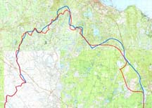
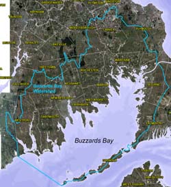
In 2009, as part of the update of the new Buzzards Bay CCMP, the Buzzards Bay NEP adopted a slightly revised “Study Area” definition (jurisdictional interests of the program) shown in the figure to the right. Specifically, the watershed northern and Cape Cod boundaries were made consistent with new groundwater divide information from USGS defining the groundwater contribution areas based on the study described above. (The USGS report summarizing their findings can be found in USGS Circular 1338. The supporting GIS coverage is available at: water.usgs.gov/GIS/metadata/usgswrd/XML/ds451_gwcontrib_areas.xml).
The revised NEP study area totals 684 square miles (=438,142 acres or 1,773 square kilometers). This study area consists of 434 square miles of land (=277,606 acres or 1,123 square kilometers; includes land in both Massachusetts and Rhode Island [6.8 sq miles], freshwater pond area not broken out) and 250 square miles of water in Massachusetts (160,536 acres or 650 sq. kilometers; includes a small portion of areas on nautical charts sometimes labeled Rhode Island Sound in Massachusetts waters). This coverage builds upon earlier coverages.
The Buzzards Bay NEP is also considering revising its study area based upon the Massachusetts Ocean Plan and some other recently adopted state and federal definitions of Buzzards Bay (Figure 12). In 2004, the Massachusetts Legislature defined Buzzards Bay as “the waterway bounded and described as follows: from Sakonnet Point southward to the north end of the Buzzards Bay traffic separation zone, to the southwestern tip of Cuttyhunk Island thence through Buzzards Bay to the eastern entrance of the Cape Cod canal at the United States Coast Guard “CC” Buoy in Cape Cod Bay, including Woods Hole Passage and Quicks Hole. In 2007, for pilotage regulations, the USCG adopted a similar definition, but only extending as far southeast as the Buzzards Bay entrance light and tower. These two boundaries are shown on figure 12.
Buzzards Bay Subbasins
In 2009, the Buzzards Bay NEP updated it subbasin coverage to make it consistent with our major basin boundary and the latest GIS data and subwatershed delineations (including groundwater boundaries) from the MEP, DEP, and USGS. MEP defined boundaries were given precedence where inconsistencies existed between data sets. More information about these coverages can be found on our Nitrogen Management origins page
In November 2010, the Cape Cod Commission presented a slideshow (http://www.capecodcommission.org/watertour/Watersheds_PowerPoint_111010.pdf) that showed the subwatersheds on Cape Cod which they and the Mass Estuaries Project have adopted. The GIS data for these watersheds is contained in the following shapefile:
ccc_public_watersheds_nov2010.zip (a more recent version may be available)
The BBNEP has adopted these subwatershed delineations, and they were incorporated in the 2014 major basin boundary included above.
April 2010 Buzzards Bay watershed sub-basin boundaries. (zipped GIS shape file; used by some of our partners for past studies).
2017 Buzzards Bay watershed sub-basin boundaries. (zipped GIS shape file; updated in 2016 to better coincide with sub basin boundaries on Cape Cod used in recent MEP TMDL studies, with additional partitioning of certain embayments including Megansett).
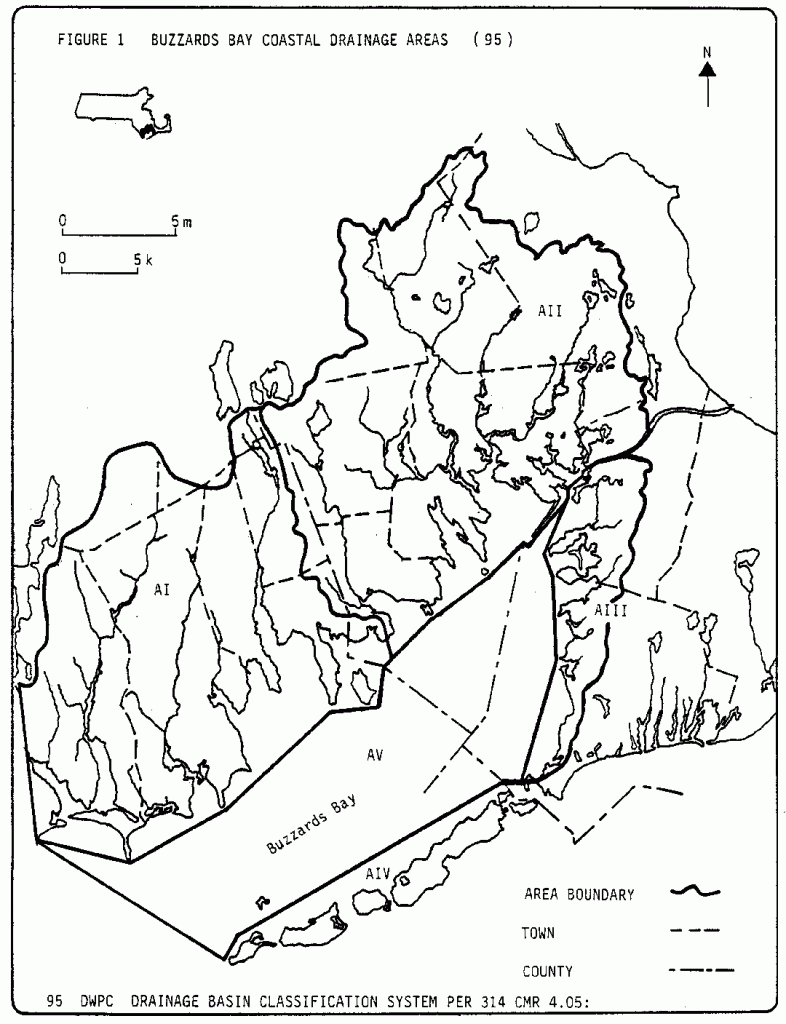
Fig. 1. The original Buzzards Bay NEP watershed adopted in 1985 was the one in use by DEP between the 1970s and the mid 1990s. This watershed included Cape Cod and followed the top of the Cape Cod glacial moraine in Bourne and Falmouth. This boundary was used by the NEP until 1989. Map from DEP’s 1986 Water Quality Report for Buzzards Bay (3.3 MB pdf). Click on the map for an enlarged version in a new window.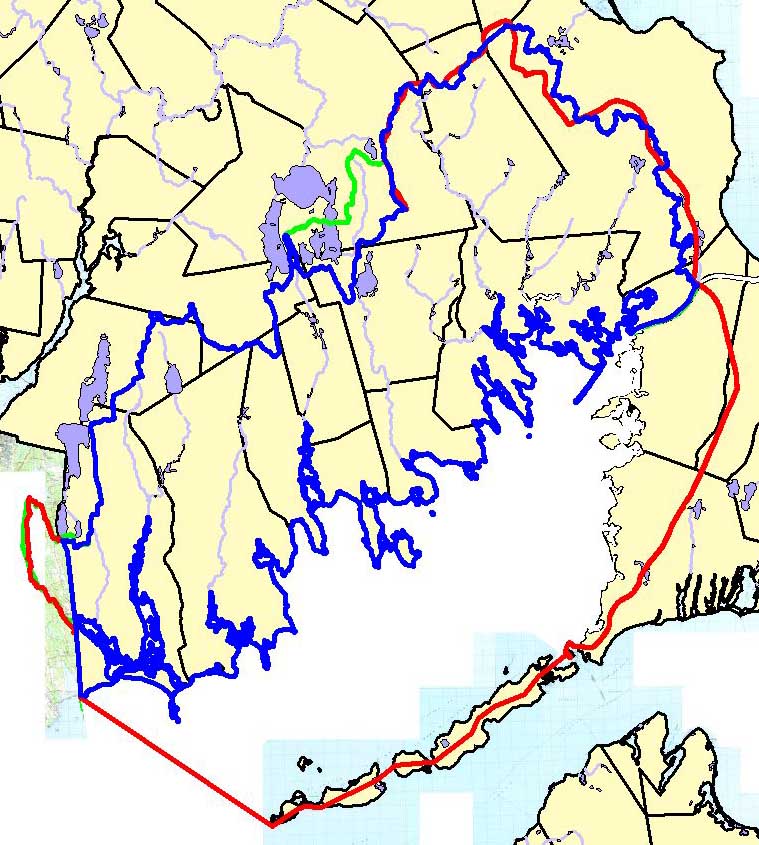
Fig. 2. A Buzzards Bay watershed boundary still used by many state agencies (blue line) compared to the Buzzards Bay NEP boundary (red line adopted in the 1992 CCMP and approved by the Commonwealth and US EPA), which includes Cape Cod, and a portion of Rhode Island. Click on the map for an enlarged version in a new window.
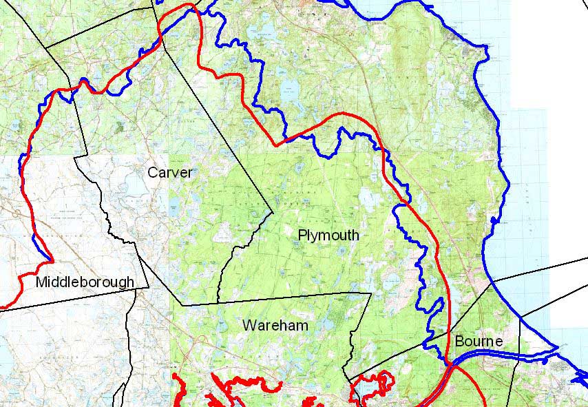
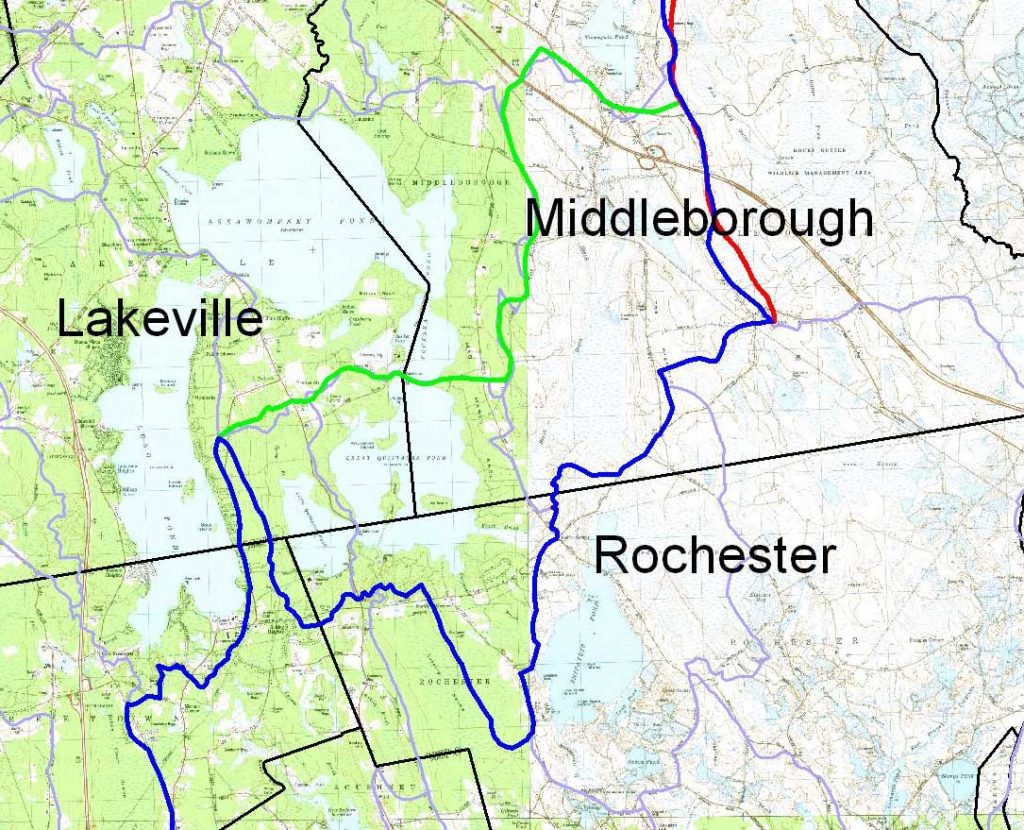
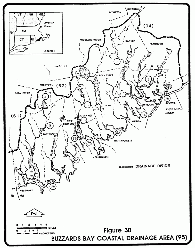
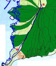
Fig. 6. Adjustments needed in Cape Cod watershed. Click on the map for an enlarged version in a new window.
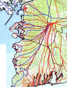
Fig. 7. Inconsistencies between MassGIS subbasins December 2005 data layer (blue lines) and CCC 1999 subbasins (red lines).
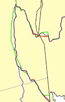
Fig. 8. Inconsistencies at the Rhode Island border between the existing Buzzards Bay watershed (red line USGS Aquifer 9) versus MassGIS-DEP subbasin and USGS HUC data layer (blue line) versus MassGIS Megawatershed and Watershed data layers (green line).
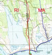
Fig. 9. A possible surface recharge area watershed boundary for Richmond Pond, separate from the Quicksand Pond watershed. This change is so trivial, the Buzzards Bay NEP proposes to maintain the existing state line boundary.
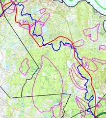
Fig. 10. Inconsistencies between various well zone 2 boundaries (magenta) and the BBNEP and MassGIS major basin boundary in the north portion of the Buzzards Bay watershed.
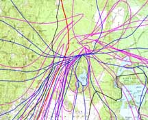
Fig. 11. Inconsistencies between various well zone 2 boundaries (magenta) and the Cape Cod Commission subbasin boundaries (blue).
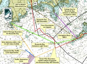
Fig.12. The various jurisdictional boundaries of the entrance to Buzzards Bay.
Click to enlarge
Fig.13. 2009 revisions (red line) to the Buzzards Bay Study Area in the Plymouth Aquifer Area based on the 2009 USGS study.
Click to enlarge
Fig.14. 2009 revisions to the Buzzards Bay Study Area
In 2021 and 2024 we further refined the Cape Cod boundary to better coincide with the Cape Cod’s latest definitions of Buzzards Bay embayment subwatersheds, and further refined the Plymouth Wareham boundary to better coincide with USGS models for the buttermilk Bay and northwestern Wareham areas, Download the 2024 version of our watershed Boundary (zipped shape file): BBNEP_study_area_2024update.zip. This version includes some minor boundary changes principally on Cape Cod, to ensure consistency with watershed boundaries adopted by the Massachusetts Estuaries Project and the Cape Cod Commission.