by Joe Costa
related pages:
- Geo-referencing historical aerial photographs (incl. archive sources)
- Historical aerial surveys in SE Massachusetts
Interpretation of Aerial Photographs
Since the 1980s, scientists have routinely used vertical aerial photographs to map current and historical distributions of eelgrass. These photographs may have been taken for documenting land-based features, but some older surveys, and some newer ones were taken to maximize visibility of subtidal features. In Buzzards Bay, aerial photographs were used to map eelgrass by Costa in the 1980s, and by DEP initially in 1995 and 2001. Since those initial surveys, DEP and the Buzzards Bay NEP have interpreted eelgrass distribution in Buzzards Bay from aerial surveys taken in other years. Fig. 1 shows of how different eelgrass surveys might compare for a particular site.
Today, the mapping of seagrass beds is undertaken with heads of digitizing of features on georeferenced aerial photographs, using GIS software. The delineation of eelgrass habitat using aerial photographs requires experience and an understanding of how the texture, color, and general appearance of different subtidal habitat features appear in color, infra red, and black and white imagery of different scale, quality, tidal elevations, weather conditions, and times of year. The ability to map eelgrass habitat also depends on the availability of aerial photographs and their quality, available field information, and familiarity of the analyst with the different habitat types typical for an area, whether within an embayment, or on the open coast.
Not all dark features on aerial imagery are eelgrass beds. Dark colored features may be algae-covered cobble or boulder fields, drift algae, salt marsh peat, silty sediments (generally only in protected embayments), dredged channels, mollusk reefs, or other potential features. Interpretation of these features may require field verification, unless inferences can be made using other data sources, preferably in a GIS software environment. The most important of these ancillary data sets are bathymetric charts or bathymetric digital elevation models in a GIS environment, because eelgrass will only be found within a certain depth range within a particular area. Generally eelgrass grows to greater depth in clear waters of the outer coast, and to lesser depths in embayments. Past eelgrass surveys should be reviewed to recognize the maximum depth eelgrass was previously mapped. Deeper eelgrass beds may have been overlooked in past surveys because of poor water transparency, but features occurring at a depth well beyond previous depth maxima reported for eelgrass are generally other types of habitat.
Field verification is important for eelgrass mapping, particularly for certain types of habitat and locations. In the initial Buzzards Bay surveys, both Costa and DEP used field verification with boats, and Costa used diving (skin or SCUBA) as well. Because it is impossible to verify every eelgrass bed mapped, most field surveys might validate only 5 to 10% of the beds, and often focus on features that may be difficult to interpret. If previous surveys confirmed the presence of eelgrass with field observations, this information is of value when interpreting historical or more recent photographs of lesser quality. As described below, benthic video and photograph surveys provide excellent supporting documentation, and aid the analyst in understanding different habitat types that might be mistaken for eelgrass.
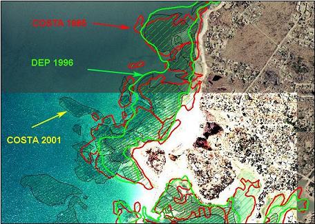
Fig. 1. Comparison of eelgrass distribution near the mouth of West Falmouth Harbor based on three different dates of aerial photographs (1981, 1995, 2001).
With respect to interpreting aerial photographs, the time of year photographs are taken is one of the most important considerations. Eelgrass is a perennial, but where it does not over winter or does not survive late summer heat, it is a functional annual. In general, eelgrass growing in deeper waters on the outer coast can be seen on aerial photographs year-round. In winter and spring photographs, eelgrass beds appear less dense, and estimates of percent habitat cover may be less than photographs taken later in the growing season. In many embayments, particularly in shallows, eelgrass beds that are present in late summer may be absent or have very reduced density between December and early May. Occasionally, some lower subtidal flats do not have eelgrass cover (grown from seed) until late June. Thus, photographs covering shallow embayments, particularly between January and June, must be interpreted with caution. Most aerial surveys of this region have been taken between March and December, but photographs taken during September and October that coincide with good water transparency are often the best surveys for interpreting aerial photographs. The series of photos in Fig. 2 illustrate these points.
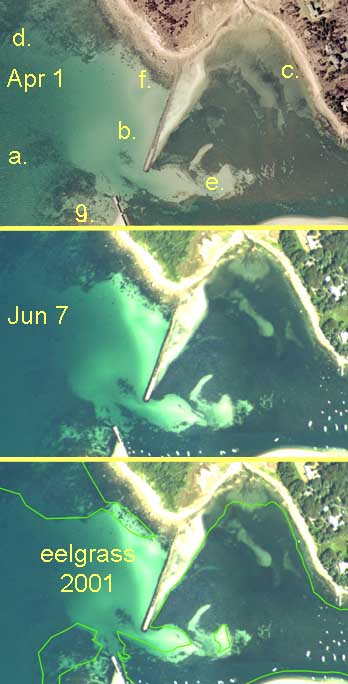
The top photograph was taken on April 1, 2001 and the middle one on June 7, 2001. The latter was the basis of the DEP’s eelgrass 2001 eelgrass survey. This photograph was photo enhanced to improve brightness and contrast, which may not have been done for the final eelgrass bed boundary interpretation (bottom photo).
Fig. 2 top was taken on April 1, 2001 and the middle one on June 7, 2001. The latter was the basis of the DEP’s eelgrass 2001 eelgrass survey. This photograph was photo enhanced to improve brightness and contrast, which may not have been done for the final eelgrass bed boundary interpretation (bottom photo, green boundary lines). As shown in the top photograph, many eelgrass beds were present in April, although they did not have as dense an appearance as the June photograph when the leaf biomass (especially density and length) was much greater. The expansion of some eelgrass beds by June is apparent by comparing the two photographs (e.g. at “b”). Notice that the shallow area “c” in the top photograph was unvegetated in April, but eelgrass beds had grown in by June. Also note that the deep bed at “a” in the top photo was not included in the final DEP map (bottom), because this area was quite dark in the original photograph and difficult to discern, although deep area “d” was discerned. Area “b” was an eelgrass bed (perhaps also with rocks) that was not included in the DEP survey because it may have been too small of a bed for the mapping criteria. Area “f” was quite sparsely vegetated in both photographs but still included in the survey coverage. The increased darkening of the area shoreward of this bed in the June photograph suggests that there was probably considerable eelgrass growth within the boulder field closer to shore. Area “g” certainly had considerable eelgrass, but the photo interpreter may have assumed that this area was predominantly algal covered boulders. Area “e” had the largest bare patch included in the DEP survey, but other smaller bare areas or sandbars were not added as “holes.” These decisions were compromises for simplicity.
The photographs in Fig. 2 also illustrate a second important point about interpreting aerial photographs: it is beneficial to have several different dates of photographs to interpret for an area, even if the photographs were not taken under ideal conditions. The above photograph pairs are ideal because they were taken only months apart. If an area is sand, but later vegetated, it can only be eelgrass or drift algae. If a dynamic offshore area is identical from year in photographs, it is likely an algae-covered rock field. Algal covered rock fields, drift algae, and eelgrass beds can be further distinguished by other clues of texture and color. For example in fall color aerial photographs, eelgrass beds often have a distinct brownish hue in color photographs from the growth of algal epiphytes on the leaves, whereas deeper drift algal accumulations have a more uniform darker color.
One of the biggest challenges to characterizing eelgrass bed distribution and creating a GIS polygon coverage is the fact that eelgrass “beds” are seldom continuous monocultures, and either bare patches or other benthic habitat may be interspersed. Depending upon the scale of any aerial survey, different levels of patchiness are apparent. An aerial survey taken from 10,000 feet may show bare patches within an eelgrass bed, and other areas may seem continuous. These continuous areas may in fact have smaller bare patches evident in low altitude aerial surveys. Even in lower altitude photographs, when diving in what appears to be a continuous bed, small bare areas from less than a meter to several meters may be evident. Sometimes eelgrass beds do not have distinct or discernible boundaries, and show a gradual tapering off. In attempting to delineate eelgrass bed boundaries, a subjective decision must often be made to decide where the boundary is, and there are multiple ways in which a polygon coverage may be created depending upon the level of detail desired. In the Costa 1988 study, most of the interpretation was based on what is evident at a roughly 1:25,000 projection.
Besides patchiness between eelgrass beds and bare areas, eelgrass beds may exist within sandy patches in rock and cobble areas in offshore high wave energy areas, or mixed with drift and attached algae in sheltered embayments. Both these types of mixed habitat areas pose special problems in characterization because eelgrass may be present, but only in a small percentage of bottom cover. In the Costa 1980s surveys, such mixed areas were delineated as an eelgrass “bed”, even if eelgrass cover may have been characterized as 20% to 50%, because each polygon was assigned an attribute based on percent cover. In the DEP survey, such areas may have been characterized principally as algae, and not included in the 1996 maps, even though some patches of eelgrass may be present.
On outer coasts, where eelgrass typically grows on sand, eelgrass appears as a dark region on a light background of sand. In protected embayments with muddy bottoms, contrast between eelgrass and its background is reduced, but eelgrass can still be discerned as a dark patch on a slightly lighter bottom. On the outer coast, only algae covered rock and cobble can be mistaken for eelgrass, but the different “texture” of these beds on photographs makes their identification possible. In protected embayments, eelgrass is more difficult to identify because it typically grows on mud bottoms that offers reduced contrast between the beds especially on black and white photographs. Furthermore, there is often a large accumulation of attached or drift algae in these areas which may be mistaken for eelgrass. When eelgrass grows on a bottom covered with drift algae, however, the beds appear as a slightly lighter colored on a dark background.
Rocky Intertidal
Rocky intertidal areas might be difficult to interpret in a particular aerial survey if the survey was flown during high tide with poor water transparency. If another aerial survey is available that coincides with low tide, these areas can be more readily discerned. In addition, color infra-red aerial imagery, which might have been previously flown during early spring for vegetation analysis (e.g., certain surveys available from the USDA NAIP website), shows features with a strong chlorophyll signature as bright red. Golf courses and lawns appear bright red, but so do rockweed-covered rocks (Ascophyllum and Fucus). If the aerial survey was undertaken during low tide, algae covered boulder fields easy to interpret as shown below in the April 1990 image from the outer coast of Westport.
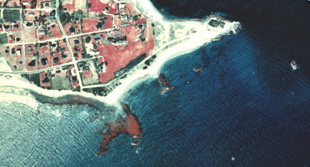
Color infra-red aerial photograph of the outer Westport coast showing rockweed covered boulders offshore as bright red.
Benthic Video and Photo Surveys
There have been a number of recent benthic video and photographic surveys in Buzzards Bay that can affirm interpretations of imagery, and when studied, provide great insight into other features and habitat in deeper waters visible in aerial surveys taken during conditions of good water transparency. For example, Fig. 3 shows an area near the entrance of the Cape Cod Canal, near Mashnee Island. The benthic images affirm previously mapped eelgrass beds, but also identify some smaller unmapped eelgrass habitat areas (the dark, fine striations in the center of the photographs). These are eelgrass beds, and their appearance is caused by vegetative growth of eelgrass shoots in a linear pattern in these high current dynamic sandy environments, where vegetative growth and bed expansion occurs parallel to the ebb and flood currents. Benthic video surveys conducted by Hubbard and Massachusetts Maritime Academy Students affirm this interpretation (inset in Fig. 3).
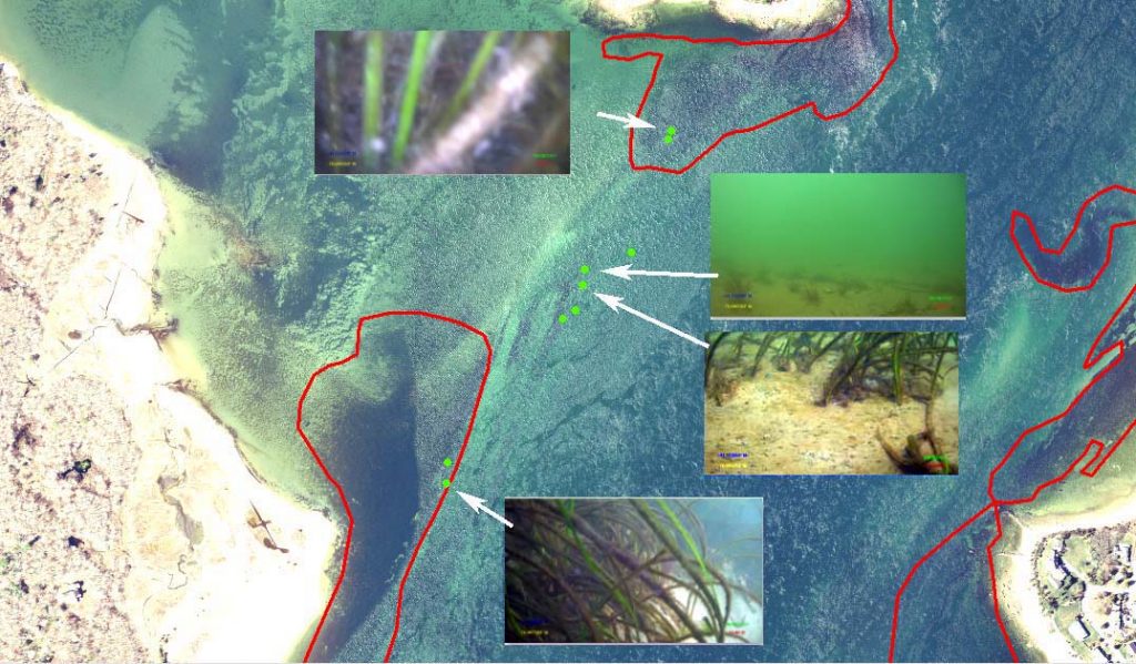
Fig. 3. Aerial photograph of eelgrass beds near the entrance of the canal (major boundaries defined in red) with benthic images shown for selected sites (green dots). Benthic imagery from Hubbard (2017). Final Report MMA/CAF Benthic Studies in Buzzards Bay, MA. See explanation in text for eelgrass beds with thin striated appearance in the center of the image. Image contrast and brightness were adjusted. Click the image to enlarge.
In upper Buzzards Bay, other dark features are evident in aerial photographs in areas below the 12 ft bathymetric contour. Some of these dark features are reefs of the slipper shell, Crepidula fornicata, which are common and extensive in some parts of Buzzards Bay (Ackerman et al., 2014; Hubbard 2016, 2017; see Fig. 4).
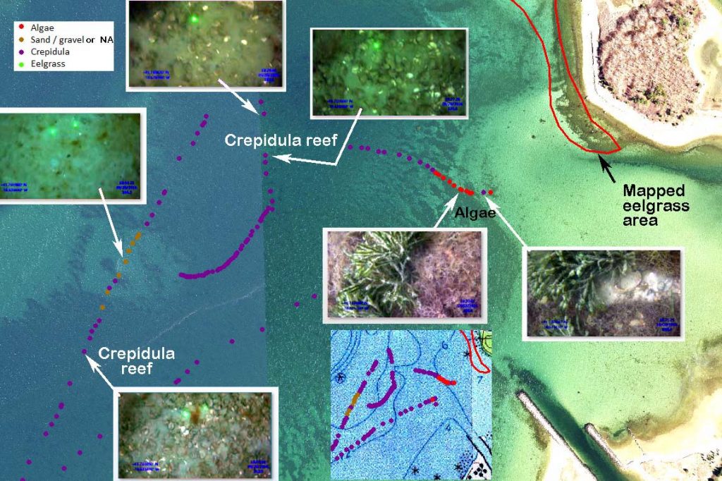
Fig. 4. Mollusk reefs, principally the sessile snail Crepidula fornicata, in deeper waters near the Pocasset River, in Bourne. Note in this site, eelgrass is in shallow waters, attached algae on rock and cobble begins at about the 6 foot depth (see bathymetry inset), and in deeper water, below 6 feet MLLW (or deeper), are extensive areas dominated by Crepidula. Click the image to enlarge. Photograph inserts taken from Hubbard 2017 study.
Large subtidal boulder fields can also appear as dark features in aerial photographs of many areas of Buzzards Bay. These are glacial deposits, and are particularly prominent along the glacial moraines that stretch through Bourne, Falmouth, and the Elizabeth Islands. In the Elizabeth Islands, near shore, generally in less than 15 feet of water, eelgrass can be found in abundance in sandy patches within these boulder fields. However, in deeper waters below the photic zone of eelgrass, but within the photic zone for macroalgae (to 15 feet at the north end of the bay, to 30 feet at the south end), red and brown algae can be the dominant cover on these rocks, making them distinct from surrounding sandy areas in aerial photographs where water transparency is good. An example features like this are shown in Fig. 5.
Closer to shore, in shallow waters in these kinds of boulder habitats, eelgrass can be found in sand patches amongst boulders, and can be found in mixed sand and gravel areas in deeper waters (Fig. 6).
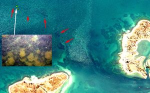
Fig. 5. This aerial photograph near Woods Hole shows large boulder fields (red arrows), which at this site are covered by red algae (inset photo, probably Chondrus), and a colonial bryozoan (tan). Benthic image from Ackerman et al., (2014), Geological Sampling Data and Benthic Biota Classification: Buzzards Bay and Vineyard Sound, Massachusetts. Area delineated with a green boundary line along the coast to the right (Penzance Point), shows previously mapped eelgrass habitat in sandy areas within a boulder field. The delineated area includes both algal covered boulders and eelgrass. Click to enlarge.
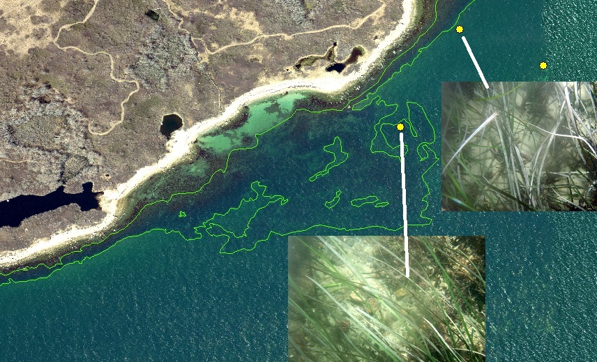
Fig. 6. Eelgrass habitat (green boundary) off Nonamesset Island, Gosnold, MA, in Vineyard Sound. This is a mixed algae and eelgrass habitat site where algae covered boulders along shore grades into a subtidal zone where eelgrass can be found in patches of sand and gravelly sand. Subtidal imagery from a draft 2007 CMECS dataset for a Woods Hole area survey (courtesy of Adrienne Pappal, MA CZM), superimposed on 2014 interpreted imagery.
Other technologies
Acoustic mapping using sonar has been used to map eelgrass beds as illustrated by Fig. 7. This technology can distinguish between algae, seagrass, and other habitat types (see Norton and Dijkstra, 2017, at http://ccom.unh.edu/publications/development-new-acoustic-mapping-method-eelgrass-using-multi-beam-echo-sounder).
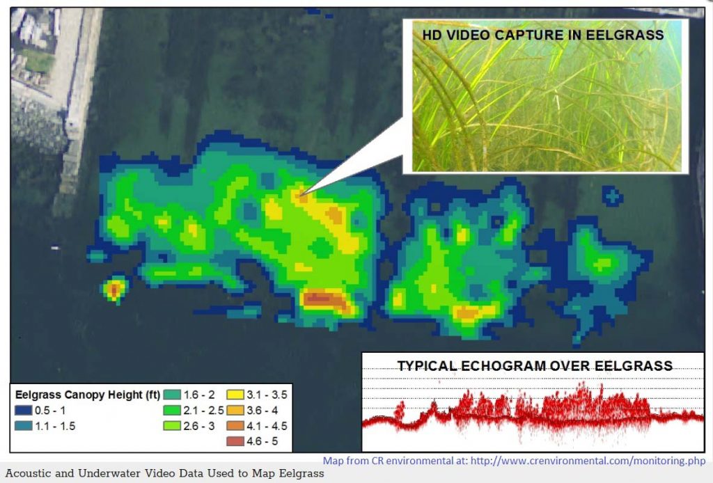
Acoustic mapping of eelgrass. From CR Environmental at http://www.crenvironmental.com/monitoring.php with permission.
Aerial Image Interpretation and Buzzards Bay Benthic Imagery Sources
Ackerman, S.D., Pappal, A.L., Huntley, E.C., Blackwood, D.S., and Schwab, W.C., 2015, Geological Sampling Data and Benthic Biota Classification—Buzzards Bay and Vineyard Sound, Massachusetts: U.S. Geological Survey Open-File Report 2014–1221, 30 p., https://dx.doi.org/10.3133/ofr20141221.
Fienbeiner et al. 2001. Guidance for benthic habitat mapping: an aerial photographic approach, http://aquaticcommons.org/2219/.
Garcia et al. 2015. A Method to Analyze the Potential of Optical Remote Sensing for Benthic Habitat Mapping, http://www.mdpi.com/2072-4292/7/10/13157.
Hubbard reports, videos, and photographs: http://www.coastalamericafoundation.org/crepidulareefs.html and at http://onlinelibrary.wiley.com/doi/10.1111/maec.12275/full.
NOAA Coastal and Marine Ecological Classification Standard (CMECS) system information at: https://iocm.noaa.gov/cmecs/.