The Historical Alewife Run on the Weweantic River to Carver
by Dr. Joe Costa
Historical Descriptions
The Weweantic River had a historically noteworthy herring run and contained other anadromous fish. Until the late 1800s, river herring passed all the way up the Weweantic River to Federal Pond (36 acres), Crane Brook Pond (today 38 acres), and Sampson Pond (302 acres), and along another tributary all the way to Wenham Pond (48 acres) near the Middleborough border. However, this run eventually was destroyed by modifications to the Tremont Iron Works Dam in the late 1800s, and herring passage was permanently blocked. This obstruction has left Horseshoe Pond as the only alewife habitat on the Weweantic River.
In Griffith’s 1913 History of the Town of Carver, he wrote,
“For more than a century, bounties were paid for the heads of crows, blackbirds and red birds, while wolves and wild cats were exterminated in this manner. Beaver were plentiful in the earliest days, but they were exterminated on account of the value of their furs. But while birds and animals diminished the means of subsistence, there were counter advantages of no little consideration. The ponds teemed with fish, Sampson’s, Doty’s [likely the body of water south of Federal Pond and later called Jenkins Pond then converted to cranberry bogs] and probably Clear being breeding grounds for herring, and this was a large item on their bill of fare.”
He further noted,

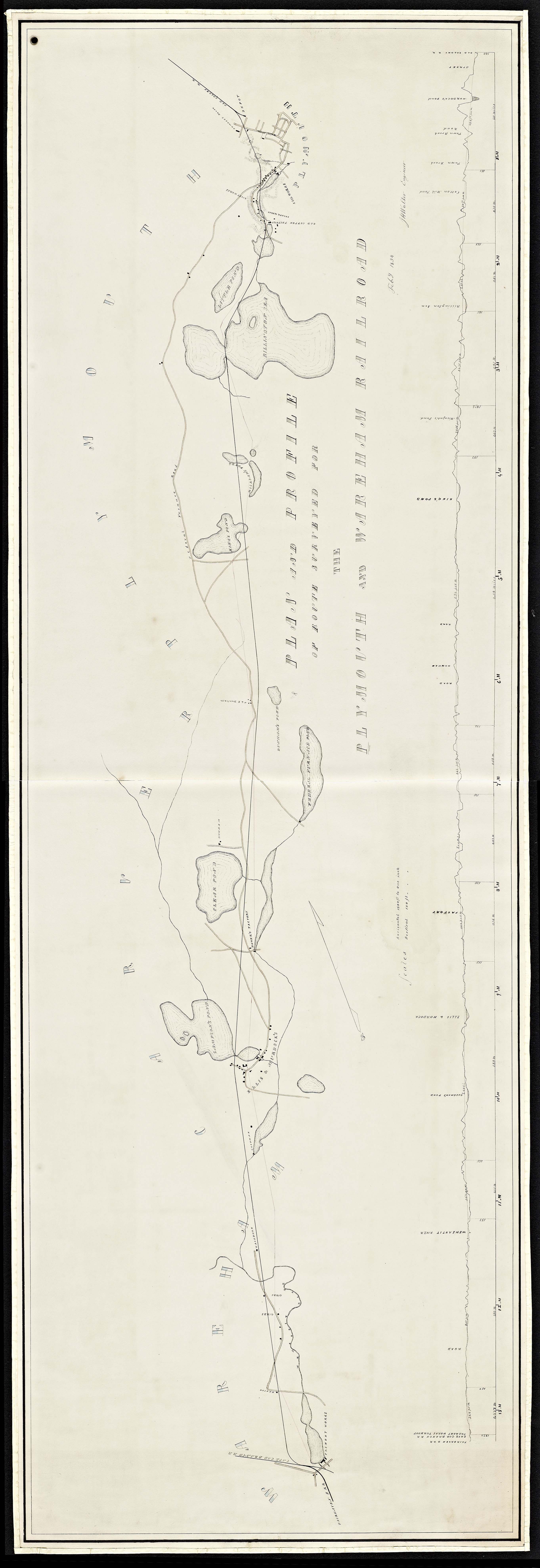
1847 Railroad Plan Map of the lower Weweantic River showing hydrolic connections above Tremont Dam.
Click map to enlarge. Similar 1854 Railroad Plan Map of the lower Weweantic River including the addition of an apparent herring passage bypass at Tremont Dam.

1889-1893 Topographic map of the Weweantic River showing likely earlier herring pathways (blue arrows).
Click map to enlarge. The red line is the Buzzards Bay watershed boundary.

Tremont Iron Works Pond and dam over time.
Click map to enlarge. The 1877 map may show a functioning bypass on the southwest corner of the pond. The pond and dam is now owned by the Town of Wareham. The dam had an operational hydroelectric plant from 1923 until 1938. In 1982, the Town of Wareham received approval to re-establish the hydroelectric facility, although it is no longer operational today.

1903 Map of Dam at Horseshoe Pond. Here the pond dam was operated by the Standard Horse Shoe Company. The pond exists on the 1879 map as operated by the Wareham Nail Works. It also exists on an 1844 topographic map of eastern Massachusetts. Click map to enlarge.

1776 Coastline of Wareham showing the absence of a dam at Horseshoe Pond (TOP LEFT). The 1776 map of Buzzards Bay by Debarre was rubber-sheeted in ArcMap to best match the modern coastline (blue lines). Click map to enlarge.
“Fish formed a staple article of food for the earlier settlers and in the days of the first residents the industry developed three fish weirs. Sampson’s and Doty’s ponds were breeding places for herrings until their egress and ingress was closed by the development of manufacturing along the Weweantic River. These ponds were also stocked with white perch, a valued food fish until the species became land locked, since which it has so far degenerated as to become nearly worthless. During the latter half of the 19th century some of the ponds were stocked with black bass and that species has become the most valuable for food. The list of fresh water fish that have always thrived would include pickerel, red perch, shiners, white fish, roaches, hornpouts and brook trout.”
He also stated that Herring Brook was the former name of stream that ran from Wenham Pond to the Weweantic River (still noted on the 1893 map to the right), but this brook was later turned into a cranberry bog drainage system. As reported in Griffith’s history, as early as 1734, Carver Town Meeting established a herring committee “to take care that there be no stoppage in South Meadow river [which flows to Wenham Pond] to obstruct or hinder the course of the fish either in their going up or going down sd. stream.”
In 1921, Belding, in his treatise on the alewife fishery of Massachusetts, wrote this about the Weweantic River:
“Weweantit [sic] River has its source in Wenham Pond, and flows south for 14 miles to empty into Buzzard’s Bay. The stream is largely used for water power to operate saw and grist mills, and for flooding cranberry bogs. It is slightly polluted with sawdust and trade waste from the factories at South Wareham and Tremont. Below Wenham and Bartlett’s ponds the stream is obstructed by numerous cranberry bog and mill-pond dams, which render it absolutely impossible for alewives to ascend. Fifty years ago alewives ran up Sampson’s Brook, a tributary, which now drains Federal Pond, a reservoir for cranberry bogs, and receives the overflow from Sampson’s Pond. The fishways on the dams at Tremont and South Wareham are obstructed, and practically useless.”
Apparently at least some herring were continued to be collected on the Weweantic River, perhaps at the Horseshoe Pond dam , as he also writes:
“Formerly abundant, the alewives ceased to run to the spawning grounds in Wenham Pond and Sampson’s Pond when the dam of the Tremont Nail Company was installed, some eighty years ago. Since 1874 the receipts from the sale of the Weweantit Alewife Fishery have varied from 33 cents to $21, the ten years previous to 1912 showing an average of $8. The obstructing dams at Tremont and South Wareham, and the cranberry interests at the headwaters with numerous small dams, embankments and other obstructions, practically preclude a successful fishery.”
It is not clear if he was referring to Wareham receipts or Carver receipts. If they are Carver receipts, that implies some form of functioning bypass at the Tremont Dam through 1912.
1815 Historical account of herring in the Weweantic
In an 1815 History of Wareham, the herring run on the Weweantic is mentioned, and a remarkably lucid account of the different spawning habit and biology of alewives and blueblack herring is was provided. The author wrote:
Having collected a few notes, physiological and historical, on the alewife fisheries, we have thought this a proper place to arrange them in one view. Of the alewife, there are, evidently, two kinds, not only in size, but habit, which annually visit the brooks passing to the sea at Wareham. The larger, which set in some days earlier, invariably seek the Weweantic sources. These, it is said, are preferred for present use, perhaps, because they are earliest. The second, less in size to, and usually called” black backs,” equally true to instinct, as invariably seek the Agawam. These are generally barreled for exportation. In the sea, at the outlet of these streams, not far asunder, these fish must for weeks swim in common, yet each selects its own and peculiar stream. Hence an opinion prevails on the spot, that these fish seek the particular lake where they were spawned.
For more interesting observations, read this excerpt from the Massachusetts Historical Society records.
Presumed Historical Pathways of Herring
The map top right shows tiled 1889 and 1893 USGS 15 minute topographic maps covering the Weweantic River and showing the likely path of alewives and bluebacks on the Weweantic River and its tributaries (blue arrows). Today, herring navigate to most ponds of any size, and even the lesser ponds in Rochester and Carver may have been alewife habitat, but they would not be the focus of any notable fishery. The entire river system would have also supported blueback herring, sea run brook trout, and other diadromous fish species. Note that the connection between Tremont Iron Works Dam and Horseshoe Pond was accidentally omitted from the topographic map, but other more detailed maps of the era show the connections and configuration of various bypasses at the dam (map panels below).
Note on Place Name Changes on the Weweantic
Many streams, ponds, and villages around the Buzzards Bay watershed changed over the centuries as important and cultural or natural features changed, as the language evolved. For example, Rock Village in Middleborough (actually just outside the Buzzards bay watershed), used to be called Beaver Dam, but after beavers were extirpated from southeastern Massachusetts in the early 1700s, and the dam disappeared, the area was renamed Rock Village, after a prominent rock near the center of the village. Along the Weweantic River, however, one of the tributaries was called Beaver Brook and Falls in the 1815 description of the town, and remains called Beaver Dam Brook today, with the precise location of beaver falls uncertain (beaver were likely extirpated in Carver by about 1730). Federal Pond was originally called Crane Brook Pond, then Federal Furnace Company Pond, then simply Federal Pond. Horseshoe Pond was originally called the Federal Horse Shoe Company Pond, and Wareham Nail Works Pond earlier. Clear Pond along Crane Brook became Dunham Pond. On the 1776 map to the right, the nearby Agawam River was called the ManKing River.
Restoration Approaches for the Weweantic River
Not only was the Weweantic important for alewives, it contains the state’s only licensed rainbow smelt run. Currently the smelt, which must lay their eggs in brackish water, only use the lower river to the Horseshoe Pond dam. Ultimately, any anadromous fish restoration strategy for the Weweantic River will be defined by the restoration approaches taken at both the Horseshoe Pond and Tremont Pond dams. Tremont Pond is now an insurmountable barrier to anadromous fish, cutting off hundreds of acres of ponds and dozens of miles of upstream habitat. Because water in the dam is 24 feet above stream level, either a fish elevator, or an expensive series of ladders and pools would need to be installed. If for example, the Horseshoe Pond dam is eliminated without action at any action at Tremont Pond, the Weweantic River would no longer be good habitat alewives, although blueback herring and smelt would likely benefit. Because Tremont Pond (31 acres) and all the previously mentioned former herring ponds upstream total 550 acres, a comprehensive Weweantic River anadromous fish restoration effort is warranted because it would appreciably increase anadromous fish habitat in the Buzzards Bay watershed. In the 1990s, DMF had developed designs for the installation of a Denil Ladder at Horseshoe Pond. Because of the social values associated with ponds, and controversies that may arise from dam removal, it is important that the Town of Wareham, property owners, and abutters develop a consensus as to the restoration solutions that will need to be implemented in these two ponds.
References and Links
Belding, D.L. 1921. A Report Upon the Alewife Fisheries of Massachusetts. (10 MB pdf file)
Griffith, H. S. 1913. History of the Town of Carver Massachusetts. (17 MB pdf file)
Weweantic Revisited Useful insights provided by Glooskap and the Frog
DMF Herring Atlas, Weweantic Excerpt
1982 Act authorizing the Town of Wareham to establish a hydroelectric power generating plant.
1981 MHC Reconnaissance Survey Town Report Wareham Information on first hydroelectric facility.
Excerpt 1815 Massachusetts Historical Collectionpages on description of Carver.
Related: 1894 Law relating to the herring fishery on the nearby Wankinko.(also mentions salmon)