Supporting Information Wareham Main Street Stormwater Designs project
Stormwater discharges to the Wankinco River, in Wareham, MA
Status: The RFR closed and a vendor was hired in 2013. Design work was completed in 2013.
In partnership with the Town of Wareham’s Community and Economic Development Authority (CEDA), in 2012, the BBNEP announced it had set aside $20,000 in federal funds to hire an engineering or environmental service firm to develop stormwater treatment designs to reduce volume and pollutants in discharges to the Wankinco River. These discharges collect stormwater from Main Street, Merchants Way, and surrounding areas. The primary purpose of this project is to develop stormwater treatment designs to reduce stormwater-related pollutants discharging into the Wankinco River with the ultimate goal of reducing bacteria discharges to the upper Wareham River estuary to reduce the area or duration of current closures to shellfish resources, and to minimize the possibility of expanding existing closures. Currently the upper Wareham River estuary is closed to shellfishing in the summer season, and the Wankinco River estuary is closed to shellfishing year-round.
In 2013, in partnership with the Town of Wareham’s Community and Economic Development Authority (CEDA), the Buzzards Bay NEP hired Green Seal Environmental, Inc. to develop stormwater treatment designs for drainage area. Through the spring of 2013, the Buzzards Bay NEP staff worked with the selected vendor, Wareham Public Works, and CEDA, to decide upon the most practical stormwater management solutions, given the site conditions and drainage area.
Background Information on the Procurement
The RFR and state contract forms and information are still available on the CommBuys website (search closed solicitations for “Plans for Main Street”). For your convenience, the document is also available in this link: env13_czm07_wareham_stormwater_final.docx.
Key dates
RELEASE OF RFR: December 14, 2012
INFORMATION SESSION: A Bidders’ Conference was held at 11:00 AM on Thursday, December 27, 2012 in the Merchant Way parking lot in Wareham, MA (near the lift station at the east end of the lot along the Wareham River estuary).
The bidders conference was held as scheduled, despite heavy rains. Click to open the Bidders Conference Sign-In Sheet. This handout was also provided, which just presents a synopsis of key points of the RFR.
INQUIRIES ABOUT THE RFR: The Regional Planner accepted questions about this RFR in writing by mail, fax, or email (to: Sarah Williams) through 4 PM, Wednesday, December 26, 2012. Additionally, questions were accepted at the bidder’s conference on Thursday, December 27, 2012.
APPLICATION DUE DATE: Friday, January 11, 2013 by 4:00 PM.
CONTRACT START DATE: February 2013. Contract terminates June 30, 2013.
Overview of Planned Work
The Town of Wareham’s Community and Economic Development Authority (CEDA) applied for and received this stormwater remediation design grant through the Buzzards Bay NEP. The intent of this grant is to fund engineered plans for the remediation of multiple outfalls that discharge stormwater to the Wankinco River, parallel to Main Street, Wareham, in the upper Wareham River estuary. Specifically there are two outfalls that discharge adjacent to Center Street and near the municipal pump station on Merchant’s Way.
Concurrently, the CEDA has also initiated a revitalization project on Main Street that is within the drainage area for these two outfalls. To date, the Wareham CEDA has completed the final streetscape improvements from Central Street to roughly #266 Main Street, approximately 1,100 linear feet along Main Street completed under Phase I. Phase 2 (formerly Phase 3) continues from Central Street to the intersection of Main Street and Sandwich Road. There is a completed design for the streetscape renovation for Phase 2 (formerly Phase 3) which includes topographic survey suitable for that discipline of construction. The town also planned to do additional work in Merchants Way that contributed to the discharge of stormwater in the Wankinco River.


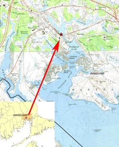
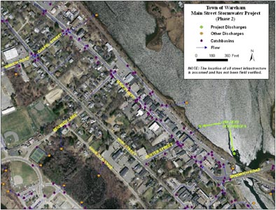
Left: Locus of site. Right: Main St Wareham Stormwater network in Phase 2 Streetscape area (principally between Center Street and Sandwich Road on the map). Click images to enlarge. Locus Maps, click each to enlarge.
Questions Received and Responses to this RFR
Questions received (which may be paraphrased), and answers to those questions. These responses should be considered tentative, and for informational purposes. They were finalized Thursday, January 3, 2013.
Question from past RFR: Is the SBPP-participating business language in Section (1)(J) of the RFR just a goal or a requirement, and must a vendor be a Small Business Purchasing Program (SBPP)-participating business to submit a proposal under this RFR?
Response to Question from past RFR: It is not required that a vendor be a SBPP-participating business to apply, but it is a requirement (pursuant to Executive Order 523) that our program first evaluate bid responses from SBPP-participating businesses), and award the contract to the highest ranking SBPP-participating business that submits a bid that meets or exceeds the solicitation criteria. If determined that there is no SBPP bid that meets or exceeds the solicitation criteria, or if no SBPP-participating vendors provide a responsive bid, then the Department will evaluate and award bid responses received from non-SBPP businesses.
Question 1: How much information regarding the existing drainage system is available? Are there locations, pipe sizes, and elevations available, or is this information that must be developed by the design engineer? There can be considerable cost in developing this information.
Response to Question 1: Some of the needed information is contained in the Main Street revitalization plans, and some information may be contained in other plans available from the Wareham Public Works department. We have not fully researched all available sources of data. Clearly, in a watershed this size, some information is needed with more accuracy and detail than in others. The extent of the drainage system is important information from the point of view in defining the catchment area and for sizing treatment systems. This information may also be used to develop subsequent stormwater treatment concepts. Where a treatment system is proposed for this project, and in certain parts of the network, it can be vitally important to document pipe size and invert elevations so that stormwater flow pathways and volumes are understood.
Question 2: The RFR states that the plans show the location of property bounds and “all utilities and associated services to individual homes and/or businesses.” In the existing plans, are property lines surveyed or estimated? To what extend are surveyed lines needed in the watershed?
Response to Question 2: The property bounds on the existing Wareham Village Streetscape plans are believed to be approximate and based on assessors maps. As noted in the response to question 1, where a treatment system or other construction is proposed for this project, particularly where activity may impinge on private property bounds, surveyed private property bounds may be needed. The intent of the RFR is to survey utilities and property lines in close proximity of proposed construction. In fact, the RFR states, “Detailed property line delineation will be required for final design of any system that would impact private property.” Similarly, where a stormwater treatment facility is proposed to be constructed, the location of utilities is also critical information so that undocumented utility lines are not discovered when construction is about to commence. The Town, the Buzzards Bay NEP, and the contractor is expected to review existing engineering plans prepared previously for the Town of Wareham to make preliminary decisions on the placement of proposed stormwater treatment facilities and construction.
Question 3: Could you provide an explanation of the timing of the deadlines?
Response to Question 3: The town is seeking construction bids in the spring for the Wareham Village Streetscape Phase 2 area (roughly between Center St. and Sandwich Road on the map), so any stormwater designs on this portion of Main Street are needed first, and must be developed sufficiently for the town’s construction bid package. Additional designs for potential treatment systems outside of the Main Street Streetscape Plan can be finalized in the later contract period. Stormwater treatment designs in these areas will be used as the basis of future stormwater treatment grant applications by the town.
List of Respondents
The RFR for this project closed on January 11, 2013. Three proposals were received and the respondents are listed below in alphabetical order:
G.A.F. Engineering, Inc. of Wareham, MA
Green Seal Environmental, Inc. of Sagamore Beach, MA
Norfolk Ram of Plymouth, MA
Available Data Sets

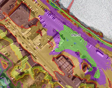
LiDAR data (contours and digital elevation models with, 1 cm precision and 15+/- cm accuracy) is available for the Phase 2 Streetscape area on our FEMA Firm and LiDAR data page. Click the image to enlarge.
Phase 1-3 draft plan designs, partial (phase 3 area now called phase 2)
For more information on this project contact: Sarah Williams