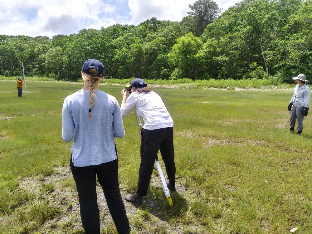
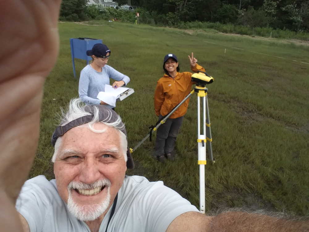
Author: Joe Costa

Buzzards Bay National Estuary Program 2021 in Review

Buzzards Bay Municipal Mini-Grant Program – In November, EEA announced $110,640 in federally funded grant awards for projects that will protect water quality and habitat in the Buzzards Bay watershed. The three grants, which are being matched by over $194,000 in private contributions and state grants, are being awarded by the Buzzards Bay National Estuary Program (NEP) through the Massachusetts Office of Coastal Zone Management (CZM), with funding from the U.S. Environmental Protection Agency (EPA) Southeast New England Program (SNEP). The following grants were awarded:

  • The Town of Mattapoisett: $45,000 to purchase and permanently protect a forested 4-acre parcel of riverfront land. The property is located on the west bank of the Mattapoisett River and contains important state-designated habitat, including habitat for rare species.
  • The Town of Carver: $45,000 to purchase and permanently protect 28 acres of undeveloped forest land on the southern side of the 600+ acre Great South Meadow Cedar Swamp on Mayflower Road in Caver. The property contains important state-designated habitat and lies over the Plymouth/Carver Sole Source Aquifer.
  • The Town of Rochester: $20,640 to purchase a conservation restriction that will permanently protect 20.5 acres along Doggett Brook, a principal tributary of the Sippican River. The property contains important state-designated habitat, including habitat for rare species.

For more information, see the EEA Press Release.

Buzzards Bay Targeted Grants – With support from the U.S. EPA’s Southeast New England Program (SNEP), the Buzzards Bay NEP continues to support an ongoing study by the Ecosystem Center at the Marine Biological Laboratory to evaluate the feasibility of applying permeable reactive barrier technology, using wood chips as a carbon source, to reduce nitrogen inputs from advanced treated wastewater effluent under different controlled flow conditions. This work is being undertaken in partnership with the Wareham Water Pollution Control Facility. The NEP is also supporting a study by the Woodwell Climate Research Center of Woods Hole to measure nitrogen inputs to Buzzards Bay from coastal rivers. With funding support from U.S. EPA headquarters, the Buzzards Bay Coalition is assisting the NEP in a Climate Vulnerability Assessment of the Buzzards Bay Comprehensive Conservation and Management Plan. The Coalition will host meetings and workshops with key stakeholders, synthesize responses, and help develop new recommendations for management action in Buzzards Bay. All these projects will continue through the spring and early summer of 2022.

In 2020, with SNEP funding, the Buzzards Bay NEP retained the engineering firm Horsley Witten Group to evaluate potential stormwater solutions for 15 high priority catchments in the Buzzards Bay watershed where monitoring data and stormwater network information had been gathered through the Buzzards Bay Stormwater Collaborative. The project ended in February 2021, with Horsley Witten Group preparing engineered designs, supporting calculations, and permit filings for three sites in the towns of Acushnet, Fairhaven, Mattapoisett, and Wareham. The NEP then worked with the towns to develop grant applications to fund those designs.

In a related SNEP-funded initiative, UMass Dartmouth completed two student projects. As part of a senior studies project, students developed green stormwater treatment designs for Padanaram Village near the shores of Apponagansett Bay. This project was based on the earlier conceptual plans developed by the NEP’s consultant. In a separate graduate student research project, investigations were undertaken of illicit connections and pollution sources in stormwater networks, including discharges to Tub Mill Brook in Mattapoisett.

Besides these projects, the NEP continued to support the Buzzards Bay Coalition’s Baywatchers water quality monitoring program with a $40,000 grant.

Buzzards Bay Salt Marsh Study) – Salt marshes in Buzzards Bay provide a vital role by providing habitat, regulating water quality, and stabilizing coastlines. In recent years, many coastal towns have experienced the degradation or loss of their salt marshes. To better understand and halt this trend, the Buzzards Bay NEP continues to support efforts by the Buzzards Bay Coalition and scientists at the Woodwell Climate Research Center to study salt marsh loss in Buzzards Bay. In a Buzzards Bay NEP/Buzzards Bay Coalition long-term study, historical loss of salt marshes is being documented by the NEP using aerial photographs, while the Buzzards Bay Coalition is documenting annual changes in marsh vegetation and elevation. In particular, the effort is focusing on how climate change, pollution, and changes in the abundance of certain crab species may be affecting salt marshes. In a second SNEP-funded study, scientists are looking at how use of runnels—constructed shallow drainage meanders—might promote revegetation where upper areas of salt marsh are dying off from standing water. In both studies, the Buzzards Bay NEP is providing GIS mapping analysis using recent and historical aerial photographs and LiDAR data. The NEP also installed elevation benchmarks, conducted elevation surveys using laser levelers and Geographical Positioning System (GPS) equipment, and provided training on the use of the equipment by NEP partners. The results of this work will help town officials and state and federal mangers develop possible mitigation strategies to protect and restore salt marshes. For more information, see the Salt Marsh Study web page.

Continued Support to the Buzzards Bay Stormwater Collaborative – In November, with support from the U.S. EPA’s Southeast New England Program (SNEP), the NEP awarded Massachusetts Maritime Academy a $25,000 grant to continue its ongoing support for the Stormwater Collaborative, a partnership of eight municipalities to monitor stormwater discharges and map stormwater networks. The Buzzards Bay NEP is a partner with the Massachusetts Maritime Academy (MMA) and eight participating municipalities on a SNEP grant to monitor stormwater discharges and map stormwater networks, particularly those contributing to shellfish beds closures. Despite limitations imposed by the COVID-19 closures and a summer without much rainfall, the project continued to meet milestones, and support municipal efforts to comply with their federal MS4 stormwater permits. This summer, municipalities supported these efforts with individual contracts with Massachusetts Maritime Academy. The Buzzards Bay NEP continues to provide technical oversight and continued data processing and analysis, and provides free laboratory testing services to municipalities participating in the Stormwater Collaborative Training videos for the program can be found at the Buzzards Bay Stormwater Collaborative YouTube channel, and the Buzzards Bay Stormwater Collaborative page has additional information about the collaborative.

Technical Assistance – The Buzzards Bay NEP continued to assist municipalities and other partners with GIS analysis, proposal development, review of local projects, and training and support for municipal stormwater permits (MS4) compliance. The NEP provided more than 700 map and GIS products to the Buzzards Bay Coalition, area land trusts, and municipalities in their efforts to protect important habitat and open space in Buzzards Bay. The Buzzards Bay NEP continues to work with the Buzzards Bay Coalition Science Advisory Committee and a team of scientists in Woods Hole to identify pressing issues related climate change, nitrogen and toxic pollution, and loss of wetlands habitat and living resources in Buzzards Bay.

Support to SNEP and SNEP Grant Awardees -The Buzzards Bay NEP is an advising partner to the U.S. EPA in implementing the Southeast New England Program (SNEP) and is a supporting partner to several SNEP grant awardees. In October, the U.S. EPA awarded $750000, over five years to the Buzzards Bay Coalition under the SNEP Pilot Watershed Initiative. The funding will assist in identifying and prioritizing sources of watershed impairments and develop solutions to address stream alteration and nutrient loading in an urbanized area of the Buttonwood Brook-Apponagansett Bay area of Massachusetts. Project partners include the City of New Bedford, the Town of Dartmouth, Buttonwood Zoo, the Friends of Buttonwood Park, and the Dartmouth Natural Resources Trust. The Buzzards Bay NEP is supporting the effort by providing land use analysis and GIS services during the five-year project.

Buzzards Bay NEP Awards $110,640 to Three Towns

The Buzzards Bay National Estuary Program (NEP) awarded three grants totaling $110,640 in federal funds to three Buzzards Bay municipalities. The three grants, which are being matched by over $194,000 in private contributions and state grants, are awarded through the Massachusetts Office of Coastal Zone Management (CZM), with funding from the U.S. Environmental Protection Agency (EPA) Southeast New England Program.

The following municipalities were awarded grants:

  • The Town of Mattapoisett will receive $45,000 to work with its partner, the Mattapoisett Land Trust, to purchase and permanently protect a forested 4-acre parcel of riverfront land. The property is located on the west bank of the Mattapoisett River and contains important state-designated habitat, including habitat for rare species. The property lies across the street from the state-owned Nasketucket Bay State Reservation. Protection of this parcel is part of a larger conservation effort by the Mattapoisett Land Trust to conserve the entire west bank of the Mattapoisett River from Route 6 south to the multi-use path. The Mattapoisett Land Trust intends to create a trail system and small parking area on the property to allow for public access to the property and river.
  • The Town of Carver will receive $45,000 to work with its partner, the Buzzards Bay Coalition, to purchase and permanently protect 28 acres of undeveloped forest land on the southern side of the 600+ acre Great South Meadow Cedar Swamp on Mayflower Road in Caver. The property contains important state-designated habitat and lies over the Plymouth/Carver Sole Source Aquifer. The project will protect the ecological resources associated with a large and significant Atlantic White Cedar stand, as well as protect the headwaters source for multiple small tributary streams that form the upper reaches of the Weweantic River. In addition, acquisition of the property will provide a long sought after gateway access to the Great Cedar Swamp.
  • The Town of Rochester will receive $20,640 to work with its partners, the Buzzards Bay Coalition and Rochester Land Trust, to purchase a conservation restriction that will permanently protect 20.5 acres along Doggett Brook, a principal tributary of the Sippican River. The project is part of a larger effort to protect a 58-acre undeveloped farmland parcel along a principal road to the central village area of Rochester. The property contains important state-designated habitat, including habitat for rare species. The conservation restriction will remove the current agricultural use from within 300 feet of Doggett Brook, and this area will be restored to enhance its ecological functions. In addition, a small roadside gravel parking area and a walking trail will be developed.

For more information about the grant awards, please read this EEA press release.

MMA students start new year with Stormwater Collaborative

In 2015, the Buzzards Bay National Estuary Program (NEP), in partnership with the Buzzards Bay Action Committee, and five Buzzards Bay municipalities (the Towns of Dartmouth, Acushnet, Fairhaven, Mattapoisett and Wareham), established the Buzzards Bay Stormwater Collaborative. The goal of the Collaborative was to help municipalities manage stormwater pollution, primarily by mapping stormwater networks and monitoring stormwater discharges. These are among the most difficult, time consuming, and costly tasks towns face in their stormwater management programs.

In the fall of 2018, the Massachusetts Maritime Academy (MMA), a Massachusetts state college, joined the effort by establishing a program for their students to participate. Three more towns joined the Collaborative as well (the Towns of Bourne, Marion, and Westport). Through the college’s Co-op program, students in the Marine Science, Safety and Environmental Protection Department work for the program and earn required course credits for their degree.

This past summer, now in its third year at the college, five new Stormwater Collaborative students joined the program. Some of these students will continue in subsequent semesters, or new students will join in the fall and spring sessions. Co-op students in the Stormwater Collaborative are taught a variety of skills including the use of GPS equipment, geographic information system software, laboratory testing of water samples, use of field monitoring test equipment, and learning how to collect samples from stormwater networks, and inspect stormwater networks with remote cameras. The photos below illustrate some activities and tasks undertaken by the students. All photos credited to Maura Flaherty, MMA.

In 2019, MMA received a grant from Massachusetts DEP to outfit a trailer with equipment and supplies to undertake field investigations. The NEP guided the design and selection of equipment in the trailer.
Students, under the guidance of municipal and program staff learn how to safely access stormwater networks to inspect them and collect water samples for testing. Left: loosening a catchbasin with a sledge. Middle: removing a manhole cover with a magnetic lift. Right: winching a fallen catchbasin cover.
The students may use a smoke machine to determine network connectivity or to locate an obscured outfall pipe.
After access is achieved, a hand operated clam shovel (left) may be used to clear debris from the catchbasin to observe pipe connections or to collect water samples from connected pipes. A water jet (middle) may be used to clear connecting pipes. Water samples are collected during dry weather and wet weather flows.
While the stormwater system is accessible, the students conduct inspections and may deploy a video camera.
Students also collect samples from pipe discharges, some of which are difficult to access.
Training also includes learning to conduct water quality tests using field meters (middle) and benchtop kits (right). The students also bring samples to certified laboratories for analysis of contaminants, such as bacteria.
The program also trains students on the use of field survey and GPS equipment, and the students record numerous field observations.
The students are trained on basic ArcGIS software skills, like data entry and georeferencing engineering plans, to produce maps they can use in their field work.
Through the Stormwater Collaborative, participating Massachusetts Maritime Academy students are learning many skills that they can use in their careers.