The Buzzards Bay National Estuary Program (NEP), a unit of the Massachusetts Office of Coastal Zone Management, works to protect and restore water quality and living resources in Buzzards Bay and its watershed. In the new year, we look forward to continuing our work with Buzzards Bay municipalities, non-profits, and other partners toward these goals. We are fortunate in that we expect to provide nearly $1.7 million dollars in grants and subawards in 2023. This is a good opportunity to reflect on our work in the past year, and below are the program’s highlights from 2022.
Buzzards Bay Municipal Mini-Grants Program – In June, through its municipal mini-grant program, the Buzzards Bay NEP provided $12,500 to the Town of Carver to hire an engineering firm to conduct fieldwork and produce an updated stormdrain map, which will allow the town to prioritize direct outfalls that pose the most significant threat to the Weweantic River, which runs to Buzzards Bay. Once outfalls are prioritized, the Town can mitigate discharges by installing leaching catch basins with no discharges. In addition, the funds will be used to haul 150 tons of street sweeping/catch basin waste to a disposal facility.
In November, the Buzzards Bay NEP awarded $195,000 in additional federally funded grant awards for projects that will protect drinking water supplies, preserve important habitat, and address pollution from stormwater runoff in the Buzzards Bay watershed. These five grants to four towns, which are being matched by over $132,000 in private contributions and in-kind services, were awarded with funding from the EPA Southeast New England Program (SNEP):
Rochester – $70,000 to work with the Towns of Mattapoisett, Fairhaven, Marion, and Acushnet, along with the Buzzards Bay Coalition, to purchase and permanently protect 240 acres of land important to protect the Mattapoisett River Valley aquifer. This land acquisition is part of a larger coordinated project that aims to protect thousands of acres in the Mattapoisett River Valley. The newly purchased land will protect a multi-town public drinking water supply resource, as well as wetlands, fields, forests, and habitat for fish and wildlife, and it will provide outdoor recreational opportunities for the public. In addition, the project will benefit the resiliency of the aquifer by preventing land use change and associated activities that impact water quality and disrupt groundwater recharge.
Mattapoisett – $35,000 to establish a strategic master plan for stormwater management in the Shipyard Lane area, which lies east of Mattapoisett Village and is a Town of Mattapoisett priority for stormwater remediation. Stormwater runoff from this area discharges into Mattapoisett Harbor and contributes to shellfish bed closures. The Town will inventory the existing infrastructure and develop a master stormwater plan specifically for the Shipyard Lane area. This master plan will serve as a vital planning tool for the design and construction phase. The project will focus on mapping the watershed to identify target areas for stormwater treatment prior to discharge into Mattapoisett Harbor.
Mattapoisett – $35,000 to work with the Mattapoisett Land Trust to purchase and permanently protect two parcels of undeveloped land totaling 14 acres in the Brandt Island Cove area of Mattapoisett. The properties consist of forested wetlands and upland coastal forest and contain important state-designated habitat, including habitat for rare species. The Mattapoisett Land Trust intends to create a trail system, which will connect to a larger network of trails, as well as a small parking area on the property to allow for public access.
Westport – $30,000 to work with the Buzzards Bay Coalition to purchase and permanently protect 25 acres of land associated with the headwaters of Snell Creek, a tributary of the East Branch of the Westport River. Snell Creek is one of only a handful of coldwater streams in Westport that support a native population of sea run brook trout, a climate-vulnerable species that is declining throughout its range due to land use changes, habitat loss, and interactions with non-native species. Coldwater streams (such as Snell Creek) and their habitats are particularly sensitive to temperature increases, which could greatly impact sea run brook trout populations. Protection of this property will ensure continued vegetated shading of the stream and help preserve vital habitats, wetlands, and water quality of Snell Creek.
Fairhaven – $25,000 to work with the Buzzards Bay Coalition to permanently protect 9 acres of land that provide a key upland buffer to wetlands and that protect important wildlife habitats, including state-designated habitat. Protection of the land will also ensure existing saltmarsh can migrate to an undeveloped area as sea level rise begins to flood adjacent low gradient, low elevation uplands. Once acquired, the land will be open to the public for passive recreational purposes and will provide coastal public access to outer New Bedford Harbor.
For more information, see the EEA Press Release.
Buzzards Bay Targeted Grants – With funding from SNEP’s Clean Water Act Section 320 funds and the Bipartisan Infrastructure Law funds, the Buzzards Bay NEP was able to initiate these five subawards.
Baywatchers Program – The NEP continued to support the Buzzards Bay Coalition’s Baywatchers water quality monitoring program with a $40,000 grant. For 30 years, Baywatchers has collected basic water quality, nutrient, and algal pigment information around Buzzards Bay during the summer months and educated the public on local water quality. Since 1992, this effort has directly engaged more than 1,000 citizen scientists and has resulted in an impressive dataset of long-term trends for the ecological health of over 200 locations around the Bay.
Nutrient Inputs to Buzzards Bay from Coastal Rivers – Nitrogen and phosphorus discharged into coastal rivers is one of the major sources of these nutrients in Buzzards Bay. Although the water quality in the estuarine embayments has been monitored for 30 years as part of the Buzzards Bay Coalition’s Baywatchers program, the nutrient input contributed by rivers remains poorly understood. Quantifying nutrient flows from rivers is important for validating watershed pollutant loading models and for understanding how residential and commercial development, land and agricultural management, and ecological restoration activities influence nutrient delivery to Buzzards Bay. Because climate change will bring increasingly variable precipitation to the Northeast, understanding river-borne sources of nutrients to Buzzards Bay will be critical to addressing nutrient loads to the Bay in the future. With a $45,000 award to the Woodwell Climate Research Center of Woods Hole, this river nitrogen loading study, led by Woodwell scientist Chris Neil, continued to monitor 12 Buzzards Bay streams. The funding helped pay for continuous monitoring equipment and laboratory testing to measure nitrogen inputs to Buzzards Bay from these coastal rivers.
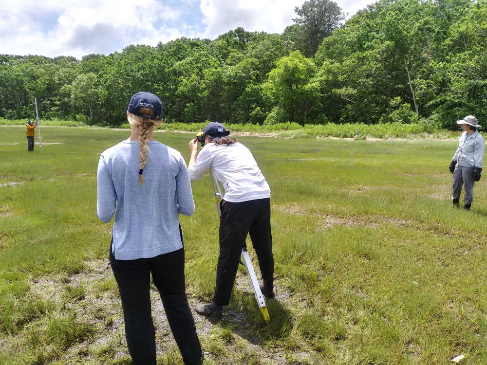
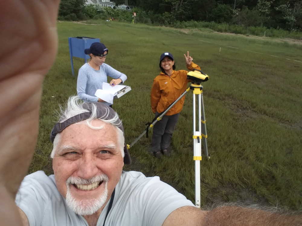
Buzzards Bay Long-Term Salt Marsh Study – Salt marshes in Buzzards Bay play a vital role by providing habitat, regulating water quality, and stabilizing coastlines. In recent years, many coastal towns have experienced the degradation or loss of salt marshes. To better understand and halt this trend, the Buzzards Bay NEP continues to support efforts by the Buzzards Bay Coalition and scientists at the Woodwell Climate Research Center to track salt marsh loss in Buzzards Bay caused principally by climate change related factors. The NEP is interpreting historical aerial photographs and processing elevation data from GPS and field surveys. In 2022, the program expanded through a partnership with the UMass Dartmouth Civil and Environmental Engineering program, with students of Professor Dan MacDonald. The $49,000 award for this project enabled the UMass Dartmouth to conduct field surveys using Unmanned Aircraft Systems. The imagery will be processed with photogrammetry software to generate highly detailed Digital Surface Models and georectified true color imagery. UMass Dartmouth will use existing National Geodetic Survey rod benchmarks installed by the Buzzards Bay NEP as elevation controls. The work will continue through 2023. For more information on the marsh studies, see this Buzzards Bay NEP web post.
New Bedford Public Schools Sea Lab Summer Program – The Sea Lab Marine Science Education Center is a New Bedford Public Schools summer school program supported through tuition and the Local Education Agency. One of the fundamental elements of the Sea Lab program is its focus on providing educational equity for all public-school students. With a $27,500 award from the NEP, Sea Lab will provide scholarships to up to 40 students to enable more minorities and economically disadvantaged youth in New Bedford to participate in the environmental studies program. The NEP funded a student initiative to install water bottle filling stations and provide reusable bottles to reduce the single-use plastic water bottles by the school. The NEP also funded a field trip to Cuttyhunk Island in Buzzards Bay, a whale watch off Cape Cod, and a weather station for the school.
Buzzards Bay Stormwater Collaborative – The Buzzards Bay Stormwater Collaborative is a partnership between the NEP, Massachusetts Maritime Academy (MMA), and eight Buzzards Bay watershed municipalities (Westport, Dartmouth, Acushnet, Fairhaven, Mattapoisett, Marion, Wareham, and Bourne). The focus of the collaborative is to monitor stormwater discharges and map stormwater networks (particularly those contributing to shellfish beds closures) and other municipal stormwater discharges covered under federal Municipal Separate Storm Sewer Systems (MS4) stormwater permits. In December, the NEP initiated a $97,000 award to MMA using EPA funds from the Bipartisan Infrastructure Law to support an MMA program manager and certain administrative costs of MMA co-op students in the program. The students are funded directly by the municipalities in the Collaborative. In 2022, local contributions totaled $70,000. In addition, MMA received a $71,000 grant from MassDEP Municipal MS4 grant program to continue training on the use of a trailer and equipment for detecting illicit discharges into stormwater networks. The Buzzards Bay NEP continues to provide technical oversight, GIS management, data processing and analysis, and free laboratory testing services to municipalities in the Stormwater Collaborative. Training videos for the program can be found at the Buzzards Bay Stormwater Collaborative YouTube channel. For additional information about the collaborative, including an interactive map of stormwater infrastructure and discharge water quality data, see the Buzzards Bay Stormwater Collaborative page.
Technical Assistance – The Buzzards Bay NEP continued to assist municipalities and other partners with GIS analysis, proposal development, review of local projects, and training and support for municipal stormwater MS4 permit compliance. The NEP provided more than 450 map and GIS products to the Buzzards Bay Coalition, area land trusts, and municipalities in their efforts to protect important habitat and open space in Buzzards Bay. The Buzzards Bay NEP continues to work with the Buzzards Bay Coalition Science Advisory Committee and a team of scientists in Woods Hole to identify pressing issues related climate change, nitrogen and toxic pollution, and loss of wetlands habitat and living resources in Buzzards Bay.
SNEP and SNEP Grant Awardee Support – The Buzzards Bay NEP is an advising partner to EPA in implementing SNEP and is a supporting partner to several SNEP and MassDEP grant awards.
Watershed Assessment – The Buzzards Bay NEP is supporting a five-year focus on Apponagansett Bay by the Buzzards Bay Coalition under the SNEP Pilot Watershed Initiative. The funding will help to identify and prioritize sources of watershed impairments and develop solutions to address stream alteration and nutrient loading in an urbanized section of the Buttonwood Brook-Apponagansett Bay area of Massachusetts. The Buzzards Bay NEP is supporting the effort by providing land use analysis and GIS services during the five-year project to support total maximum daily load (TMDL) development.
TMDL Assessment – The NEP is continuing to work with the Town of Bourne and the Buzzards Bay Coalition on a MassDEP 604(b) grant to conduct a TMDL assessment for Red Brook Harbor Phinneys Harbor Complex in the Town of Bourne. The NEP has agreed to complete several tasks for this assessment (at no cost), which will include: conducting GIS analyses of watershed land use, including the number of onsite systems; determining occupancy rates for census data; and determining land use types, including estimates of impervious area, lawn area, extent of sewering, and assessment of pollutant loadings.
Runnel Study – The NEP is supporting a Runnel Study Collaboration between the Woodwell Climate Center and the Buzzards Bay Coalition. Scientists are looking at how the use of runnels—constructed shallow drainage meanders—may promote revegetation in upper areas of salt marsh that are dying off from standing water. The results of this work will help town officials and state and federal mangers develop possible mitigation strategies to protect and restore salt marshes. The NEP is documenting changes in marsh boundaries, and processing GPS and elevation data for the study.
Climate Resiliency Assessment – In 2022, the Buzzards Bay Coalition, in partnership with the NEP, hosted five meetings with key stakeholders to identify concerns about climate change risks and climate adaptation planning in relation to meeting the goals and objectives of the Buzzards Bay Comprehensive Conservation and Management Plan (CCMP). The CCMP is the guiding document used by the NEP in its mission to protect and restore water quality and living resources in Buzzards Bay and its surrounding watershed. This climate vulnerability assessment will be incorporated into the 2023 update of the Buzzards Bay CCMP, where certain strategies may be revised to accommodate expected impacts of climate change.